The Tropical Cyclones Portal

A tropical cyclone is a storm system characterized by a large low-pressure center, a closed low-level circulation and a spiral arrangement of numerous thunderstorms that produce strong winds and heavy rainfall. Tropical cyclones feed on the heat released when moist air rises, resulting in condensation of water vapor contained in the moist air. They are fueled by a different heat mechanism than other cyclonic windstorms such as Nor'easters, European windstorms and polar lows, leading to their classification as "warm core" storm systems. Most tropical cyclones originate in the doldrums, approximately ten degrees from the Equator.
The term "tropical" refers to both the geographic origin of these systems, which form almost exclusively in tropical regions of the globe, as well as to their formation in maritime tropical air masses. The term "cyclone" refers to such storms' cyclonic nature, with anticlockwise rotation in the Northern Hemisphere and clockwise rotation in the Southern Hemisphere. Depending on its location and intensity, a tropical cyclone may be referred to by names such as "hurricane", "typhoon", "tropical storm", "cyclonic storm", "tropical depression" or simply "cyclone".
Types of cyclone: 1. A "Typhoon" is a tropical cyclone located in the North-west Pacific Ocean which has the most cyclonic activity and storms occur year-round. 2. A "Hurricane" is also a tropical cyclone located at the North Atlantic Ocean or North-east Pacific Ocean which have an average storm activity and storms typically form between May 15 and November 30. 3. A "Cyclone" is a tropical cyclone that occurs in the South Pacific and Indian Oceans.
Selected named cyclone -

Hurricane Dorian was an extremely powerful and catastrophic tropical cyclone, which became the most intense on record to strike the Bahamas. It is tied with the 1935 Labor Day hurricane and Hurricane Melissa in 2025 for the strongest landfall in the Atlantic basin in terms of maximum sustained winds. It is regarded as the worst natural disaster in the Bahamas' recorded history. With winds peaking at 185 mph (295 km/h), it was also one of the most powerful hurricanes recorded in the Atlantic Ocean in terms of 1-minute sustained winds, and the strongest since Wilma in 2005. Dorian was the fourth named storm, second hurricane, the first major hurricane, and the first Category 5 hurricane of the 2019 Atlantic hurricane season. Dorian struck the Abaco Islands on September 1 with maximum sustained winds of 185 mph (295 km/h), tying with the 1935 Labor Day hurricane and Melissa for the highest wind speeds of an Atlantic hurricane ever recorded at landfall. Dorian went on to strike Grand Bahama at similar intensity, stalling just north of the territory with unrelenting winds for at least 24 hours. The resultant damage to these islands was catastrophic; most structures were flattened or swept to sea, and at least 70,000 people were left homeless. After it ravaged through The Bahamas, Dorian proceeded along the coasts of the Southeastern United States and Atlantic Canada, leaving behind considerable damage and economic losses in those regions.
Dorian developed from a tropical wave on August 24 over the Central Atlantic. The storm moved through the Lesser Antilles and became a hurricane north of the Greater Antilles on August 28. Dorian proceeded to undergo rapid intensification over the following days, before reaching its peak as a Category 5 hurricane with one-minute sustained winds of 185 mph (295 km/h) and a minimum central pressure of 910 millibars (26.87 inHg) by September 1. It made landfall in The Bahamas in Elbow Cay, just east of Abaco Island, and again on Grand Bahama several hours later, where it remained nearly stationary for the next day or so. After weakening considerably, Dorian began moving northwestward on September 3, parallel to the east coast of Florida. Dwindling in strength, the hurricane turned to the northeast the next day and made landfall on Cape Hatteras at Category 2 intensity on September 6. Dorian transitioned into an extratropical cyclone on September 7, before striking first Nova Scotia and then Newfoundland with hurricane-force winds on the next day. The storm finally dissipated near Greenland on September 10. (Full article...)
Selected article -
_(19877020).jpg)
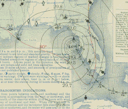
The 1900 Galveston hurricane, also known as the Great Galveston hurricane and the Galveston Flood, and known regionally as the Great Storm of 1900 or the 1900 Storm, was a catastrophic tropical cyclone that became the deadliest natural disaster in the history of the United States. The strongest storm of the 1900 Atlantic hurricane season, it left between 6,000 and 12,000 fatalities in the United States; the number most cited in official reports is 8,000. Most of these deaths occurred in and near Galveston, Texas, after the storm surge inundated the coastline and the island city with 8 to 12 ft (2.4 to 3.7 m) of water. As of 2025, it remains the fourth deadliest Atlantic hurricane on record, behind Hurricane Fifi of 1974. In addition to the number killed, the storm destroyed about 7,000 buildings of all uses in Galveston, which included 3,636 demolished homes; every dwelling in the city suffered some degree of damage. The hurricane left approximately 10,000 people in the city homeless, out of a total population of fewer than 38,000. The disaster ended the Golden Era of Galveston. The hurricane alarmed potential investors, who turned to Houston instead. In response to the storm, three engineers designed and oversaw plans to raise the Gulf of Mexico shoreline of Galveston Island by 17 ft (5.2 m) and erect a 10 mi (16 km) seawall.
On August 27, 1900, a ship east of the Windward Islands detected a tropical cyclone, the first observed that year. The system proceeded to move steadily west-northwestward and entered the northeastern Caribbean on August 30. It made landfall in the Dominican Republic as a weak tropical storm on September 2. It weakened slightly while crossing Hispaniola, before re-emerging into the Caribbean Sea later that day. On September 3, the cyclone struck modern-day Santiago de Cuba Province and then slowly drifted along the southern coast of Cuba. Upon reaching the Gulf of Mexico on September 6, the storm strengthened into a hurricane. Significant intensification followed and the system peaked as a Category 4 hurricane with maximum sustained winds of 145 mph (235 km/h) on September 8. Early on the next day, it made landfall to the south of Houston. The cyclone weakened quickly after moving inland and fell to tropical storm intensity late on September 9. The storm turned east-northeastward and became extratropical over Iowa on September 11. The extratropical system strengthened while accelerating across the Midwestern United States, New England, and Eastern Canada before reaching the Gulf of Saint Lawrence on September 13. After striking Newfoundland later that day, the extratropical storm entered the far North Atlantic Ocean and weakened, with the remnants last observed near Iceland on September 15. (Full article...)
Selected image -

Selected season -

The 2017 Atlantic hurricane season was a devastating and extremely active Atlantic hurricane season that became the costliest tropical cyclone season on record worldwide, with a damage total of at least $294.92 billion (USD). It was the second consecutive above–average season dating back to 2016. The season featured 17 named storms, 10 hurricanes, and 6 major hurricanes. Most of the season's damage was due to hurricanes Harvey, Irma, and Maria. Another notable hurricane, Nate, was the worst natural disaster in Costa Rican history. These four storm names were retired following the season due to the number of deaths and amount of damage they caused. Collectively, the tropical cyclones were responsible for at least 3,364 deaths. The season also had one of the highest accumulated cyclone energy (ACE) on record, with an index of 225 units. A record three hurricanes generated an ACE of over 40: Irma, Jose, and Maria. This season featured two Category 5 hurricanes, and the only season other than 2007 with two hurricanes making landfall at that intensity. The season's ten hurricanes occurred one after the other, the greatest number of consecutive hurricanes in the satellite era, and tied for the highest number of consecutive hurricanes ever observed in the Atlantic basin.
The season officially began on June 1 and ended on November 30. These dates historically describe the period of year when most tropical cyclones form in the Atlantic basin and are adopted by convention. However, as shown by Tropical Storm Arlene in April, the formation of tropical cyclones was possible at other times of the year. In late August, Hurricane Harvey struck Texas and became the first major hurricane to make landfall in the United States since Wilma in 2005, ending a record 12-year span in which no hurricanes made landfall at the intensity of a major hurricane throughout the United States and was the strongest since Charley in 2004. With damages estimated at $125 billion, the storm sequentially tied Hurricane Katrina for the costliest tropical cyclone on record and broke the record for most rainfall dropped by a tropical cyclone in the United States, with extreme flooding in the Houston area. In early September, Hurricane Irma became the first Category 5 hurricane to impact the northern Leeward Islands on record, later making landfall in the Florida Keys as a Category 4 hurricane. In terms of sustained winds, Irma, at the time, became the strongest hurricane ever recorded in the Atlantic basin outside of the Gulf of Mexico and Caribbean, with maximum sustained winds of 180 mph (285 km/h); it was later surpassed in 2019 by Hurricane Dorian. In mid September, Hurricane Maria became the first Category 5 hurricane in history to strike the island of Dominica. It later made landfall in Puerto Rico as a high-end Category 4 hurricane with catastrophic effect. Most of the deaths from this season occurred from Maria. In early October, Hurricane Nate became the fastest-moving tropical cyclone in the Gulf of Mexico on record and the third hurricane to strike the contiguous United States in 2017. Slightly over a week later, Hurricane Ophelia became the easternmost major hurricane in the Atlantic basin on record, and later impacted most of northern Europe as an extratropical cyclone. The season concluded with Tropical Storm Rina, which became extratropical on November 9. (Full article...)
Related portals
Currently active tropical cyclones

Italicized basins are unofficial.
- North Atlantic (2025)
- No active systems
- East and Central Pacific (2025)
- No active systems
- West Pacific (2025)
- No active systems
- North Indian Ocean (2025)
- No active systems
- Mediterranean (2025–26)
- No active systems
- South-West Indian Ocean (2025–26)
- No active systems
- South Pacific (2025–26)
- No active systems
- South Atlantic (2025–26)
- No active systems
Last updated: 11:17, 17 December 2025 (UTC)
Tropical cyclone anniversaries

December 17
- 1944 - Typhoon Cobra hit the United States Navy Fast Carrier Task Force east of Luzon in the Philippine Sea. The storm sank three destroyers and killed 790 sailors.
- 2020 - Cyclone Yasa (pictured) makes landfall over Fiji, killing 4 people. It holds the fourth most intense tropical cyclone in the South Pacific basin, with a minimum barometric pressure of 899 hPa (26.55 inHg).

December 18
- 1959 - Typhoon Gilda made landfall on the eastern Philippine coast, killing 23 people and rendering 230,000 others homeless.
- 2010 - A kona storm develops near the International Dateline, which subsequently developed into Tropical Storm Omeka (pictured).

December 19
- 1990 - Typhoon Russ (pictured) reached its peak intensity with a central pressure of 915 hPa (mbar) to the southeast of Guam.
- 2020 - Tropical Storm Krovanh emerges to the South China Sea after affecting central Philippines, which brought flooding that resulted in 9 fatalities and damages of ₱213.2 million (US$4.48 million).
Did you know…


- …that the Australian region have three distinct lists of names for tropical storms, each one of them being administered by agencies in Australia, Indonesia and Papua New Guinea, respectively?
- …that the Joint Typhoon Warning Center considers that Typhoon Vera (pictured) of 1986 is actually two distinct systems, formed from two separated low-level circulations?
- …that Cyclone Freddy (track pictured) in 2023 was the longest-lasting tropical cyclone recorded?
- …that the typhoons of 2024—Yinxing, Toraji, Usagi, and Man-yi (pictured)—made history as the first recorded instance since 1951 of four tropical cyclones coexisting in November?
General images -
-
 Effects in Buncombe County, North Carolina after Hurricane Helene passed through the area in September 2024. (from Effects of tropical cyclones)
 -
 The initial extratropical low-pressure area forms at the location of the red dot on the image. It is usually perpendicular (at a right angle to) the leaf-like cloud formation seen on satellite during the early stage of cyclogenesis. The location of the axis of the upper level jet stream is in light blue. (from Cyclone)
 -
 Wind damage varies exponentially with wind speed, so that small increases in wind strength can dramatically increase damage. Damages rise by about a factor of four for every category increase in the Saffir–Simpson scale. (from Cyclone)
 -
 Hurricane response involves working in hazardous conditions, including contamination and electrocution hazards from floodwater.
 -
 Surface weather map of the 1935 Labor Day hurricane moving up the west coast of Florida (from Tropical cyclone observation)
 -
 Chart with concurrent information for Hurricane Arlene and Tropical Storm Bret logged and plotted (from Tropical cyclone preparedness)
 -
 The aftermath of Hurricane Katrina in Gulfport, Mississippi. Katrina was the costliest tropical cyclone in United States history. (from Effects of tropical cyclones)
 -
 An example of a chart for Matthew showing its five-day forecast track (from Tropical cyclone preparedness)
 -

-
 Hurricane Isabel (2003)'s effect on the North Carolina Outer Banks (from Effects of tropical cyclones)
 -

-
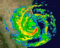 Radar image of Hurricane Erika making landfall over Northeastern Mexico (from Tropical cyclone observation)
 -
 Flooding in Port Arthur, Texas caused by Hurricane Harvey. Harvey was the wettest and second-costliest tropical cyclone in United States history. (from Effects of tropical cyclones)
 -
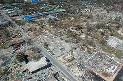
 Aerial image of destroyed houses in Tacloban, following Typhoon Haiyan (from Effects of tropical cyclones)
 -
 The dangerous semicircle is the upper-right corner, with the arrow marking the direction of motion of a Northern Hemisphere storm. Note that typhoons, etc. are asymmetrical, and semicircle is a convenient misnomer. (from Effects of tropical cyclones)
 -
 A fictitious synoptic chart of an extratropical cyclone affecting the UK and Ireland. The blue arrows between isobars indicate the direction of the wind, while the "L" symbol denotes the centre of the "low". Note the occluded, cold and warm frontal boundaries. (from Cyclone)
 -
-
 Broken concrete utility pole in Puerto Rico after Hurricane Maria in 2017, which ranks fourth in costliest US tropical cyclones. (from Effects of tropical cyclones)
 -
 An extratropical cyclone near Iceland (from Cyclone)
 -
 Tropical cyclones form when the energy released by the condensation of moisture in rising air causes a positive feedback loop over warm ocean waters. (from Cyclone)
 -
 Cyclone on Mars, imaged by the Hubble Space Telescope (from Cyclone)
 -
 Percentages of hurricane deaths in the United States from 1970 to 1999. (from Effects of tropical cyclones)
 -
 A polar low over the Sea of Japan in December 2009 (from Cyclone)
 -
 All but the most expensive bottles of water were sold out at this Publix supermarket before Hurricane Irma; in the week preceding the storm, water sold out soon after shipments arrived (from Tropical cyclone preparedness)
 -
 Personnel and equipment from the National Guard of the United States en route to Hurricane Florence response efforts in 2018
 -
 Comparison between extratropical and tropical cyclones on surface analysis (from Cyclone)


.jpg)


_(cropped).jpg)


_(50).jpg)


.jpg)

 Featured list -

The 2001 Atlantic hurricane season was an above-average Atlantic hurricane season in which fifteen named storms formed. The season officially began on June 1 and ended on November 30, dates that conventionally delimit the period of each year when most tropical cyclones form in the Atlantic basin. The season's first tropical cyclone, Tropical Storm Allison, formed on June 5 while the season's final system, Hurricane Olga, dissipated on December 6.
The season produced seventeen tropical depressions, of which fifteen intensified into tropical storms, nine became hurricanes, and four strengthened into major hurricanes. The two most significant storms of the year, in terms of loss of life and damage, were Tropical Storm Allison and Hurricane Michelle. Forming over the northwestern Gulf of Mexico, Allison produced widespread heavy rainfall along its path (most notably across Texas and Louisiana), killing 41 people and inflicting $9 billion (2001 USD) in damage. Following the season, Allison became the first tropical storm to have its name retired by the World Meteorological Organization. Hurricane Michelle was the most intense cyclone of the 2001 season, with winds reaching 140 mph (220 km/h). The storm's impacts extended from the Caribbean Sea to the Bahamas and were most severe in Cuba, cementing its status as one of the costliest cyclones on record there. (Full article...)
Topics
Subcategories

Related WikiProjects
WikiProject Tropical cyclones is the central point of coordination for Wikipedia's coverage of tropical cyclones. Feel free to help!
WikiProject Weather is the main center point of coordination for Wikipedia's coverage of meteorology in general, and the parent project of WikiProject Tropical cyclones. Three other branches of WikiProject Weather in particular share significant overlaps with WikiProject Tropical cyclones:
- The Non-tropical storms task force coordinates most of Wikipedia's coverage on extratropical cyclones, which tropical cyclones often transition into near the end of their lifespan.
- The Floods task force takes on the scope of flooding events all over the world, with rainfall from tropical cyclones a significant factor in many of them.
- WikiProject Severe weather documents the effects of extreme weather such as tornadoes, which landfalling tropical cyclones can produce.
Things you can do
 |
Here are some tasks awaiting attention:
|
Wikimedia
The following Wikimedia Foundation sister projects provide more on this subject:
-
 Commons
Free media repository -
 Wikibooks
Free textbooks and manuals -
 Wikidata
Free knowledge base -
 Wikinews
Free-content news -
 Wikiquote
Collection of quotations -
 Wikisource
Free-content library -
 Wikiversity
Free learning tools -
 Wikivoyage
Free travel guide -
 Wiktionary
Dictionary and thesaurus


