Ołowiane Mountains, Kaczawskie Mountains, Lower Silesian Voivodeship, Polandi
| Regional Level Types | |
|---|---|
| Ołowiane Mountains | Ridge |
| Kaczawskie Mountains | Mountain Range |
| Lower Silesian Voivodeship | Voivodeship |
| Poland | Country |
This page is currently not sponsored. Click here to sponsor this page.

Latitude & Longitude (WGS84):
50° 53' 51'' North , 15° 57' 15'' East
Latitude & Longitude (decimal):
Type:
Köppen climate type:
Nearest Settlements:
| Place | Population | Distance |
|---|---|---|
| Janowice Wielkie | 2,100 (2010) | 3.3km |
| Wojcieszów | 3,933 (2011) | 6.4km |
| Marciszów | 1,528 (2010) | 7.5km |
| Wierzchosławice | 870 (2010) | 9.7km |
| Dobków | 490 (2010) | 10.0km |
Name(s) in local language(s):
Góry Ołowiane, Góry Kaczawskie, Dolnośląskie, Polska
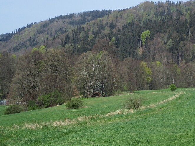
A part of southern mountain ridge belonging to the Kaczawskie Mts. They border with Rudawy Janowickie Mts and the Bóbr River separates them.
Mining areas are located on Brożyna Hill in Janowice Wielkie territory and in border of Ciechanowice where there are adits on Wapienne Slope and ruins of the lime kiln near Bóbr River.
Select Mineral List Type
Standard Detailed Gallery Strunz Chemical ElementsMineral List
2 valid minerals.
Rock Types Recorded
Note: data is currently VERY limited. Please bear with us while we work towards adding this information!
Select Rock List Type
Alphabetical List Tree DiagramDetailed Mineral List:
| ⓘ 'Amphibole Supergroup' Formula: AB2C5((Si,Al,Ti)8O22)(OH,F,Cl,O)2 |
| ⓘ 'Chlorite Group' |
| ⓘ Epidote Formula: (CaCa)(AlAlFe3+)O[Si2O7][SiO4](OH) |
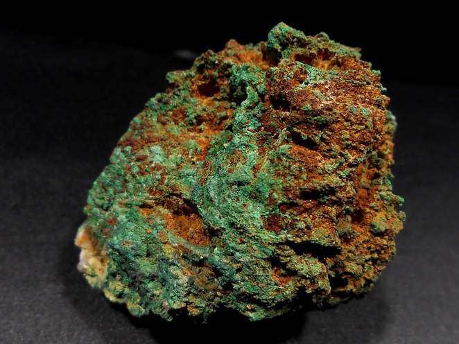
| ⓘ Galena Formula: PbS |
Gallery:
List of minerals arranged by Strunz 10th Edition classification
| Group 2 - Sulphides and Sulfosalts | |||
|---|---|---|---|
| ⓘ | Galena | 2.CD.10 | PbS |
| Group 9 - Silicates | |||
| ⓘ | Epidote | 9.BG.05a | (CaCa)(AlAlFe3+)O[Si2O7][SiO4](OH) |
| Unclassified | |||
| ⓘ | 'Amphibole Supergroup' | - | AB2C5((Si,Al,Ti)8O22)(OH,F,Cl,O)2 |
| ⓘ | 'Chlorite Group' | - | |
List of minerals for each chemical element
| H | Hydrogen | |
|---|---|---|
| H | ⓘ Amphibole Supergroup | AB2C5((Si,Al,Ti)8O22)(OH,F,Cl,O)2 |
| H | ⓘ Epidote | (CaCa)(AlAlFe3+)O[Si2O7][SiO4](OH) |
| O | Oxygen | |
| O | ⓘ Amphibole Supergroup | AB2C5((Si,Al,Ti)8O22)(OH,F,Cl,O)2 |
| O | ⓘ Epidote | (CaCa)(AlAlFe3+)O[Si2O7][SiO4](OH) |
| F | Fluorine | |
| F | ⓘ Amphibole Supergroup | AB2C5((Si,Al,Ti)8O22)(OH,F,Cl,O)2 |
| Al | Aluminium | |
| Al | ⓘ Amphibole Supergroup | AB2C5((Si,Al,Ti)8O22)(OH,F,Cl,O)2 |
| Al | ⓘ Epidote | (CaCa)(AlAlFe3+)O[Si2O7][SiO4](OH) |
| Si | Silicon | |
| Si | ⓘ Amphibole Supergroup | AB2C5((Si,Al,Ti)8O22)(OH,F,Cl,O)2 |
| Si | ⓘ Epidote | (CaCa)(AlAlFe3+)O[Si2O7][SiO4](OH) |
| S | Sulfur | |
| S | ⓘ Galena | PbS |
| Cl | Chlorine | |
| Cl | ⓘ Amphibole Supergroup | AB2C5((Si,Al,Ti)8O22)(OH,F,Cl,O)2 |
| Ca | Calcium | |
| Ca | ⓘ Epidote | (CaCa)(AlAlFe3+)O[Si2O7][SiO4](OH) |
| Ti | Titanium | |
| Ti | ⓘ Amphibole Supergroup | AB2C5((Si,Al,Ti)8O22)(OH,F,Cl,O)2 |
| Fe | Iron | |
| Fe | ⓘ Epidote | (CaCa)(AlAlFe3+)O[Si2O7][SiO4](OH) |
| Pb | Lead | |
| Pb | ⓘ Galena | PbS |
Other Regions, Features and Areas containing this locality
Czech Republic/Germany/Poland
- ⭔SilesiaRegion
Eurasian PlateTectonic Plate
- Saxo-Thuringian BeltOrogenic Belt
EuropeContinent
- Bohemian MassifMassif
- SudetesMountain Range
- Western SudetesMountain Range
- SudetesMountain Range
This page contains all mineral locality references listed on mindat.org. This does not claim to be a complete list. If you know of more minerals from this site, please register so you can add to our database. This locality information is for reference purposes only. You should never attempt to
visit any sites listed in mindat.org without first ensuring that you have the permission of the land and/or mineral rights holders
for access and that you are aware of all safety precautions necessary.
Ołowiane Mountains, Kaczawskie Mountains, Lower Silesian Voivodeship, Poland