Radio Gold Mine (Radio Deeps; Radio North), Bullfinch, Yilgarn Shire, Western Australia, Australiai
| Regional Level Types | |
|---|---|
| Radio Gold Mine (Radio Deeps; Radio North) | Mine |
| Bullfinch | - not defined - |
| Yilgarn Shire | Shire |
| Western Australia | State |
| Australia | Country |
This page is currently not sponsored. Click here to sponsor this page.

Latitude & Longitude (WGS84):
30° 54' 52'' South , 119° 5' 1'' East
Latitude & Longitude (decimal):
Type:
Köppen climate type:
Nearest Settlements:
| Place | Population | Distance |
|---|---|---|
| Southern Cross | 712 (2012) | 41.5km |
| Moorine Rock | 189 (2013) | 45.3km |
| Westonia | 213 (2013) | 56.8km |
The Radio Gold Mine is 8 kilometres north of Bullfinch, bordering the west side of the Mount Jackson Road.
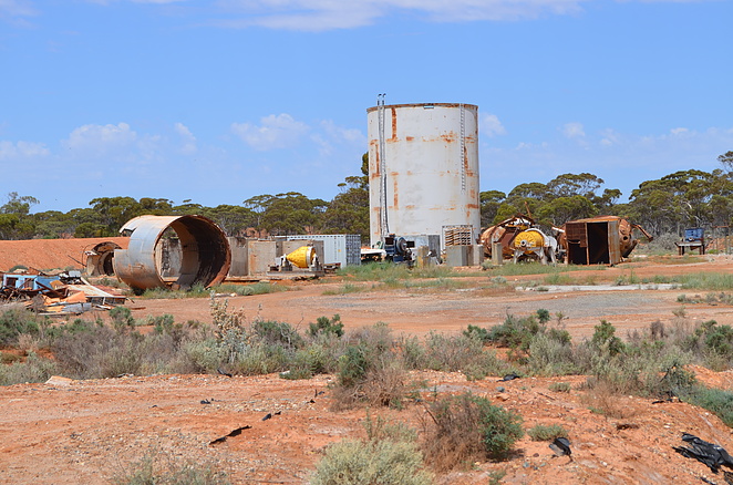
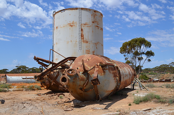
The northern section contains deep trenches, costeans, alluvial workings and possibly shafts. Directly south-west is two small old water filled open pits, with apparently underground workings. Directly east is a large tank, remnants of former processing plants and a large tailings area. Extending south-west are alluvial workings and to the south another tailings area.
There was a wealth of information found about the mine, which has been selectively chosen here due to space limitations. The Radio, Radio Deeps, and Radio North were historically neighbouring mines, but in modern times have been lumped together under one tenement as the Radio Mine.
During the 1920's and 1930's, the Radio Mine was considered to be the richest privately owned two man mine in Australia. It was discovered by Alex Barr and Jack Hughes in 1914. Barr and Hughes had spent 12 months in the area previously discovering very little. A five head battery was erected soon after the discovery.
Alex remained as half owner and mine manager until at least the end of World War Two. Barr was a quietly spoken, stern looking man, with a talent for rifle shooting. Clements was President of the local shooting club.
Jack Hughes was initially the other owner until he died. Jack Clements had migrated to Australia from England in 1910. Bespeckled Clements was in a bar in Southern Cross, when he met Hughes who looked poorly. Clements said ' You need a drink to pull yourself together' (Mindat may not necessarily agree with this health advice!). Hughes stated he had no money so Clements paid for the alcohol, and they became close friends. Hughes later became ill, and Clements looked after him in his Fremantle home, until Hughes died in his arms. Hughes left half the mine to Clements. It is thought Barr and Clements earned a total of 220 000 pounds from the mine in early 20th Century figures.
Samuel Lang owned the neighbouring Radio Deeps Mine which accessed the Golden Harp Lode, a parallel lode to the Radio Mine, via a shaft. While not as rich as the Radio Mine, he earned a not too shabby 80 000 pounds from the mine over the years. He took the lease within a year of the Radio Mine being active, and mined continuously also until at least the end of World War Two.
Limited information was found on Radio North which was not as rich, and worked by prospectors in the 1920's and 1930's. The earliest source states the mine was owned by E. Contessi in 1921. He erected a battery removed from the Corinthian Mine. E.B. Newman went into partnership but they fell out over crushing arrangements. The matter ended in the Warden's Court, and Contessi left to farm in 1923.
Geology-wise modern sources state that gold is found in ultramafic schist, mafic amphibolite and jaspilite, near the contact with banded gneiss and pegmatites. Gold is concentrated in quartz reefs emplaced within north north-east trending fissures. 1991 exploration stated there was narrow but high grade veins remaining.
Another source states it 'appears' to be a series of stacked gold bearing quartz veins, within a low angle thrust system, structurally controlled by quartz vein arrays, related to reverse faults, and linking structures.
E. Broughton-Jensen gave a detailed geology report on the mine in 1925. He states a north north-east trending granite intrusion has produced a crushed zone in which the lode occurs. The lodes form 3 series: the Hanging Wall, Middle and Footwall lodes. Some sources states the lodes are narrow, but pinch and swell along the strike and also vertically. They tend to narrow to the south. Gold is found in the upper levels in schist, but lower in the 3 quartz shoots. The middle shoot was unusually rich. The gold is primary, with no indication of enrichment.
Most mining has not progressed further than 100 metres below the surface, and strikes for 150 metres along the lode. In total the mine has produced 57 333 tonnes of ore at 38.5 g/t Au which is extremely high, yielding 71 050 ounces. Active production ceased in 1974. Mineralisation is thought to continue beyond the boundaries of the historic workings. The processing plant was sold and largely removed in 1988.
Several eastern states companies took out brief options over the mines at various times from 1914 to 1940, but for a number of reasons the owners took back control fairly quickly. In 1954, Uranium Oxide NL and Austral Mining Co took out a 12 month option over the Radio Mine.
Surveys and Mining Ltd re-opened the mine in 1969, and erected a processing plant capable of 200 tonnes of ore per day. The mine was operated by its subsidiary, Western Australian Gold Development NL. Several companies have explored the mine to a limited degree in modern times. Gilt Edge Mining/Alliance Group Pty Ltd 1980's, Carn Brae NL/Golden Valley Mines NL 1991, Gryphon Minerals Ltd 2008, Southern Cross Goldfields 2011, Talga 2011, Renaissance Minerals Ltd 2014,
Select Mineral List Type
Standard Detailed Gallery Strunz Chemical ElementsCommodity List
This is a list of exploitable or exploited mineral commodities recorded at this locality.Mineral List
4 valid minerals.
Rock Types Recorded
Note: data is currently VERY limited. Please bear with us while we work towards adding this information!
Select Rock List Type
Alphabetical List Tree DiagramDetailed Mineral List:
| ⓘ Gold Formula: Au |
| ⓘ Pyrite Formula: FeS2 |
| ⓘ Pyrrhotite Formula: Fe1-xS |
| ⓘ Quartz Formula: SiO2 |
Gallery:
List of minerals arranged by Strunz 10th Edition classification
| Group 1 - Elements | |||
|---|---|---|---|
| ⓘ | Gold | 1.AA.05 | Au |
| Group 2 - Sulphides and Sulfosalts | |||
| ⓘ | Pyrrhotite | 2.CC.10 | Fe1-xS |
| ⓘ | Pyrite | 2.EB.05a | FeS2 |
| Group 4 - Oxides and Hydroxides | |||
| ⓘ | Quartz | 4.DA.05 | SiO2 |
List of minerals for each chemical element
| O | Oxygen | |
|---|---|---|
| O | ⓘ Quartz | SiO2 |
| Si | Silicon | |
| Si | ⓘ Quartz | SiO2 |
| S | Sulfur | |
| S | ⓘ Pyrite | FeS2 |
| S | ⓘ Pyrrhotite | Fe1-xS |
| Fe | Iron | |
| Fe | ⓘ Pyrite | FeS2 |
| Fe | ⓘ Pyrrhotite | Fe1-xS |
| Au | Gold | |
| Au | ⓘ Gold | Au |
Other Regions, Features and Areas containing this locality
Australia
- Western Australia
- Forrestania Nickel Metallogenic ProvinceGeologic Province
- West Australian ElementCraton
- Yilgarn CratonCraton
Australian PlateTectonic Plate
- West Australian Craton
- Western Yilgarn CratonCraton
This page contains all mineral locality references listed on mindat.org. This does not claim to be a complete list. If you know of more minerals from this site, please register so you can add to our database. This locality information is for reference purposes only. You should never attempt to
visit any sites listed in mindat.org without first ensuring that you have the permission of the land and/or mineral rights holders
for access and that you are aware of all safety precautions necessary.
Radio Gold Mine, Bullfinch, Yilgarn Shire, Western Australia, Australia