1. X
  2. NWS Newport/Morehead
Log inOpen app
NWS Newport/Morehead
29K posts
user avatar
NWS Newport/Morehead
@NWSMoreheadCity
Official X Account for National Weather Service, Newport/Morehead City, NC. Details: weather.gov/nws_x
Newport, NC
Joined September 2012
335
Following
19.3K
Followers
RepliesRepliesMediaMedia

Get the full app experience

Unlock more features and see what people are talking about right now.

Open X

New to X?

Sign up now to get your own personalized timeline!

Create account

By signing up, you agree to the Terms of Service and Privacy Policy, including Cookie Use.

Terms·Privacy·Cookies·Accessibility·Ads Info·© 2026 X Corp.
Don't miss what's happening
People on X are the first to know.
Log inSign up
  • user avatar
    NWS Newport/Morehead
    @NWSMoreheadCity
    10h
    [7/16/26 2:50 PM] Due to wildfires in Canada, surface level smoke and an associated decrease in air quality is currently impacting the northeast. Some surface level smoke is expected to progress southward towards VA/NC Friday. #ncwx
    00:00
    3
    9
    935
  • user avatar
    NWS Newport/Morehead
    @NWSMoreheadCity
    17h
    Good morning ENC! Another hot day as temperatures reach the mid to upper 90s inland, "cooling" to near 90 along our beaches. There is a moderate risk of rip currents north of Cape Lookout. #ncwx
    1
    4
    737
  • user avatar
    NWS Newport/Morehead
    @NWSMoreheadCity
    Jul 15
    SUNSET ALERT! (Just after 8!) Smoke + setting sun = spectacular skies tonight. Show us your view and location! 👇 #ncwx
    1
    3
    863
  • user avatar
    NWS Newport/Morehead
    @NWSMoreheadCity
    Jul 15
    There is a 20% chance of TC formation in the next 7 days along the SE coast. While it is TOO SOON to determine what, if any, impacts occur there is an above average chance for rain across the eastern seaboard next week weather.gov/mhx/hurricanep… #ncwx
    1
    6
    644
  • user avatar
    NWS Newport/Morehead
    @NWSMoreheadCity
    Jul 15
    [7/15/26 7 AM] A warming trend begins today, as we approach 100F inland Friday. For today though, slightly less humid conditions may make the temps a *bit* more bearable. #ncwx
    1
    2
    10
    979
  • user avatar
    NWS Newport/Morehead
    @NWSMoreheadCity
    Jul 15
    Not expecting any rain until Sunday. Heat builds rest of week with Friday looking to be the hottest day of the week. MaxTs in the upper 90s and dewpoints in the mid to upper 70s will make Apparent Temperatures ("Feels Like") reach 105-110deg, even hotter in some spots.
    3
    970
  • user avatar
    NWS Newport/Morehead
    @NWSMoreheadCity
    Jul 14
    If a hurricane hit tomorrow, do you have enough daily meds to last? 💊 Storms can shut down local pharmacies. Ensure your emergency kit has a 7-day supply of prescriptions, a first-aid kit, and sanitizing wipes. It's #TropicalTuesday! Prep now: weather.gov/moreheadcity/h… #nws
    00:00
    2
    7
    661
  • user avatar
    NWS Newport/Morehead
    @NWSMoreheadCity
    Jul 14
    Forecast outlook: Above normal temperatures return for the latter half of the week with much of the area expected to experience a Major Heat Risk Thursday through the weekend. A more active weather pattern develops over the weekend and continues into next week.
    Graphic showing the expected Maximum and Minimum Temperatures and chances of rain through this weekend for Greenville, NC.
    3
    694
  • user avatar
    NWS Newport/Morehead
    @NWSMoreheadCity
    Jul 14
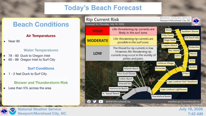
    UPDATE: A high rip current risk now from Duck to Cape Lookout & a moderate rip current risk for Onslow Co. today. Avoid entering the water where the rip current risk is high. Always heed the advice of the local beach patrol and flag warning systems. #ncwx
    Graphic showing the rip current risk from Duck to Surf City, as well as the expected beach conditions.
    2
    623
  • user avatar
    NWS Newport/Morehead
    @NWSMoreheadCity
    Jul 14
    Wind and wave conditions will bring a moderate to high rip current risk across the Outer Banks from Duck to Cape Lookout today. Avoid entering the waters where the rip current risk is high. Always heed the advice of the local beach patrol and flag warning systems. #ncwx
    Graphic showing the rip current risk from Duck to Surf City, as well as the expected beach conditions.
    1
    5
    887
  • user avatar
    NWS Newport/Morehead
    @NWSMoreheadCity
    Jul 13
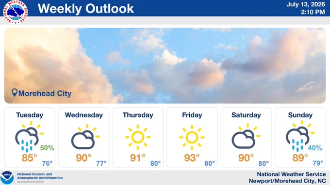
    Low pressure developing offshore will "cool" the area off in NE flow tomorrow with shower chances lingering. Dry and warming into the weekend with rain returning SUN.
    Graphic Showing the expected Maximum and Minimum Temperatures and chances of rain through this weekend for Morehead City, NC.
    4
    728
  • user avatar
    NWS Newport/Morehead
    @NWSMoreheadCity
    Jul 13
    Aviso Especial Marítimo continúa Sur de Ensenada Ocracoke CN hasta Cabo Lookout CN hacia afuera 20 mn hasta las 9:30 AM EDT
    Este gráfico muestra la localización en el mapa de un Aviso Especial Marítimo. El aviso estará en efecto hasta las 9:30 AM EDT. El aviso incluye a Sur de Ensenada Ocracoke CN hasta Cabo Lookout CN hacia afuera 20 mn. Las amenazas asociadas a este aviso son: ráfagas de vientos de mayor de 34 nudos yno se espera granizo. Las trombas marinas no son esperadas. Alto oleaje. Busque un puerto seguro y tome medidas de precaución.
    1
    377
  • user avatar
    NWS Newport/Morehead
    @NWSMoreheadCity
    Jul 13
    Special Marine Warning continues for the Waters from Ocracoke Inlet to Cape Lookout NC from 20 to 60 NM and S of Ocracoke Inlet NC to Cape Lookout NC out to 20 NM until 9:30 AM EDT
    This graphic displays a special marine warning plotted on a map. The warning is in effect until 9:30 AM EDT. The warning includes waters from Ocracoke Inlet to Cape Lookout NC from 20 to 60 NM and S of Ocracoke Inlet NC to Cape Lookout NC out to 20 NM. The threats associated with this warning are wind gusts greater than 34kts and no hail expected.Waterspouts are not expected. Steep waves can be expected. Seek safe harbor and take protective actions.
    3
    382
  • user avatar
    NWS Newport/Morehead
    @NWSMoreheadCity
    Jul 13
    Aviso Especial Marítimo continúa Sur de Ensenada Ocracoke CN hasta Cabo Lookout CN hacia afuera 20 mn hasta las 9:30 AM EDT
    Este gráfico muestra la localización en el mapa de un Aviso Especial Marítimo. El aviso estará en efecto hasta las 9:30 AM EDT. El aviso incluye a Sur de Ensenada Ocracoke CN hasta Cabo Lookout CN hacia afuera 20 mn. Las amenazas asociadas a este aviso son: ráfagas de vientos de mayor de 34 nudos yno se espera granizo. Las trombas marinas no son esperadas. Alto oleaje. Busque un puerto seguro y tome medidas de precaución.
    1
    434