
Widespread showers and thunderstorms may bring areas of flash flooding across much of the Southern Plains into the Gulf Coast region and the upper Ohio River Valley into the Mid-Atlantic. A large Pacific storm will bring widespread rain, gusty winds, and mountain snow to California and the Great Basin. Fire weather concerns expected in the Northern Plains and the Four Corners region. Read More >
Seattle, WA
Center Weather Service Unit
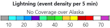
This looping weather page (menu ☰ in upper-left of map) includes satellite imagery (visible, IR, and GeoColor), radar (via AWC and NWS), lightning (GLM data), SIGMETs/CWAs (AWC), PIREPs (AWC), observations (MesoWest), and alerts (NWS).
You can adjust the looping interval (in minutes, snapped to top of hour), number of frames, looping speed, and some overlays.
To force a refresh of the recent data, double-click the NWS logo.
The URL will auto-update with the current settings. To load a default set of parameters (GeoColor Satellite, NWS BREF, GLM, SIGMETs, CWAs, PIREP Intensity, and Alert Severity), click or put "&all=1&" into the URL. To change the default font, put "&fonts=&" with the font list after the = separated by commas and spaces converted to _. To reload this page without presets, please go to https://www.weather.gov/zse/WeatherLoop .
  |
SIGMET/CWA: IFR Turbulence Icing Convective Vol Ash Other SIGMET Other CWA (CWAs Dashed) |
Flight Category: VFR MVFR IFR LIFR |
Weather: Convective Freezing Winter Smoke/Ash Liquid Fog/Haze |

US Dept of Commerce
National Oceanic and Atmospheric Administration
National Weather Service
Seattle, WA
3101 Auburn Way South
Auburn, WA 98092
Comments? Questions? Please Contact Us.


 Follow us on X
 Follow us on Facebook
 Follow us on YouTube
 ZSE RSS Feed