Недавно добавляя заметки чтобы потом по ним добавлять что-либо (ну или проверить место) одну заметку случайно оставил открытой, там я написал “Лево от 7 столба мусорка”. Я даже не мог представить насколько агрессивные местные энтузиасты. Сейчас заметки уже нет (больше месяца прошло с её закрытия) но извините, я не знал что люди умеют лить столько говна за мелкий текст. Хватало мне неделю не заходить на осм так сразу! Люди меня обзывали всем чем только можно, говорили “Смысл этой заметки? Удались!” и “ГНИДА” (просто по приколу походу. Чем я так людей оскорбил? Там на месте бывшей мусорки кто-то машину припарковал? В чём прикол срать без причины?
Users' Diaries
Recent diary entries
Posted by Emi Sunarto on 15 May 2026 in Indonesian (Bahasa Indonesia).
Ada sedikit cerita tentang hal buruk yang saya alami waktu beraktivitas di jalan raya. Tahun 2015 klas1 SMA, jalan menuju sekolah ada kejadian tidak mengenakkan, saya mengalami kontak fisik dengan orang yang tidak saya kenal, itu terjadi di jalan raya dan sekitar 2 meter dari rumah saya, dimana ada 5 orang dan 2 dari mereka melakukan kontak fisik kepada saya, tanpa izin saya. Saya kembali pulang kerumah dengan keadaan menangis. Ketika saya kasih tau orangtua saya, mama saya langsung pergi cari orang-orang itu, dan menjeput saya di sekolah. Ada salah satu teman saya perempuan juga, yang menormalisasikan perbuatan tersebut dan berkata itu hanya memengan tanggan saja. Apakah saya yang terlalu berlebihan? Tapi itu tempat umum mereka berani, bagimana dengan tempat sepi, apakah mereka tidak akan berbuat lebih dari itu? Oleh karena itu, pemetaan jalan aman bagi perempuan sangat dibutuhkan sebagai upaya untuk menciptakan lingkungan publik yang lebih aman, nyaman, dan inklusif. Pemetaan ini membantu mengidentifikasi lokasi-lokasi yang dianggap rawan, minim penerangan, sepi, atau memiliki risiko terjadinya pelecehan dan tindak kekerasan. Dengan adanya pemetaan, pemerintah, komunitas, maupun masyarakat dapat mengetahui area yang memerlukan perhatian dan perbaikan. Selain fasilitas fisik, kesadaran masyarakat juga sangat penting. Lingkungan yang saling peduli, menghormati, dan berani membantu korban dapat meningkatkan rasa aman di ruang publik. Pemerintah, komunitas, dan masyarakat perlu bekerja sama untuk menciptakan lingkungan yang inklusif, aman, dan ramah bagi semua orang, terutama perempuan dan anak-anak sebagai kelompok yang lebih rentan terhadap risiko di tempat publik.
Nice routing algorithm you got, but have you considered I got a map, a vague sense of direction and impeccible luck.
Bin wieder Zuhause mit einer Totalwartezeit von 11 Minuten bei 4 mal umsteigen und bin mit meiner improvisieren Route mit Bus praktisch direkt vor meiner Haustür gelandet. Vielleicht wär mein weg noch schneller gewesen wenn ich statt StreetComplete und Bauchgefühl OSMand verwendet hätte aber guess I dont need to use the data, I just contribute to it…
Mein erstes mal OSM/FOSSGIS Stammtisch Berlin heute war super, bin ab sofort öfter dabei.
(Sorry fürs Denglish)
Contributing commercial vehicle GPS traces from Kerala — a routing approach
I’ve been working on a method to convert commercial vehicle telematics data into useful GPX traces for OSM contribution in Kerala.
The problem
Telematics data is segment-based — each record has a start coordinate, end coordinate, timestamp and distance, but no continuous GPS track in between. Uploading these directly produces straight lines which aren’t useful for mapping.
The solution
I set up a local OSRM instance using the Kerala road extract from Geofabrik, then route-matched each segment to the actual road network. This produces GPX traces with thousands of road-following points instead of straight lines.
Results
From two months of data covering Thrissur, Irinjalakuda, Chalakudy, Kodungallur and surrounding areas:
- 141 road-snapped segments uploaded as GPX traces
- 19 high-priority segments flagged as possible unmapped roads
- These will be cross-checked against aerial imagery in JOSM
Next steps
Reviewing the unmapped road candidates in JOSM against Bing aerial imagery. More vehicle data from the same region will be processed and contributed regularly.
If anyone in the Kerala OSM community has experience with similar data or wants to collaborate on reviewing unmapped road candidates, feel free to reach out.
Tools used: Python, OSRM (self-hosted), gpxpy
First time writing a diary so friend I converted to mapping can find me :D
昨日、久しぶりにOSMのアカウントにLOGINした。 めちゃくちゃ前に残していたログがなつかった。
今つくってるアプリで、ささやかにOSMに貢献できるかも、と思ってる。
ボクは西暦2001年の夏に、豊橋市の小中高の学校や神社や駅などを自転車で回ってパノラマ写真を撮りまくったり、その後も消化器や諸々、GPSのPOI記録しながら狂ったように収集してた。意味あると信じて。結局、HDDが壊れてデータが消えてしまい、いまはもう。
早上,爸爸叫我去学习“正常”的编曲,而不是我自己瞎写的“不正常”编曲,但是我不想学,但我也不知道怎么样解除爸爸的期望,于是我拿起了旁边的剪刀,试图吸引注意,结果爸爸妈妈竟然以为我要杀他们,然后从此决定不再对我有什么感情,不再对我好,并表示可能会把我送进精神病院。 该段落于收集osm商铺poi的路上写下。 还有,蕉饼,你是如何找到我的网盘的?
– Portuguese below
A SPECIAL KEYNOTE ON THE REVISION OF MOZAMBIQUE’S ENVIRONMENTAL LEGISLATION AS AN OPPORTUNITY TO HIGHLIGHT THE IMPORTANCE OF OPENSTREETMAP AND OPEN DATA
On May 13, 2026, a roundtable discussion was held on the implementation strategy for Mozambique’s national environmental policy, which is currently undergoing a major revision. The event was hosted by the Faculty of Earth and Environmental Sciences at the Pedagogical University of Maputo (FCTA UP-Maputo), in partnership with the Brazilian company IVIDES DATA®.

At the invitation of the organizers, Dr. Raquel Dezidério Souto (IVIDES DATA® and UFRJ, Brazil) delivered a special keynote titled “Development & Conservation” (translated from Portuguese), followed by a discussion on the recent Mozambique’s environmental strategy. A copy of the presentation can be found in Portuguese at https://zenodo.org/records/20149423 (*).
Yesterday I cleaned up some map data by removing unnecessary email and unrelated details from several objects. I am learning and trying to follow proper OpenStreetMap mapping guidelines.
把南车站路-中山南路-鲁班路-徐家汇路中间区域的楼全描了,也就是陈欣恬的家、我的家、刘珺瑜的家、我的学校那片。
Posted by SimonPoole on 13 May 2026 in English.
Last updated on 15 May 2026.
[This is a work in progress, IANAL and this isn’t legal advice]
Lots of data is Switzerland is produced by the cantonal GIS offices (while it might seem to originate from swisstopo it often doesn’t), for example the hiking path/trail data is all cantonal and we can only utilise such data, even when using the data distributed by swisstopo, if the cantonal terms are compatible with our license.
In the following I’m using open in a hand wavy, “close enough” fashion here, and not applying the strict definition as per the open defintion. Class A refers to the federal ordinance definition for generally accessible geo data1.
To set the scene: Switzerland does not have sui generis database rights regulation or anything similar, nor does it adhere to a sweat of the brow copyright doctrine. Between non-government entities any (minimal) protection available is based on contract and fair competition law. The big exception is geo data where the federal government has written in to law rights that are essentially a “data copyright light” and many of the cantons have followed suit.2 There is no relevant case law that I know of and how any of this would work out in an actual dispute is, well, open.
My name is Chukwuemeka Emmanuel Nwosu, a 300-level student of the Department of Geography and Environmental Management, University of Port Harcourt. This diary documents my Industrial Training (I.T.) programme as I undergo it.
After careful thought, deliberation, and counsel from my mentor and my brother, I decided to carry out my I.T. programme at the Mapathon Center of the Unique Mappers Team, University of Port Harcourt. I officially resumed on Tuesday, the 11th of May 2026.
On my first day at the Mapathon Center, I had the pleasure of meeting several interesting individuals who, like me, were present for their Industrial Training. Among them were Matel, who serves as our I.T. representative, and Wisdom, both students from the Department of Geology, Rivers State University, and two of my coursemates from the Department of Geography and Environmental Management: Rania and Obasi Emmanuel. I also learned of a few other trainees I had yet to meet in person.
Notably, I was able to complete a part of the week’s assigned task on this very first day. The task required me to create a map of the University of Port Harcourt, situating it within the context of Rivers State and Nigeria as a whole, while clearly indicating the locations of Abuja Park and Delta Park within the university.
Sono entrato a far parte della community OSM da poco, e nell’ultimo mese ho iniziato a prendere sul serio l’attività, decidendo di impegnarmi per tenere aggiornato e arricchire il database. La domanda è: ci sono dei mappatori in provincia di Varese che sono disposti a scambiare opinioni e consigli?
海西州飛地一大塊全劃到西藏去了…怎麼沒人改呢…無語…
二編:已得知唐古拉山鎮南部均租借給西藏。
你好,陈欣恬,我是钱辰飞。很快就又到你的生日了,这一年来,你从未回我一句话。上次你生日,那个球可真好玩,可是我估计一辈子也不会再做出那个球了,因为我已经忘了怎么做了,这有点可惜。初二下对我是很有意义的,这是在小组死后我拥抱个人的降级选择,我和你发生了许多有趣的事情,这些事情历历在目,不可再来,但我也对你做了很多错事,例如硬要送你钱,即使你不要,或者乱说爱你,还有在11上把你弄摔倒。这些事情是个大问题,因为我竟然不考虑你的感受,这可能也是你离开的原因吧。我现在好抱歉,我一直对你做错事,让你在学期末时其实很讨厌我了,而且我在小组群里一直发乱七八糟的东西,偏离了小组的宗旨,让我被其他人也讨厌。桃源兴城苑我是不敢再进去了,我也不应该进去,虽然经常路过,但也就只能远远看看,我也不知道你到底还在不在里面,只是暗中相信你还在。那里真的挺美,地下天窗好好看,好有趣,你和我在那里向下看真实有趣又神经。未来还能不能见到你,我对这个问题的答案是偏向于否定的,我其实不觉得你会想要见到我,反而见到米豪的概率大一点,我可能会带米豪去浙江。 再见,来自小组:钱辰飞。

On the quiet early morning of 18 July 2018, pilgrims from the Mega Arafah Hajj Guidance Group (KBIH Mega Arafah) gathered at the Mega Arafah office near Gedung Sate.

Their first stop was West Java Regional Police headquarters (Mapolda Jabar Gedebage), where pilgrims from across Bandung had assembled.
Posted by darkonus on 12 May 2026 in Ukrainian (Українська).
Last updated on 14 May 2026.
Я створив невеликий втулок для JOSM з назвою Fillet Tools (fillettools.jar).
Він додає інтерактивний режим для заокруглення кутів ліній, подібний до інструмента «fillet» у CAD-програмах. Основний сценарій використання — контури підʼїзних шляхів та інша точна геометрія, де ручне розміщення кількох точок для заокруглення кута займає багато часу.
Ви можете знайти проєкт у репозиторії GitLab, а завантажити перший тестовий jar-файл — зі сторінки релізу v0.1.0.
Як це працює:
- увімкніть режим Fillet Tools на панелі інструментів (або натисніть клавішу V);
- наведіть мишу на лінію або всередину замкнутого багатокутника;
- біля доступних кутів зʼявляться маленькі маркери (ручки);
- потягніть за маркер, щоб побачити і підібрати радіус бажаної дуги;
- відпустіть кнопку миші, щоб застосувати заокруглення.
Також є дві корисні клавіші-модифікатори:
I made a small JOSM plugin called Fillet Tools (FilletTools.jar).
It adds an interactive mode for rounding corners of ways, similar to a fillet tool in CAD software. The motivation is simple: in the real-world, many objects are not designed with sharp corners. Roads, sidewalks, residential landuse areas, sports fields, running tracks, and other planned infrastructure often have smooth, consistent curves. Mapping these curves by hand usually means placing several nodes one by one, which is slow and often inconsistent. Fillet Tools is an attempt to make this specific editing task easier in JOSM.
You can find the project in the GitLab repository, and download the test JAR from the v0.1.2 release.
How it works:
- enable the Fillet Tools mode from the toolbar or by pressing v;
- move the mouse over a way or inside a closed polygon;
- small handles appear near available corners;
- drag a handle to preview the radius;
- release the mouse button to apply the rounded corner.
Posted by mapeadora on 12 May 2026 in Spanish (Español).
Quienes se interesan en la región de América Latina saben que somos relativamente jóvenes en la organización de los States of the Map regionales, iniciados en 2015 después de un encuentro fortuito entre personas apasionadas por OpenStreetMap de diferentes partes de la región durante la conferencia Abrelatam en la Cineteca Nacional de la Ciudad de México en 2014 (mismo contexto en el que se decidió crear un chat de Telegram regional, semilla de la comunidad actual). Posterior a este año, se tuvo cierta continuidad hasta la pandemia, por obvias razones, y también por una desmotivación generalizada de la comunidad, que había vivido cierto “renuevo generacional” que había tenido poca interacción con las pasadas, y, claro, también por la precarización general causada por la pandemia, de la que no nos hemos repuesto ante la situación global actual.
Posted by Raquel Dezidério Souto on 12 May 2026 in Portuguese (Português).
Last updated on 14 May 2026.
– English below
✨ CICLO DE OFICINAS OPENSTREETMAP 2026 PROMOVIDO PELA IVIDES DATA® COMEÇA COM PARTICIPANTES DE PAÍSES LUSÓFONOS
No dia 08 de maio de 2026, iniciamos o Ciclo de Oficinas OpenStreetMap 2026, com participantes de países lusófonos e grande adesão em território brasileiro. Agradecemos a todos que se interessaram em realizar esta formação!
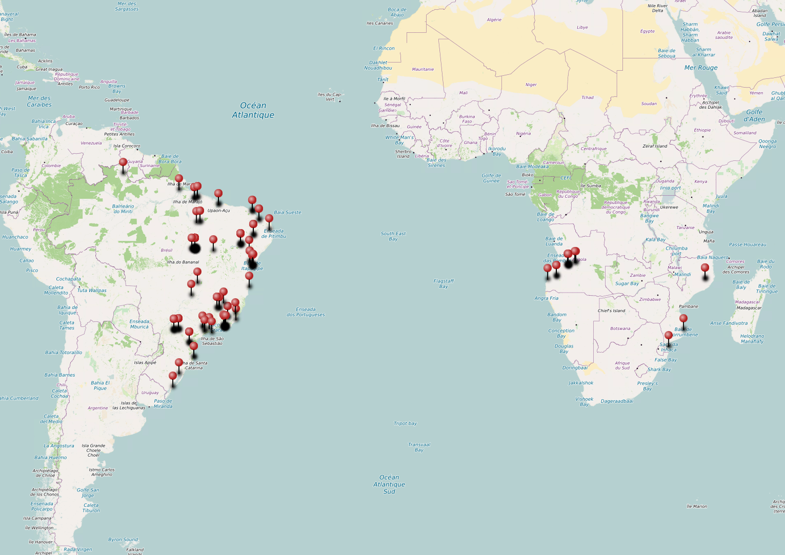
Imagem capturada: Mapa exportado do uMap, com a geolocalização das cidades dos participantes, conforme dados informados por eles mesmos no formulário de inscrição. Dados do mapa de fundo (c) 2026 Contribuidores do OpenStreetMap.