Icla-Brutta Comba Mine, San Germano Chisone, Metropolitan City of Turin, Piedmont, Italyi
| Regional Level Types | |
|---|---|
| Icla-Brutta Comba Mine | Mine |
| San Germano Chisone | Commune |
| Metropolitan City of Turin | Metropolitan City |
| Piedmont | Region |
| Italy | Country |
This page is currently not sponsored. Click here to sponsor this page.
Latitude & Longitude (WGS84):
44° 54' 2'' North , 7° 13' 37'' East
Latitude & Longitude (decimal):
Type:
Köppen climate type:
Nearest Settlements:
| Place | Population | Distance |
|---|---|---|
| San Germano Chisone | 1,474 (2014) | 0.8km |
| Villar Perosa | 3,930 (2014) | 2.6km |
| Pramollo | 258 (2012) | 3.0km |
| Borgo Soullier | 338 (2014) | 3.4km |
| Porte | 611 (2014) | 3.7km |
Other/historical names associated with this locality:
Icla Mine; Brutta Comba Mine
Other Languages:
Italian:
Miniera Icla-Brutta Comba (Miniera Icla; Miniera Brutta Comba), San Germano Chisone, Città metropolitana di Torino (Provincia di Torino), Piemonte, Italia
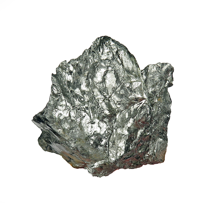
Graphite mine opened in the metasedimentary graphite-bearing sequence of the Pinerolo Unit (Dora-Maira Massif).
Icla-Brutta Comba mine was opened in 1893 on the right side of Risagliardo stream, at the border between the municipal territories of San Germano Chisone and Pramollo, and from 1896 to 1907 was owned by Anglo Italian Talc and Plumbago Mines Company Ltd. of Liverpool, an Italo-British joint venture. In 1907 ownership passed to Società Talco e Grafite Val Chisone and it became the most important graphite mine of the Pinerolo graphite district; operations definitively ceased in 1983. The underground workings, extending more than 5 km, exploited a high-grade graphite layer, ranging from 1 to 3 m in thickness. They ware acceded from Icla Pramollo (coordinates 44.90135449255° N, 7.22020089626° E) and the easternmost Brutta Comba or Icla San Germano (see placeholder). After World War II the number of miners employed at the mine costantly decreased and in 1983, when production ceased, included only a dozen Polish miners paid on a piecework basis.
Select Mineral List Type
Standard Detailed Gallery Strunz Chemical ElementsCommodity List
This is a list of exploitable or exploited mineral commodities recorded at this locality.Mineral List
1 valid mineral.
Gallery:
Other Regions, Features and Areas containing this locality
Eurasian PlateTectonic Plate
- AlpsAccretionary Complex
EuropeContinent
- The AlpsMountain Range
Italy
- Piedmont
- Dora-Maira MassifMassif
- Metropolitan City of Turin
- Chisone ValleyValley
This page contains all mineral locality references listed on mindat.org. This does not claim to be a complete list. If you know of more minerals from this site, please register so you can add to our database. This locality information is for reference purposes only. You should never attempt to
visit any sites listed in mindat.org without first ensuring that you have the permission of the land and/or mineral rights holders
for access and that you are aware of all safety precautions necessary.
Icla-Brutta Comba Mine, San Germano Chisone, Metropolitan City of Turin, Piedmont, Italy