



Journal Description
Earth
Earth
is an international, peer-reviewed, open access journal on earth science published bimonthly online by MDPI.
- Open Access— free for readers, with article processing charges (APC) paid by authors or their institutions.
- High Visibility: indexed within ESCI (Web of Science), Scopus, GeoRef, AGRIS, and other databases.
- Rapid Publication: manuscripts are peer-reviewed and a first decision is provided to authors approximately 21.3 days after submission; acceptance to publication is undertaken in 2.9 days (median values for papers published in this journal in the second half of 2025).
- Journal Rank: JCR - Q2 (Geosciences, Multidisciplinary) / CiteScore - Q1 (Earth and Planetary Sciences (miscellaneous))
- Recognition of Reviewers: APC discount vouchers, optional signed peer review, and reviewer names published annually in the journal.
- Journal Cluster of Geospatial and Earth Sciences: Remote Sensing, Geosciences, Quaternary, Earth, Geographies, Geomatics and Fossil Studies.
Impact Factor:
3.4 (2024);
5-Year Impact Factor:
3.0 (2024)
Latest Articles
Spatial Dynamics and Drivers of Carbon–Pollution Synergy in the Middle Reaches of the Yangtze River Urban Agglomeration
Earth 2026, 7(3), 86; https://doi.org/10.3390/earth7030086 (registering DOI) - 23 May 2026
Abstract
►
Show Figures
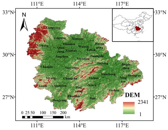
Reducing carbon emissions while improving air quality is a central challenge for rapidly urbanizing regions. Focusing on 31 prefecture-level cities in the Middle Reaches of the Yangtze River Urban Agglomeration, this study examines carbon–pollution synergy (CPS), spatial dynamics, and the driving factors of
[...] Read more.
Reducing carbon emissions while improving air quality is a central challenge for rapidly urbanizing regions. Focusing on 31 prefecture-level cities in the Middle Reaches of the Yangtze River Urban Agglomeration, this study examines carbon–pollution synergy (CPS), spatial dynamics, and the driving factors of CO2 and representative air pollutants from 2013 to 2023. Spatial autocorrelation analysis, a revised four-factor Logarithmic Mean Divisia Index (LMDI) decomposition, and a factor-based CPS assessment were used to identify spatial clustering, compare driver heterogeneity, and evaluate coordination between CO2 and primary pollutants. To improve methodological consistency, the LMDI decomposition and CPS assessment focus on the primary pollutants SO2, CO, and NO2, whereas PM2.5 and O3 are retained in the spatial analysis and discussion because they are strongly affected by secondary formation, atmospheric transport, and meteorological conditions. The results show that CO2 and the selected pollutants exhibit significant but pollutant-specific spatial clustering. High CO2 values remain concentrated in the core cities of Wuhan, Changsha, and Nanchang, PM2.5 shows a persistent north–south gradient, and SO2 hotspots shift from traditional industrial cores toward peripheral areas receiving industrial relocation. The revised LMDI results show that economic development is the most stable positive driver of CO2 and the primary pollutants, whereas the energy-consumption factor generally suppresses emissions. The recalculated population-scale factor fluctuates around 1, indicating a comparatively limited and stage-dependent contribution once the other factors are controlled for. CPS analysis further indicates that coordinated reduction is most robust under the energy-consumption factor and, for conventional combustion-related pollutants, also under the energy-structure factor. Overall, the region has a clear basis for CPS governance, but effective implementation requires pollutant-specific and region-specific control strategies rather than a uniform co-mitigation pathway.
Full article
Open AccessArticle
Estimating the Impact of Agricultural Land-Use–Land-Cover Change on Riverbank Stability and Critical Inland Navigation Areas of the Danube River
by
Maxim Arseni, Valentina-Andreea Calmuc, Madalina Calmuc, Laureana Odajiu, Silvius Stanciu and Puiu Lucian Georgescu
Earth 2026, 7(3), 85; https://doi.org/10.3390/earth7030085 (registering DOI) - 22 May 2026
Abstract
►▼
Show Figures
Intensive agriculture, deforestation, and frequent land-use changes contribute to increased soil erosion and sediment transport from both arable and non-arable lands into minor river channels. These factors directly and indirectly influence riverbank erosion and, in turn, sediment transport in rivers. Evidence on anthropogenic
[...] Read more.
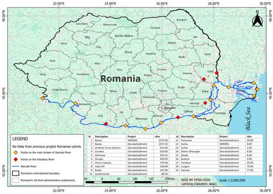
Intensive agriculture, deforestation, and frequent land-use changes contribute to increased soil erosion and sediment transport from both arable and non-arable lands into minor river channels. These factors directly and indirectly influence riverbank erosion and, in turn, sediment transport in rivers. Evidence on anthropogenic land-use/land-cover (LU-LC) change impact remains limited in both quantitative and spatial terms within the Danube River Basin. The study area includes research results from 17 locations concerning satellite-derived LU-LC changes along the Romanian sector of the Danube River, as well as validation results with particular highlighting on the Corabia area, Romania. According to results derived from combining LU-LC products based on Copernicus satellite data (comparing the years 2000 and 2018) and validated in the field through UAV flights conducted in 2025, the conversion of riparian vegetation into cultivated or uncultivated land accelerates bank failure. This is particularly evident where agricultural areas are located in the immediate vicinity of riverbanks. Such bank failures can be attributed to a reduction in root cohesion and a decrease in soil–bank structural stability. As a consequence, sediment delivery to the river channel increases via overland flow. The workflow proposed in this study offers a transferable and adaptable solution for areas with similar characteristics for a multitemporal approach regarding the influence of agricultural lands especially on sediment transport and riverbank erosion.
Full article

Figure 1
Open AccessArticle
Groundwater and Its Ecological Effects in an Alpine Endorheic Region: Implications for Sustainable Management
by
Zhen Zhao, Xianghui Cao, Guangxiong Qin, Yuejun Zheng, Kifayatullah Khan and Wenpeng Li
Earth 2026, 7(3), 84; https://doi.org/10.3390/earth7030084 (registering DOI) - 22 May 2026
Abstract
►▼
Show Figures
Groundwater is one of the key factors affecting the changes and evolution of surface processes in arid regions, determining the direction and scope of the evolution of surface eco-hydrological processes. To achieve sustainable water resource management in arid areas, this study aims to
[...] Read more.
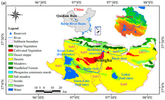
Groundwater is one of the key factors affecting the changes and evolution of surface processes in arid regions, determining the direction and scope of the evolution of surface eco-hydrological processes. To achieve sustainable water resource management in arid areas, this study aims to systematically explore the dynamic changes in groundwater level and their ecological effects on the basis of multi-source remote sensing data by multivariate statistical methods. The results show that groundwater levels in the Bayin River Basin increased from 2895.35 m in 2005 to 2906.75 m in 2022 at a rate of 6.7 m/decade, driven by increased runoff and irrigation. Conversely, groundwater levels in urbanized areas near Delingha City slightly decreased by approximately 0.3 m/decade, with a general west-to-east declining spatial gradient. These changes have generated cascading ecological effects. Overall, rising groundwater has coincided with increased vegetation index, wetland extent, and soil moisture. Annual average NDVI rose from 0.18 in 2000 to 0.23 in 2022, an increase of 27.7%, and wetland area expanded from 349.25 km2 in 2005 to 355.25 km2 in 2022. Soil moisture content showed an insignificant upward trend form 0.14% in 2003 to 0.15% in 2022, with the slope of 0.01%/yr. However, soil salinization has exhibited an aggravating trend, with salinization index (SI) values of 0.25, 0.26, and 0.31 in 2000, 2010, and 2020, respectively. Affected by human activities and geological constraints, the ecological effects associated with groundwater level changes display pronounced regional heterogeneity. This study provides a solid basis for regional water resource regulation and further quantification of water conveyance benefits.
Full article

Figure 1
Open AccessCorrection
Correction: Bachtiar et al. Spatial Variation in Transport-Related Particulate Matter Fractions Across Urban Districts in Padang, Indonesia: Evidence from Nano Sampler-Based Measurements. Earth 2026, 7, 50
by
Vera Surtia Bachtiar, Purnawan Purnawan, Reri Afrianita, Yega Serlina, Haldi Reivan Thamrin, Zulva Shabri and Assyifa Raudina
Earth 2026, 7(3), 83; https://doi.org/10.3390/earth7030083 (registering DOI) - 22 May 2026
Abstract
►▼
Show Figures
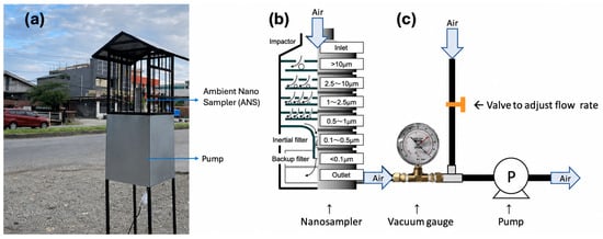
The correction concerns Figure 1 of the published article [...]
Full article

Figure 1
Open AccessArticle
Assessing the Impact of Urban Spatial Pattern Changes on Heat Mitigation by Green and Blue-Green Infrastructure Using the InVEST Model
by
Carla Iruri-Ramos, Karla Vilca-Campana, Lorenzo Carrasco-Valencia, Andrea Chanove-Manrique, María Rosa Cervera Sardá and Berly Cárdenas-Pillco
Earth 2026, 7(3), 82; https://doi.org/10.3390/earth7030082 (registering DOI) - 19 May 2026
Abstract
Green and blue-green infrastructures are key for reducing the effects of urban heat islands driven by rapid city expansion. However, the spatial relationship between land-cover patterns and air-temperature distribution, plus the combined cooling effects of green and blue spaces, remains insufficiently explored. This
[...] Read more.
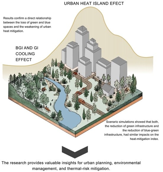
Green and blue-green infrastructures are key for reducing the effects of urban heat islands driven by rapid city expansion. However, the spatial relationship between land-cover patterns and air-temperature distribution, plus the combined cooling effects of green and blue spaces, remains insufficiently explored. This study applies the InVEST Urban Cooling Model to analyze the spatiotemporal changes in land use and their impact on the heat-mitigation service provided by green and blue spaces in the city of Arequipa, Peru, between 2006 and 2024. Furthermore, land-use change is projected for 2030 using the CA-Markov model and the InVEST Scenario Generator tool. These projections enabled the evaluation of two heat-mitigation scenarios by modifying the spatial distribution of green, blue-green, and urbanized areas. The findings indicate that urbanized areas doubled over the measurement period. The greatest loss of agricultural land and tree-covered areas occurred between 2020 and 2024, with a decline of up to 5%. Correspondingly, the percentage of low heat mitigation index areas (0.1–0.2 and ≤0.1) increased by 3.8%, reaching a total increase of up to 6.7%. Scenario simulations showed that reducing both green and blue-green infrastructure had similar impacts on the heat-mitigation index, providing valuable insights for urban planning and environmental management.
Full article
(This article belongs to the Special Issue Climate-Sensitive Urban Design for Heatwave Mitigation)
►▼
Show Figures

Graphical abstract
Open AccessArticle
Assessing Existing and Potential Future Vulnerability to Water Resources Changing Conditions Using Dynamic Composite Indices in Latin America
by
Christos A. Karavitis, Constantina Vasilakou, Dimitrios E. Tsesmelis, Nikolaos A. Skondras, Panagiotis D. Oikonomou, Kleomenis Kalogeropoulos, Panagiotis A. Balabanis, Rodrigo Maia, Enrique Playán, Nery Zapata, Jorge Gironás, Luiz Gabriel Azevedo, Monica Porto, Manuel Vanegas, Santiago Maria Reyna, Dionysis Assimacopoulos, João Pedro Pêgo, Andreas Tsatsaris, Garyfalia Economou, Stavros Alexandris, Vassilia Fassouli, Konstantinos Chatzithomas, Iordanis Moustakidis and Pantelis E. Barouchasadd
Show full author list
remove
Hide full author list
Earth 2026, 7(3), 81; https://doi.org/10.3390/earth7030081 (registering DOI) - 18 May 2026
Abstract
Integrated water resources management uses decision-making and planning techniques in developing long-term strategies to ensure the sustainability of water resources and the resulting water security of future generations. Policy formulation through such integrated planning interlinks with indicators serving as an information channel to
[...] Read more.
Integrated water resources management uses decision-making and planning techniques in developing long-term strategies to ensure the sustainability of water resources and the resulting water security of future generations. Policy formulation through such integrated planning interlinks with indicators serving as an information channel to decision-makers. The present effort aims to develop a specific methodology using technical, environmental, and social indicators, formulating composite indices to identify vulnerability to changing water conditions. Thus, a set of indices developed through a multiyear research effort in Latin America, namely Drought Vulnerability Index (DVI), Water Stress Vulnerability Index (WSTVI), Water Scarcity Vulnerability Index (WSCVI), and Water Changing Conditions Vulnerability Index (WCCVI). Time series analysis covered the years 1991–2020, whereas the reference period was 1961–2020. Climate and water resources information is mainly obtained from ERA5-Land reanalysis; social, economic, infrastructure, and institutional data derived from harmonized sources (COROADO Project-EU, FAO, The World Bank, WHO/UNICEF JMP). Statistical tests and Principal Component Analysis (PCA) identified the indicators included in the equations for each index. Expert knowledge played an important role in the development as data were collected according to known local specificities and global trends, as well as scientific criteria and methodological rigor regarding the proposed new indices. Finally, application of such a framework for spatially explicit analysis indicated higher levels of vulnerability to changing water conditions in the northern part of Mexico, the Andes, Bolivia, Paraguay, and Central America, and lower levels in Chile, Brazil, Uruguay, and Argentina. This application demonstrates that the produced composite indices may be implemented with matching success all over Latin America and, therefore, in diversified natural, technical, environmental, social and economic conditions.
Full article
Open AccessArticle
Ecological Greening in Mu Us Sandy Land: Agricultural Expansion Impacts Assessed by Arid RSEI
by
Ling Nan, Qiaorui Ba, Chengyong Wu and Xiangxiang Hu
Earth 2026, 7(3), 80; https://doi.org/10.3390/earth7030080 - 14 May 2026
Abstract
►▼
Show Figures
Satellite-observed greening in arid regions is often interpreted as ecological restoration success, yet this assessment may conflate natural recovery with agricultural expansion. We developed an Arid Remote Sensing Ecological Index (ARSEI) incorporating a Comprehensive Salinity Index (CSI) to address systematic biases in the
[...] Read more.
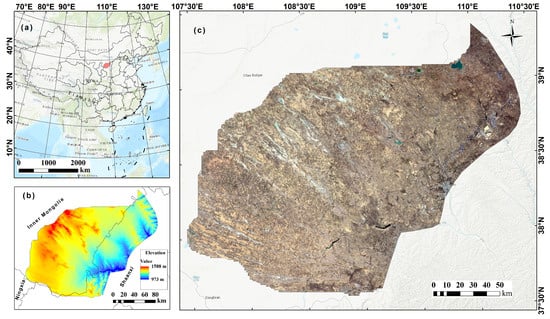
Satellite-observed greening in arid regions is often interpreted as ecological restoration success, yet this assessment may conflate natural recovery with agricultural expansion. We developed an Arid Remote Sensing Ecological Index (ARSEI) incorporating a Comprehensive Salinity Index (CSI) to address systematic biases in the traditional RSEI when applied to irrigated drylands. ARSEI scores were validated against MODIS Net Primary Production (NPP) ( at the regional scale), confirming its reliability in capturing ecosystem productivity, while CSI effectively maps the upper-bound of surface salinization potential dictated by intrinsic soil properties. Applied to China’s Mu Us Sandy Land (2000–2024), the ARSEI reveals that 2327 km2 of sandy land—54% of current cropland—was converted to agriculture, creating “assessment-induced false greening” signals. While the traditional RSEI increased monotonically (+135%), the ARSEI shows a nuanced pattern with plateau (2010–2015) and decline (2015–2020) phases, reflecting salinization risks masked by high crop NDVI. Optimal Parameters-Based Geographical Detector analysis demonstrates that Land Cover × Precipitation interactions (q = 0.28) drive spatial heterogeneity through irrigation-mediated water redistribution. The ARSEI provides a dialectical evaluation framework: acknowledging agricultural greening’s economic benefits while monitoring subsurface degradation risks. This study offers a critical methodological advance for sustainable land assessment in global drylands undergoing agricultural intensification.
Full article

Figure 1
Open AccessArticle
Possibilities of Implementing Solar Sludge Drying Facilities in Existing Wastewater Treatment Plants in the Canary Islands
by
Emilio Megías and Manuel García-Román
Earth 2026, 7(3), 79; https://doi.org/10.3390/earth7030079 - 12 May 2026
Abstract
►▼
Show Figures
Following the completion of the installation and commissioning of a solar sludge drying system serving the largest wastewater treatment plant on the island of Tenerife, a study has been carried out on the possibilities of implementing this type of infrastructure in other important
[...] Read more.
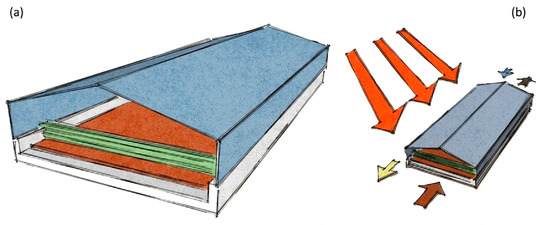
Following the completion of the installation and commissioning of a solar sludge drying system serving the largest wastewater treatment plant on the island of Tenerife, a study has been carried out on the possibilities of implementing this type of infrastructure in other important plants in the Canary Archipelago. To this end and given the favorable climatic conditions found in the Canary Islands for this type of facility, the availability of land and possible impacts on surrounding areas have been studied. There are potential implementations on the islands. Thanks to these facilities, the volume of sludge to be transported to disposal or reuse areas is drastically reduced. The major drawback of these systems is the significant amount of land required, which is not always available on densely populated islands with rugged terrain.
Full article

Figure 1
Open AccessArticle
Seismic Shake-e 2.1 App to Contribute to Mitigating the Seismic Risk
by
Armando Aguilar-Meléndez, Josep De la Puente, Marisol Monterrubio-Velasco, Alejandro García-Elías, Jesús Huerta-Chua and Armando Aguilar-Campos
Earth 2026, 7(3), 78; https://doi.org/10.3390/earth7030078 - 11 May 2026
Abstract
Seismic Shake-e is a free app that provides valuable data and tools related to earthquakes, covering the stages before, during, and after seismic events. In this text, we describe the main features of the Seismic Shake-e 2.1 (SSe) app, the considerations that guided
[...] Read more.
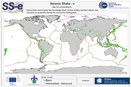
Seismic Shake-e is a free app that provides valuable data and tools related to earthquakes, covering the stages before, during, and after seismic events. In this text, we describe the main features of the Seismic Shake-e 2.1 (SSe) app, the considerations that guided its development, examples of its use, and the challenges for future versions. Version 1.0 of this app was awarded as one of the winners of EOVALUE: Call for Innovative Apps in environmental and social fields, a project by the Joint Research Centre (JRC), the European Commission’s science and knowledge service. SSe recognizes two user levels: basic and intermediate/advanced. There are six modules for each level. The main topics of these modules for both user types are: (1) Accelerometer Networks (AN), (2) Seismograms Analyzer-e (SAe), (3) Seismic Design of Buildings (SDB), (4) Earthquake Preparedness (EP), (5) Earthquake Early Warning Systems (EEWS) & Tsunami Warning Systems (TWS), and (6) Earthquake Emergency Response & Recovery. The two key modules are AN and SAe: the first explains how to obtain seismic records, and the second provides tools for their analysis. We include some applications of SSe, along with their results and discussion. We also list the advantages of the main modules and discuss potential future developments and improvements. The uniqueness of this work is that we highlight the software’s essential features and demonstrate its applications.
Full article
(This article belongs to the Special Issue Feature Papers for AI and Big Data in Earth Science)
►▼
Show Figures

Figure 1
Open AccessArticle
Impact of AIFS and GFS Initialization on WRF Operational Forecasts During High-Impact Storms in Spain (2025)
by
Raúl Arasa Agudo, Matilde García-Valdecasas Ojeda, Miquel Picanyol Sadurní and Bernat Codina Sánchez
Earth 2026, 7(3), 77; https://doi.org/10.3390/earth7030077 - 9 May 2026
Abstract
►▼
Show Figures
The Artificial Intelligence Forecasting System (AIFS), recently released by the European Centre for Medium-Range Weather Forecasts (ECMWF), represents a major shift in global weather prediction by replacing traditional physically based approaches with machine-learning methods. This study evaluates the impact of using AIFS as
[...] Read more.
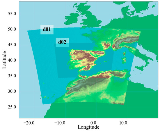
The Artificial Intelligence Forecasting System (AIFS), recently released by the European Centre for Medium-Range Weather Forecasts (ECMWF), represents a major shift in global weather prediction by replacing traditional physically based approaches with machine-learning methods. This study evaluates the impact of using AIFS as initial and lateral boundary conditions for the Weather Research and Forecasting (WRF) model, in contrast to the well-established physically based GFS. The aim of this work is to analyze the sensitivity of these different modelling configurations during three high-impact storms that affected Spain in 2025 and the effects of replacing GFS for AIFS as lateral and boundary conditions for WRF over the accuracy of operational forecasts. The analysis focuses on maximum wind gusts, accumulated precipitation, and the generation of meteorological warnings. Results show that AIFS substantially underestimates wind gusts with mean bias values between −13 and −25 km/h, and its forecasts differ markedly from those of GFS. When coupled with WRF, however, both AIFS-WRF and GFS-WRF produce similar results, with a general tendency to overestimate gusts, with mean bias values between 4 and 15 km/h. In all cases, WRF adds value, improving the representation of wind-related variables compared with the raw global model outputs. For accumulated precipitation, both WRF configurations reproduce the main rainfall patterns associated with the storms. AIFS-WRF shows a stronger tendency to overestimate precipitation, with RMSE values of 64, 23, and 12 mm for the different high-impact storms considered, although it also achieves the highest correlations. Finally, the analysis of meteorological warnings indicates that AIFS alone generates almost no wind gusts alerts. Once coupled with WRF, both configurations generate warnings in the regions where the most severe conditions occurred. Overall, while the added value of mesoscale models such as WRF is well established and confirmed here, the AI-based AIFS does not show clear advantages in comparison with traditional global models for these high-impact events being analyzed.
Full article

Figure 1
Open AccessArticle
Impact of Impervious Surface Expansion on Urban Thermal Environment Across Tropical Southeast Asian Megacities: Reliable Assessment Through Foundation Model Embeddings
by
Sitthisak Moukomla, Phurith Meeprom and Kritchayan Intarat
Earth 2026, 7(3), 76; https://doi.org/10.3390/earth7030076 - 8 May 2026
Abstract
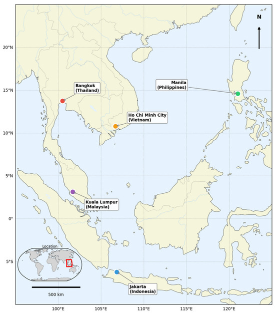
Rapid urbanization in tropical Southeast Asia is transforming pervious land into impervious surfaces, intensifying the surface urban heat island (SUHI) effect and increasing the need for consistent urban thermal monitoring. This study assesses how impervious surface area (ISA) expansion relates to the urban
[...] Read more.
Rapid urbanization in tropical Southeast Asia is transforming pervious land into impervious surfaces, intensifying the surface urban heat island (SUHI) effect and increasing the need for consistent urban thermal monitoring. This study assesses how impervious surface area (ISA) expansion relates to the urban thermal environment across five tropical megacities (Bangkok, Jakarta, Manila, Kuala Lumpur, and Ho Chi Minh City). AlphaEarth geospatial foundation model embeddings were used to reduce observation gaps caused by persistent cloud-cover, while MODIS land surface temperature (LST) was used to quantify the thermal response. We compared AlphaEarth classification against conventional Sentinel-2/NDVI approaches and an additional fairer annual Sentinel-2 full-band-plus-index Random Forest baseline, quantified ISA expansion for 2017–2024, and related ISA fraction to dry-season LST at 1 km resolution. Repeated random-holdout tests based on Google Earth Engine samples showed AlphaEarth mean IoU = 0.866 (95% CI: 0.857–0.875), compared with 0.758 (0.749–0.767) for the annual Sentinel-2 full-band-plus-index baseline and 0.686 (0.674–0.698) for the best single-date 5-index baseline. Spatial-block holdout tests gave similar but slightly lower values (AlphaEarth IoU = 0.859; annual Sentinel-2 baseline = 0.747; best single-date baseline = 0.673). Ho Chi Minh City experienced the fastest ISA expansion (+11.0 percentage points; slope = 1.48 pp yr−1, 95% CI: 1.06–1.91), whereas Bangkok reached the highest ISA fraction (65.1%). ISA fraction and LST were consistently and positively associated across cities and years (Pearson r = 0.748–0.900), and mean SUHI intensity during 2017–2024 ranged from 4.01 °C in Bangkok to 8.51 °C in Manila. These results indicate that foundation model embeddings can support cloud-resilient mapping of impervious surface change and thereby improve assessment of tropical urban thermal environments, while also highlighting the need for independent ground-truth validation.
Full article
(This article belongs to the Special Issue Climate-Sensitive Urban Design for Heatwave Mitigation)
►▼
Show Figures

Figure 1
Open AccessArticle
Evolution of DOM Composition and Hydrochemical Characteristics in Rivers of the Huaibei Plain: Gradient Effects from Agriculture to Urbanization
by
Kangdong Wang, Songbao Feng and Hao Yu
Earth 2026, 7(3), 75; https://doi.org/10.3390/earth7030075 - 4 May 2026
Abstract
►▼
Show Figures
Rapid urbanization imposes significant pressure on riverine water environments, yet the evolution of hydrochemical characteristics and dissolved organic matter (DOM) in rivers across urbanization gradients within developing regions, such as the Huaibei Plain, remains inadequately understood. Thus, this study investigates the hydrochemical and
[...] Read more.
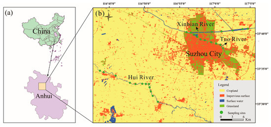
Rapid urbanization imposes significant pressure on riverine water environments, yet the evolution of hydrochemical characteristics and dissolved organic matter (DOM) in rivers across urbanization gradients within developing regions, such as the Huaibei Plain, remains inadequately understood. Thus, this study investigates the hydrochemical and DOM characteristics of rivers across distinct urbanization gradients (suburban, peri-urban, and urban) in this area. Using an excitation–emission matrix coupled with a parallel factor analysis (EEM-PARAFAC) and hydrochemical analyses, we found that while rock weathering is the primary major ion source, human activities distinctly alter water profiles. Agriculturally dominated suburban rivers had significantly higher nitrate (NO3−) concentrations than those in urban and peri-urban rivers. Their DOM was predominantly humic-like (C1, C3) with a high humification index (HIX), indicating a substantial input of soil-derived humic substances driven by runoff from the agricultural catchment. Conversely, urban and peri-urban rivers exhibited higher chloride (Cl−) concentrations due to domestic sewage. Their DOM was dominated by protein-like components (C2 and C4, averaging 65–68%), with high biological indices (BIX) reflecting autochthonous origins. Correlation analysis confirmed these anthropogenic impacts: NO3− positively correlated with humic-like components and HIX, while Cl− strongly correlated with protein-like components. These findings confirm that DOM components and spectral indices are effective tracers of anthropogenic disturbance and hold promise for monitoring and predicting water quality, thus providing a scientific basis for improved water resource management and restoration strategies.
Full article

Figure 1
Open AccessArticle
Multi-Scenario Modeling of Carbon Storage Services for Evaluating Land Use/Land Cover Protection Strategies in the Cimanuk Watershed, Indonesia
by
Salis Deris Artikanur, Widiatmaka Widiatmaka, Wiwin Ambarwulan, Irmadi Nahib, Wikanti Asriningrum and Ety Parwati
Earth 2026, 7(3), 74; https://doi.org/10.3390/earth7030074 - 30 Apr 2026
Abstract
►▼
Show Figures
Carbon is an essential component in the regulation of climate systems through the global biogeochemical cycle. However, changes in land use/land cover (LULC) have reduced the capacity of terrestrial ecosystems like watershed to store carbon. This shows the need for a policy framework
[...] Read more.
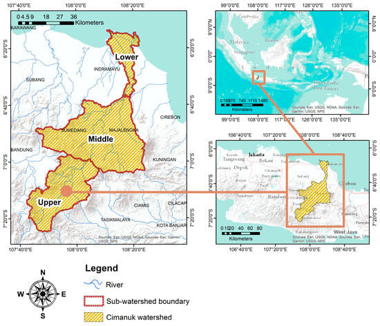
Carbon is an essential component in the regulation of climate systems through the global biogeochemical cycle. However, changes in land use/land cover (LULC) have reduced the capacity of terrestrial ecosystems like watershed to store carbon. This shows the need for a policy framework that balances conservative objectives with agricultural demands, as watersheds are required to support carbon storage and food production. Previous studies have generally assessed carbon dynamics or LULC change separately, with limited integration of policy-driven scenarios. Therefore, this study aimed to conduct multi-scenario carbon storage modeling to evaluate LULC protection strategies in the Cimanuk Watershed, Indonesia, an area experiencing significant LULC pressures. The method used consisted of Support Vector Machine (SVM)–Markov, the Integrated Valuation of Ecosystem Services and Trade-offs (InVEST), Geodetector, and Getis-Ord Gi*. A total of four scenarios were used to project LULC and carbon storage in 2042, which included Business as Usual (BAU), Paddy Field Protection (PFP), Forest Protection (FOP), and Paddy Field and Forest Protection (PFFOP). The results showed that forest area declined by 39,400 ha between 2015 and 2025, thereby reducing carbon storage. The PFFOP scenario was identified as the most viable, combining the protection of paddy fields and forests to balance agricultural production and carbon sequestration. Among the factors analyzed, slope exerted the greatest influence on carbon storage. Spatial cluster analysis showed that carbon hotspots were predominantly located in the upper Cimanuk sub-watershed. These results offered valuable insights into scenario-based sustainable watershed management to optimize carbon storage and maintain agricultural function. Furthermore, the proposed framework showed promising potential for application in other tropical watersheds, serving as a reference for decision-makers in sustainable watershed management.
Full article

Figure 1
Open AccessArticle
Gamma Dose Rates in Protected Mountain Areas near Belgrade Using In Situ Measurements, Remote Sensing and GIS
by
Aleksandar Valjarević, Ljiljana Gulan and Uroš Durlević
Earth 2026, 7(3), 73; https://doi.org/10.3390/earth7030073 - 30 Apr 2026
Abstract
►▼
Show Figures
This study investigates the spatial distribution of ambient dose equivalent rates (ADER) on Avala and Kosmaj mountains, two protected landscapes located within the territory of the City of Belgrade, Serbia. Both sites, characterized by rich biodiversity and cultural heritage, were analyzed to assess
[...] Read more.
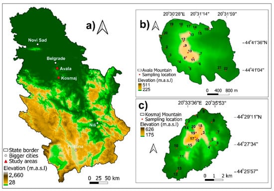
This study investigates the spatial distribution of ambient dose equivalent rates (ADER) on Avala and Kosmaj mountains, two protected landscapes located within the territory of the City of Belgrade, Serbia. Both sites, characterized by rich biodiversity and cultural heritage, were analyzed to assess their radiological safety and suitability for outdoor recreation. In mid-October 2025, in situ measurements were conducted at 42 sampling points using the Radex RD1503+ GM counter. The recorded values ranged from 0.085 to 0.2 µSv/h, remaining below the recommended safety threshold of 0.2 µSv/h. To visualize the gamma dose spatial variability, all field data were georeferenced and processed in QGIS 3.28.10 using the Inverse Distance Weighting (IDW) interpolation method. Integration of GIS and Remote Sensing techniques enabled the correlation between gamma radiation patterns, land cover, and elevation gradients derived from digital elevation models (DEMs). The comprehensive GIS-based approach confirms that Avala and Kosmaj maintain low natural background radiation levels comparable to global averages for similar geomorphological settings, and therefore are safe and suitable for sports, tourism and recreation. The applied combination of field dosimetry, Remote Sensing, and geostatistical modeling provides a valuable framework for continuous environmental monitoring and sustainable landscape management in protected mountainous landscapes in Central Serbia.
Full article

Figure 1
Open AccessArticle
Disentangling Climate and Demographic Drivers of Urban Heat Risk: A Geographically Weighted Regression Analysis of Zagreb (2001–2024)
by
Dino Bečić and Mateo Gašparović
Earth 2026, 7(3), 72; https://doi.org/10.3390/earth7030072 - 28 Apr 2026
Abstract
►▼
Show Figures
Urban heat risk is intensifying globally, yet the relative contributions of climate warming and demographic restructuring to spatiotemporal risk change remain poorly understood, particularly in post-socialist cities experiencing simultaneous thermal intensification and population aging. This study develops a Heat Risk Population Index (HRPI)
[...] Read more.
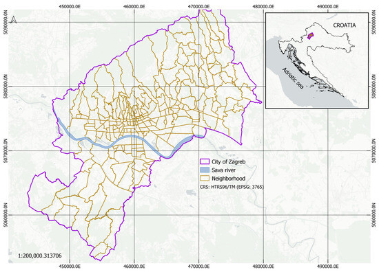
Urban heat risk is intensifying globally, yet the relative contributions of climate warming and demographic restructuring to spatiotemporal risk change remain poorly understood, particularly in post-socialist cities experiencing simultaneous thermal intensification and population aging. This study develops a Heat Risk Population Index (HRPI) integrating satellite-derived land surface temperature, CERRA reanalysis air temperature, and census-based demographic sensitivity for 218 Zagreb neighborhood councils (2001–2024). A multi-scale analytical framework combining additive decomposition, enhanced partial correlations, and geographically weighted regression (GWR) was applied to disentangle the drivers of heat risk change. HRPI increased significantly across all neighborhood councils (mean ΔHRPI = 0.197, p < 0.001), with strong positive spatial autocorrelation (Moran’s I = 0.416). While air temperature change dominated the city-wide mean increase (72.1%), demographic sensitivity change explained the largest share of spatial variance across neighborhood councils (partial r = 0.677 vs. 0.524 for air temperature), driven by spatially heterogeneous demographic transitions—youth out-migration, aging-in-place in southeastern post-socialist estates, and gentrification in central districts. GWR substantially outperformed global OLS (ΔAICc = 60.1; Adj. R2: 0.649 → 0.816), with local demographic effect sizes varying fivefold across the city. These results demonstrate that heat risk drivers operate at distinct spatial scales: climate dominates city-wide magnitude while demographics determine spatial differentiation. Effective adaptation requires universal thermal interventions combined with spatially targeted demographic strategies in identified hotspot neighborhoods. The multi-scale framework is applicable to other post-socialist cities undergoing concurrent climate and demographic change.
Full article

Figure 1
Open AccessArticle
Multiscale Drought Assessment in Kien Giang Province, Vietnam: Comparing MSPI and MSPEI for Monitoring in a Coastal Mekong Delta Setting
by
Dang Thi Hong Ngoc, Ngo Thi Hieu, Tran Van Ty, Nguyen Anh Hung, Pankaj Kumar, Nigel K. Downes and Huynh Vuong Thu Minh
Earth 2026, 7(3), 71; https://doi.org/10.3390/earth7030071 - 28 Apr 2026
Abstract
►▼
Show Figures
Drought is a recurrent hazard in the Vietnamese Mekong Delta (VMD), with major implications for agriculture, water resources, and rural livelihoods. This study assesses drought variability in Kien Giang Province, Vietnam, from 1992 to 2024 using two multiscale indicators: the Multivariate Standardized Precipitation
[...] Read more.
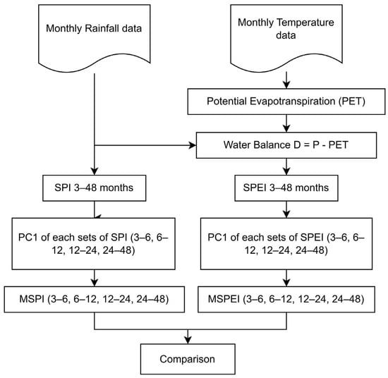
Drought is a recurrent hazard in the Vietnamese Mekong Delta (VMD), with major implications for agriculture, water resources, and rural livelihoods. This study assesses drought variability in Kien Giang Province, Vietnam, from 1992 to 2024 using two multiscale indicators: the Multivariate Standardized Precipitation Index (MSPI) and the Multivariate Standardized Precipitation Evapotranspiration Index (MSPEI). Principal Component Analysis (PCA) was applied to Standardized Precipitation Index (SPI)- and Precipitation Evapotranspiration Index (SPEI)-based time series spanning multiple accumulation periods (3–48 months) to derive integrated drought signals and to reduce redundancy across timescales. The results show that the first principal component (PC1) captured a high proportion of total variance across stations, indicating strong coherence in drought dynamics across the province. Both MSPI and MSPEI successfully identified major historical drought episodes, particularly the severe events of 2004–2005 and 2015–2016. However, the two indices differed in their temporal behaviour: MSPI responded more directly to precipitation deficits, whereas MSPEI showed slower post-drought recovery in recent years, suggesting greater sensitivity to evaporative demand and climatic water-balance stress. These differences indicate that evapotranspiration-sensitive indices may provide added analytical value in warming coastal environments. Overall, the combined multiscale framework offers a robust basis for drought monitoring, comparative assessment, and water-resource planning in Kien Giang and other drought-prone coastal delta settings.
Full article

Figure 1
Open AccessArticle
Sustainable Development Goals in the Horn of Africa: Human Rights to Food, Water, Health, and Education
by
Karen G. Añaños, Wendi A. Gonzales Asto, Alina D. Corpodean and José A. Rodríguez Martín
Earth 2026, 7(2), 70; https://doi.org/10.3390/earth7020070 - 21 Apr 2026
Abstract
The Horn of Africa (Kenya, Djibouti, Uganda, Eritrea, Somalia, Ethiopia, South Sudan, and Sudan) faces the highest rates of hunger and malnutrition in the world, exacerbated by conflict and adverse weather conditions. These factors have serious health, educational, social, and economic consequences, especially
[...] Read more.
The Horn of Africa (Kenya, Djibouti, Uganda, Eritrea, Somalia, Ethiopia, South Sudan, and Sudan) faces the highest rates of hunger and malnutrition in the world, exacerbated by conflict and adverse weather conditions. These factors have serious health, educational, social, and economic consequences, especially for children under five and pregnant women. In this context, we analyze each country’s progress toward Sustainable Development Goals (SDGs) 1, 2, 3, and 4, which are closely linked to the eradication of hunger, improved health, and access to quality education. Using comparable data from the United Nations 2030 Agenda up to 2019, the achievement of the SDGs is assessed through a multidimensional approach based on Pena’s P2 distance method, constructing a composite indicator that allows for robust cross-country comparisons. This method helps identify the key measures needed to prevent future humanitarian crises in the Horn of Africa, including providing urgent assistance to these countries in vital areas such as water, nutrition, education, sanitation, and child and maternal immunization. Factors related to the work of qualified healthcare personnel in treating diseases and improving maternal and neonatal health, as well as facilitating access to basic services such as clean drinking water and sanitation and ensuring girls’ access to primary education, top the rankings in terms of their correlation with greater progress by these countries in achieving these four SDGs, which are crucial for improving the well-being of their populations.
Full article
(This article belongs to the Topic Water Management in the Age of Climate Change)
Open AccessReview
Mapping Scientific Research on Microplastics in Wetland Ecosystems in South Asia and Southeast Asia: Bibliometric Insights on Remediation Technologies, Including Nanoremediation
by
Thuruthiyil Bahuleyan Subhamgi, Brema Jayanarayanan, Jibu Thomas and Priya Krishnamoorthy Lakshmi Ammal
Earth 2026, 7(2), 69; https://doi.org/10.3390/earth7020069 - 21 Apr 2026
Abstract
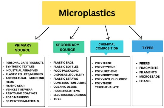
Microplastic (MP) contamination has become a widespread environmental concern in coastal and freshwater wetlands, ecosystems that play a crucial role in hydrological regulation, nutrient cycling, and biodiversity conservation. Despite their ecological importance, research on MPs in wetlands remains fragmented and comparatively underexplored. This
[...] Read more.
Microplastic (MP) contamination has become a widespread environmental concern in coastal and freshwater wetlands, ecosystems that play a crucial role in hydrological regulation, nutrient cycling, and biodiversity conservation. Despite their ecological importance, research on MPs in wetlands remains fragmented and comparatively underexplored. This study presents a comprehensive bibliometric and visualization analysis of global research on MPs in coastal wetlands. A total of 17,523 publications were retrieved from the Web of Science Core Collection (2002–2025) using predefined search strings and screening criteria. Analytical tools, including VOSviewer version 1.6.20, were employed to examine co-authorship networks, country contributions, and keyword co-occurrence patterns. The results indicate a significant increase in MP-related publications after 2016, with China, the United States, and India emerging as leading contributors. However, wetland-specific studies constitute only a small fraction compared to marine-focused MP research, highlighting a substantial research gap. Key research themes identified include MP sources, transport pathways, sediment–water interactions, and ecotoxicological impacts. Additionally, there is growing attention to remediation approaches, particularly those involving TiO2, ZnO, Fe3O4, and graphene derivatives, employing photocatalytic, magnetic, and adsorptive mechanisms. Overall, the findings underscore the limited focus on wetland ecosystems in MP research and emphasize the urgent need for integrated research efforts and management strategies to address MP contamination in these vulnerable ecosystems.
Full article
(This article belongs to the Topic Innovative and Critical Issues in Natural Resource Management and Exploitation)
►▼
Show Figures

Figure 1
Open AccessArticle
Port Digital Twins for Sustainable Urban Futures in Europe
by
Christina N. Tsaimou, Maria Intzeler and Vasiliki K. Tsoukala
Earth 2026, 7(2), 68; https://doi.org/10.3390/earth7020068 - 20 Apr 2026
Abstract
►▼
Show Figures
Ports are increasingly recognized as actors that influence the sustainability of urban environments due to their spatial footprint, operational intensity, and close interaction with surrounding cities. As digital technologies become more embedded in infrastructure management, Digital Twins (DTs) are emerging in port systems
[...] Read more.
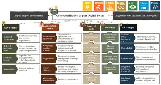
Ports are increasingly recognized as actors that influence the sustainability of urban environments due to their spatial footprint, operational intensity, and close interaction with surrounding cities. As digital technologies become more embedded in infrastructure management, Digital Twins (DTs) are emerging in port systems as tools that can support more integrated and sustainable port–city development. This paper investigates how DT technologies applied in ports can contribute to broader urban sustainability objectives within port–city systems. The analysis is based on a synthesis of documented DT practices from selected European ports. Geographic Information System (GIS) visualization is used to illustrate the spatial relationship between port infrastructure and the surrounding urban environment, as well as to map the connections between DT application fields and relevant Sustainable Development Goals (SDGs). A comparative interpretation of the extent to which DT applications align with urban sustainability goals across the examined ports is achieved through the development of an SDG contribution scale. Insights derived from the European cases are subsequently contextualized for the Port of Piraeus, exploring how similar DT approaches could support both operational efficiency and the long-term climate resilience of the port–city environment. Overall, the findings provide practical insights for port authorities, urban planners, and policymakers seeking to align digital transformation strategies with sustainable and climate-responsive infrastructure development in port–city systems.
Full article

Figure 1
Open AccessArticle
Urban Transformation of the Belgrade Riverfront: Land Use and Vegetation Change from 1990 to 2024
by
Mirjana Miletić, Milena Lakićević and Ana Firanj Sremac
Earth 2026, 7(2), 67; https://doi.org/10.3390/earth7020067 - 17 Apr 2026
Abstract
►▼
Show Figures
Urban districts along major rivers are undergoing rapid transformation, yet long-term evidence on how redevelopment reshapes land cover and vegetation structure remains limited in post-socialist cities. This study examines the spatio-temporal evolution of land use and land cover (LULC) and vegetation dynamics along
[...] Read more.
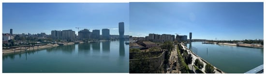
Urban districts along major rivers are undergoing rapid transformation, yet long-term evidence on how redevelopment reshapes land cover and vegetation structure remains limited in post-socialist cities. This study examines the spatio-temporal evolution of land use and land cover (LULC) and vegetation dynamics along the Sava River corridor in Belgrade from 1990 to 2024. CORINE Land Cover (CLC) datasets were combined with Landsat-derived NDVI and MSAVI time series, while high-resolution Esri Wayback imagery was used for visual interpretation and qualitative corroboration of the detected land-cover and vegetation patterns. Beyond conventional NDVI/LULC assessments, the study integrates multi-decadal spectral trends with functional vegetation structure classification to evaluate canopy continuity and ecological configuration under contrasting redevelopment models. Results reveal a pronounced divergence between the two riverbanks. The left bank (New Belgrade) maintains stable land-cover composition and consistently higher NDVI and MSAVI values, indicating preserved green infrastructure and sustained canopy continuity. In contrast, the right bank (Belgrade Waterfront) experienced substantial land-cover conversion after 2006, with a statistically significant decline in vegetation greenness (NDVI −0.020 dec−1, p < 0.001) and a marked increase in impervious surfaces. MSAVI-based functional classes indicate a shift from mixed low vegetation to predominantly sealed land, while tree canopy remained persistently low throughout redevelopment. The findings demonstrate measurable ecological simplification and canopy loss, even where nominal green areas remain present. By providing a rare multi-decadal, spatially explicit comparison of two contrasting planning paradigms within the same river corridor, the study contributes new empirical evidence on how governance and redevelopment models shape riparian ecological trajectories and sustainable urbanism in post-socialist cities. Strengthening blue-green infrastructure and restoring native riparian vegetation are essential for enhancing climate resilience and ensuring long-term riverfront sustainability.
Full article

Figure 1
Journal Menu
► ▼ Journal Menu-
- Earth Home
- Aims & Scope
- Editorial Board
- Reviewer Board
- Topical Advisory Panel
- Instructions for Authors
- Special Issues
- Topics
- Sections
- Article Processing Charge
- Indexing & Archiving
- Editor’s Choice Articles
- Most Cited & Viewed
- Journal Statistics
- Journal History
- Journal Awards
- Conferences
- Editorial Office
Journal Browser
► ▼ Journal BrowserHighly Accessed Articles
Latest Books
E-Mail Alert
News
Topics
Topic in
Atmosphere, Buildings, Climate, Environments, Sustainability, Earth
Climate, Health and Cities: Building Aspects for a Resilient Future
Topic Editors: Ferdinando Salata, Virgilio Ciancio, Simona MannucciDeadline: 25 May 2026
Topic in
Atmosphere, Economies, Energies, Land, Sustainability, Earth, World
Digital Intelligence Leads Environmental Regulation: A New Paradigm for Green Sustainable Development
Topic Editors: Da Gao, Kun DuanDeadline: 20 June 2026
Topic in
Earth, Land, RSEE, Smart Cities, Economies, World, Geographies
Australasian Cities at the Crossroads: Navigating Legacy, Innovation & Sustainability
Topic Editors: Mirko Guaralda, Alessio Russo, Sara Alidoust, Sébastien DarchenDeadline: 30 June 2026
Topic in
Atmosphere, Earth, Encyclopedia, Entropy, Fractal Fract, MAKE, Meteorology
Revisiting Butterfly Effect, Multiscale Dynamics, and Predictability Using Ai-Enhanced Modeling Framework (AEMF) and Chaos Theory
Topic Editors: Bo-Wen Shen, Roger A. Pielke Sr., Xubin ZengDeadline: 31 July 2026
Conferences
Special Issues
Special Issue in
Earth
Special Issue Series: Young Investigators in Earth Science
Guest Editor: Charles JonesDeadline: 31 July 2026
Special Issue in
Earth
Integrated Coastal Resilience and Risk Management Under Climate Change
Guest Editors: Komali Kantamaneni, Upaka RathnayakeDeadline: 31 August 2026
Special Issue in
Earth
Smart and Precision Farming for Climate-Resilient Water and Land Management
Guest Editors: Dimitrios E. Tsesmelis, Pantelis E. Barouchas, Georgios Bourantas, Kleomenis KalogeropoulosDeadline: 1 October 2026
Special Issue in
Earth
Sustainable Landscapes: Integrating Physical Geography, Ecotourism, and Nature Conservation
Guest Editors: Sanja Obradović Strålman, Nikola Milentijević, Ioannis CharalampopoulosDeadline: 31 October 2026