The Tropical Cyclones Portal

A tropical cyclone is a storm system characterized by a large low-pressure center, a closed low-level circulation and a spiral arrangement of numerous thunderstorms that produce strong winds and heavy rainfall. Tropical cyclones feed on the heat released when moist air rises, resulting in condensation of water vapor contained in the moist air. They are fueled by a different heat mechanism than other cyclonic windstorms such as Nor'easters, European windstorms and polar lows, leading to their classification as "warm core" storm systems. Most tropical cyclones originate in the doldrums, approximately ten degrees from the Equator.
The term "tropical" refers to both the geographic origin of these systems, which form almost exclusively in tropical regions of the globe, as well as to their formation in maritime tropical air masses. The term "cyclone" refers to such storms' cyclonic nature, with anticlockwise rotation in the Northern Hemisphere and clockwise rotation in the Southern Hemisphere. Depending on its location and intensity, a tropical cyclone may be referred to by names such as "hurricane", "typhoon", "tropical storm", "cyclonic storm", "tropical depression" or simply "cyclone".
Types of cyclone: 1. A "Typhoon" is a tropical cyclone located in the North-west Pacific Ocean which has the most cyclonic activity and storms occur year-round. 2. A "Hurricane" is also a tropical cyclone located at the North Atlantic Ocean or North-east Pacific Ocean which have an average storm activity and storms typically form between May 15 and November 30. 3. A "Cyclone" is a tropical cyclone that occurs in the South Pacific and Indian Oceans.
Selected named cyclone -

Hurricane Bud was a tropical cyclone that brought winds and severe flooding to Mexico throughout its existence as a tropical cyclone in June 2018. It was the second named storm, hurricane, and major hurricane of the 2018 Pacific hurricane season.[1] Bud originated from a tropical wave that departed from Western Africa on May 29. It traveled across the Atlantic Ocean before entering the Northeast Pacific Ocean late on June 6. The system moved towards the northwest and steadily organized, becoming a tropical depression on June 9 and Tropical Storm Bud early the next day. Favorable upper-level winds, ample moisture aloft, and warm sea surface temperatures allowed the storm to rapidly intensify to a hurricane late on June 10, and further to a major hurricane on the following day. Bud ultimately peaked the next morning with maximum sustained winds of 140 mph (230 km/h) and a minimum central pressure of 943 mbar (943 hPa; 27.8 inHg). Its track curved more northward while the storm rapidly succumbed to the effects of upwelling. Bud made landfall on Baja California Sur as a minimal tropical storm early on June 15. On the next day, land interaction and increasing wind shear caused Bud to degenerate into a post-tropical cyclone. It opened up into a trough of low-pressure on June 16. The remnants of Bud moved towards the Southwestern United States, bringing tropical moisture and gusty winds to the region.
Bud prompted the issuance of multiple watches and warnings for Baja California Sur and western and central Mexico. Bud caused two deaths in Mexico; one in Mexico City and another in Baja California Sur. The storm also caused a damage of US$478,000. Despite remaining offshore for most of its track, the hurricane caused torrential rainfall and severe flooding in several regions. A peak rainfall total of 6.50 in (165 mm) was recorded in San Lorenzo, Sinaloa. In Guadalajara, Jalisco, hundreds of vehicles were inundated and swept away. A canal overflowed in Guadalajara, causing damage to multiple stores in a mall. At least 100 additional structures were damaged in the city. In Guerrero, hundreds of businesses and homes were flooded. Over 100 businesses in Pie de la Cuesta were damaged by strong waves. More than 60 homes in Maruata, Michoacan, experienced flood or wind damage. Severe flooding along a street in Mexico City inundated dozens of vehicles, necessitating the rescue of their passengers. Rains from Bud's remnants brought relief to drought-stricken areas and slowed the growth of wildfires in Wyoming and Colorado. The influx of moisture prompted the issuance of flash flood watches for Colorado and New Mexico, and caused flooding near Cave Creek, Arizona. (Full article...)
Selected article -

Hurricane Dennis lasted twenty-two days, beginning with its inception as a tropical wave over Africa on June 26, 2005, and terminating with its dissipation on July 18 over the Great Lakes of North America. The incipient wave that became Dennis emerged over the Atlantic Ocean on June 29 and moved briskly to the west. Dry air initially inhibited development, though once this abated the wave was able to consolidate into a tropical depression on July 4. The depression soon crossed Grenada before entering the Caribbean whereupon increasingly favorable environmental factors, such as low wind shear and high sea surface temperatures, fueled intensification. Turning west-northwest, the system achieved tropical storm status on July 5 and hurricane status the following day.
Formation of a well-defined eye and central dense overcast signaled Dennis's intensification into a major hurricane. The powerful storm soon struck Granma Province, Cuba, as a Category 4 early on July 8; violent winds battered the province and caused extensive damage. Paralleling the western coast of Cuba, Dennis attained its peak winds of 150 mph (240 km/h) later that day before making a second landfall in the country, this time in Matanzas Province. Interaction with the mountains of Cuba caused significant weakening; however, once Dennis emerged over the Gulf of Mexico on July 9, it was able to quickly reorganize. The hurricane reached Category 4 strength for a third time on July 10 as it approached Florida, weakening somewhat before striking the state. Dramatic weakening ensued once the cyclone moved ashore. Dennis lingered as a tropical depression and remnant low for roughly a week, traversing the Mississippi River Valley and the Ohio River Valley before finally dissipating over Ontario on July 18. (Full article...)
Selected image -

Selected season -

The 2009 North Indian Ocean cyclone season was an average season in terms of the number of cyclonic storms, however the storms were mostly weak in nature. It was the first season since 2005 wherein a storm did not strength above severe cyclonic storm status. The North Indian Ocean cyclone season has no official bounds, but cyclones tend to form between April and December, with peaks in May and November. These dates conventionally delimit the period of each year when most tropical cyclones form in the northern Indian Ocean.
The scope of this article is limited to the Indian Ocean in the Northern Hemisphere, east of the Horn of Africa and west of the Malay Peninsula. There are two main seas in the North Indian Ocean — the Arabian Sea to the west of the Indian subcontinent, abbreviated ARB by the India Meteorological Department (IMD); and the Bay of Bengal to the east, abbreviated BOB by the IMD. (Full article...)
Related portals
Currently active tropical cyclones

Italicized basins are unofficial.
- North Atlantic (2025)
- No active systems
- Mediterranean (2025–26)
- No active systems
- South-West Indian Ocean (2025–26)
- No active systems
- Australian region (2025–26)
- No active systems
- South Pacific (2025–26)
- No active systems
- South Atlantic (2025–26)
- No active systems
Last updated: 21:32, 5 October 2025 (UTC)
Tropical cyclone anniversaries

October 4
- 1995 - Hurricane Opal made landfall on the Florida panhandle with 185 km/h (115 mph) winds. Opal caused over $3 billion of damage in Florida alone.
- 2016 - Hurricane Matthew (pictured) affects the Caribbean as a Category 4 major hurricane, where more than 1,000 people were killed and damages recorded nearly about $15 billion.

October 5
- 1864 - The 1864 Calcutta cyclone hit India near Calcutta, devastating the city and killing about 60,000 people.
- 1999 - Typhoon Dan reaches its maximum intensity as a Category 3 typhoon with 10-minute sustained winds of 150 km/h (90 mph)
- 2003 - Tropical Storm Larry (pictured) makes landfall over in Paraíso, Tabasco. Damages from Larry were recorded at $53.6 million.

October 6
- 1973 - Typhoon Nora reached its peak intensity with 295 km/h (185 mph) winds in the Philippine Sea. Nora made landfall in northeast Luzon a few days later, causing $2 billion of damage.
- 1989 - Typhoon Angela makes landfall over in northern Luzon, Philippines and killing a total of 119.
- 2013 - Typhoon Fitow (pictured) makes landfall in Fujian, causing $10.4 billion in damages, making it the third costliest typhoon on record.
Did you know…


- …that the Australian region have three distinct lists of names for tropical storms, each one of them being administered by agencies in Autralia, Indonesia and Papua New Guinea, respectively?
- …that the Joint Typhoon Warning Center considers that Typhoon Vera (pictured) of 1986 is actually two distinct systems, formed from two separated low-level circulations?
- …that Cyclone Freddy (track pictured) in 2023 was the longest-lasting tropical cyclone recorded?
- …that the typhoons of 2024—Yinxing, Toraji, Usagi, and Man-yi (pictured)—made history as the first recorded instance since 1951 of four tropical cyclones coexisting in November?
General images -
-

-
 The aftermath of Hurricane Katrina in Gulfport, Mississippi. Katrina was the costliest tropical cyclone in United States history. (from Effects of tropical cyclones)
 -
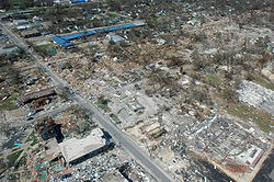
 Aerial image of destroyed houses in Tacloban, following Typhoon Haiyan (from Effects of tropical cyclones)
 -
 Cyclone on Mars, imaged by the Hubble Space Telescope (from Cyclone)
 -
 A fictitious synoptic chart of an extratropical cyclone affecting the UK and Ireland. The blue arrows between isobars indicate the direction of the wind, while the "L" symbol denotes the centre of the "low". Note the occluded, cold and warm frontal boundaries. (from Cyclone)
 -
 The dangerous semicircle is the upper-right corner, with the arrow marking the direction of motion of a Northern Hemisphere storm. Note that typhoons, etc. are asymmetrical, and semicircle is a convenient misnomer. (from Effects of tropical cyclones)
 -
-
 An example of a chart for Matthew showing its five-day forecast track (from Tropical cyclone preparedness)
 -
 A polar low over the Sea of Japan in December 2009 (from Cyclone)
 -
 Tropical cyclones form when the energy released by the condensation of moisture in rising air causes a positive feedback loop over warm ocean waters. (from Cyclone)
 -
 The initial extratropical low-pressure area forms at the location of the red dot on the image. It is usually perpendicular (at a right angle to) the leaf-like cloud formation seen on satellite during the early stage of cyclogenesis. The location of the axis of the upper level jet stream is in light blue. (from Cyclone)
 -
 Hurricane Isabel (2003)'s effect on the North Carolina Outer Banks (from Effects of tropical cyclones)
 -
 All but the most expensive bottles of water were sold out at this Publix supermarket before Hurricane Irma; in the week preceding the storm, water sold out soon after shipments arrived (from Tropical cyclone preparedness)
 -
 Personnel and equipment from the National Guard of the United States en route to Hurricane Florence response efforts in 2018
 -
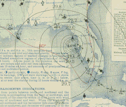 Surface weather map of the 1935 Labor Day hurricane moving up the west coast of Florida (from Tropical cyclone observation)
 -
 Flooding in Port Arthur, Texas caused by Hurricane Harvey. Harvey was the wettest and second-costliest tropical cyclone in United States history. (from Effects of tropical cyclones)
 -

-
 Hurricane response involves working in hazardous conditions, including contamination and electrocution hazards from floodwater.
 -
 Comparison between extratropical and tropical cyclones on surface analysis (from Cyclone)
 -
 Broken concrete utility pole in Puerto Rico after Hurricane Maria in 2017, which ranks fourth in costliest US tropical cyclones. (from Effects of tropical cyclones)
 -
 Chart with concurrent information for Hurricane Arlene and Tropical Storm Bret logged and plotted (from Tropical cyclone preparedness)
 -
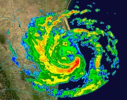 Radar image of Hurricane Erika making landfall over Northeastern Mexico (from Tropical cyclone observation)
 -
 An extratropical cyclone near Iceland (from Cyclone)
 -
 Percentages of hurricane deaths in the United States from 1970 to 1999. (from Effects of tropical cyclones)
 -
 The number of $1 billion Atlantic hurricanes almost doubled from the 1980s to the 2010s, and inflation-adjusted costs have increased more than elevenfold. The increases have been attributed to climate change and to greater numbers of people moving to coastal areas. (from Effects of tropical cyclones)


.jpg)

_(50).jpg)
_(cropped).jpg)
.jpg)


 Featured list -
Tropical cyclones and subtropical cyclones are named by various warning centers to simplify communication between forecasters and the general public regarding forecasts, watches and warnings. The names are intended to reduce confusion in the event of concurrent storms in the same basin. Once storms develop sustained wind speeds of more than 33 knots (61 km/h; 38 mph), names are generally assigned to them from predetermined lists, depending on the basin in which they originate. Some tropical depressions are named in the Western Pacific, while tropical cyclones must contain a significant amount of gale-force winds before they are named in the Southern Hemisphere.
Before it became standard practice to give personal (first) names to tropical cyclones, they were named after places, objects, or the saints' feast days on which they occurred. Credit for the first usage of personal names for weather systems is generally given to Queensland Government meteorologist Clement Wragge, who named systems between 1887 and 1907. When Wragge retired, the practice fell into disuse for several years until it was revived in the latter part of World War II for the Western Pacific. Formal naming schemes and lists have subsequently been used for major storms in the Eastern, Central, Western and Southern Pacific basins, and the Australian region, Atlantic Ocean and Indian Ocean. (Full article...)
Topics
Subcategories

Related WikiProjects
WikiProject Tropical cyclones is the central point of coordination for Wikipedia's coverage of tropical cyclones. Feel free to help!
WikiProject Weather is the main center point of coordination for Wikipedia's coverage of meteorology in general, and the parent project of WikiProject Tropical cyclones. Three other branches of WikiProject Weather in particular share significant overlaps with WikiProject Tropical cyclones:
- The Non-tropical storms task force coordinates most of Wikipedia's coverage on extratropical cyclones, which tropical cyclones often transition into near the end of their lifespan.
- The Floods task force takes on the scope of flooding events all over the world, with rainfall from tropical cyclones a significant factor in many of them.
- WikiProject Severe weather documents the effects of extreme weather such as tornadoes, which landfalling tropical cyclones can produce.
Things you can do
 |
Here are some tasks awaiting attention:
|
Wikimedia
The following Wikimedia Foundation sister projects provide more on this subject:
-
 Commons
Free media repository -
 Wikibooks
Free textbooks and manuals -
 Wikidata
Free knowledge base -
 Wikinews
Free-content news -
 Wikiquote
Collection of quotations -
 Wikisource
Free-content library -
 Wikiversity
Free learning tools -
 Wikivoyage
Free travel guide -
 Wiktionary
Dictionary and thesaurus


- ^ National Hurricane Center; Hurricane Research Division; Central Pacific Hurricane Center (April 26, 2024). "The Northeast and North Central Pacific hurricane database 1949–2023". United States National Oceanic and Atmospheric Administration's National Weather Service. Archived from the original on May 29, 2024. A guide on how to read the database is available here.
 This article incorporates text from this source, which is in the public domain.