
| This is a Wikipedia user page. This is not an encyclopedia article or the talk page for an encyclopedia article. If you find this page on any site other than Wikipedia, you are viewing a mirror site. Be aware that the page may be outdated and that the user whom this page is about may have no personal affiliation with any site other than Wikipedia. The original page is located at https://en.wikipedia.org/wiki/User:Olahus. |

Beliefs
|

| |||
Hi! I am the user Olahus. I am interested in the history and geography of Central, Eastern and Southeastern Europe.
I am a registered user since May 2006.

Albert Marco was an Italian-born bootlegger and pimp active in Los Angeles during the American Prohibition era. Born around 1887, he immigrated into the United States in the early 20th century and became involved in crime in Nevada and Washington before moving to Southern California. Protected by political connections, Marco made large profits from liquor smuggling and prostitution, and was linked to figures including Charles H. Crawford and Max "Boo Hoo" Hoff. In 1928 he was arrested after shooting two men at the Ship Cafe in Venice, Los Angeles. Convicted of assault with a deadly weapon, he was sent to San Quentin State Prison, and was eventually deported to Italy. This photograph, showing Marco at the police station with blood stains, was captured on a glass-plate negative by a Los Angeles Times photographer the morning after a Ship Cafe shooting.Photograph credit: unidentified Los Angeles Times photographer; restored by Adam Cuerden
Images uploaded by me
editMaps created by me
edit
.PNG)
.PNG)
.PNG)
.PNG)
.PNG)


.png)

.PNG)
.PNG)
.PNG)


.PNG)


Scanned images
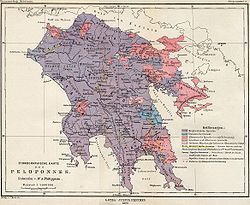
edit Ethnic map of the Balkan Peninsula (1898)
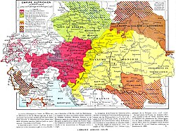 The Austrian Empire during the XVII century
 The Carolingian Empire after the Treaty of Verdun
 Ethnic map of European Russia before the First World War
 Ethnographic map of Dobruja (1918)
 The Principality of Montenegro in 1862
 Major Lithuanian linguistic areal in 1876.
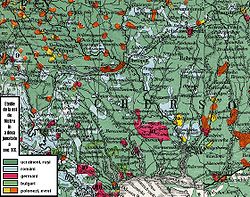
 Ethnic Germans in Hungary and parts of adjacent Austrian territories, census 1890
 Demographic map of Italy and surroundung regions (1859)
 Linguistic map of Slovenia and surrounding regions (census 1880)
 Linguistic map of Istria (census 1880)
 The Romanian Old Kingdom (1901)
 Bulgaria in 1901
 General map of Rumania (1967)
 Confessions in Central Europe
 Bukovina in 1901
 Political map of Europe (1899)
 Political map of Asia (1899)
 Main subdivisions of Austria-Hungary (1899).
 Political map of South America (1899)
 Extermination of the American Bison to 1889
 The density of the railway net in Europe (1902)
 Map of Greece and European Turkey (1829)
 The United States in 1829
 Europe in 1828
 Austria-Hungary in 1828
 The German confederation (1828)
 The Ottoman Empire in Asia (1829)
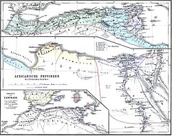
 The American continent in 1828
 Africa in 1828
 Asia in 1829
 The Russian Empire in 1828
 The world map (1829)
 Historical map of Switzerland
 The Lake Lucerne (1829)


 Ethnographic map of the Epirus region, 1878. Greek point of view
 Walser settlements in northwestern Italy


.JPG)

.JPG)


.jpg)
.JPG)


.JPG)


.JPG)
.jpg)
.JPG)


.JPG)


_1892.JPG)

.JPG)
.jpg)

.JPG)


.jpg)

.JPG)

.jpg)


.JPG)
.jpg)

.jpg)
.jpg)


.jpg)


.JPG)


