Godiva Mine (Godiva Shaft), Knightville, Tintic Mining District, East Tintic Mountains, Utah, USAi
| Regional Level Types | |
|---|---|
| Godiva Mine (Godiva Shaft) | Mine |
| Knightville | Town |
| Tintic Mining District | - not defined - |
| East Tintic Mountains | Mountain Range |
| Utah | State |
| USA | Country |
Godiva Mine (Godiva Shaft), Knightville, Tintic Mining District, East Tintic Mountains, Tintic Mining District, East Tintic Mountains, Juab County, Utah, USA
This page is currently not sponsored. Click here to sponsor this page.


Latitude & Longitude (WGS84):
39° 57' 5'' North , 112° 6' 11'' West
Latitude & Longitude (decimal):
Type:
Köppen climate type:
Nearest Settlements:
| Place | Population | Distance |
|---|---|---|
| Eureka | 666 (2017) | 1.5km |
| Mount Nebo | 302 (2006) | 12.5km |
| Elberta | 256 (2011) | 12.8km |
| Goshen | 944 (2017) | 17.3km |
| Genola | 1,419 (2017) | 22.7km |
Nearest Clubs:
Local clubs are the best way to get access to collecting localities
Local clubs are the best way to get access to collecting localities
| Club | Location | Distance |
|---|---|---|
| Timpanogos Gem & Mineral Society | Provo, Utah | 49km |
Location and Description
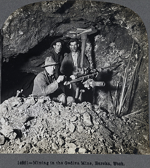
The Godiva Mine lies on the north eastern slopes of Godiva Mountain, and is opened by a shaft and tunnel. The collar of the shaft is at an elevation of 7,025 feet, and is 900 feet deep with 9 levels (probably turned every 100 feet). The Godiva Mine also connects with the nearby Tetro Mine via a connection on the 500 foot level. The connection consists of a 1,300 foot long tunnel that ascends 200 feet towards the Tetro Mine, where there is a 500 foot vertical shaft that ascends to the main Tetro tunnel.
Workings and Ore
The ore was largely oxidized, and mainly consisted of cerussite, anglesite, and galena, with small amounts of silver averaging 9 ounces a ton. The ore bodies follow northerly trending fractures in the Limestone, with several offsets along local cross fractures. On the 100 foot level there are stopes that extend nearly continuously for 300 feet north and 500 feet south of the shaft, trending a few degrees northeast-southwest, with a width of 30-40 feet. The ore bodies found on the 200, 400, and 500 foot levels are smaller than on the 100 foot level. On the 200 and 400 foot levels, irregular ore bodies were discovered 100 and 400 feet west of the shaft, respectively.
Geology
There is a rhyolite-limestone contact very close to the collar of the Godiva shaft. All of the lower slopes of Godiva mountain are covered by rhyolite. On the 200, 500, and 600 foot levels, the same rhyolite-limestone contact is exposed. The rest of the workings in the mine are in the Pine Canyon limestone, with principle fractures striking North 30° west, wheras the limestone has a strike of north 15° west. On the Godiva tunnel level, which is the 200 foot level of the shaft, the contact with the rhyolite is sharp, vertical, and somewhat overhanging. The rhyolite is clayey, with a lot of fine grained pyrite and gypsum. The contact also adjoins a mass of limestone detritus, with its coarse fragments being distinctly oxidized. Very little mineralization occurred in the contact, but 25 feet away, in a limestone fracture, small amounts of ore were discovered. On the 600 foot level, a pipe of fragmental rhyolite appeared in the limestone. On this same level, the contact is thought to be exposed, but very little rhyolite was actually found.
Select Mineral List Type
Standard Detailed Gallery Strunz Chemical ElementsMineral List
Mineral list contains entries from the region specified including sub-localities6 valid minerals.
Detailed Mineral List:
| ⓘ Anglesite Formula: PbSO4 |
| ⓘ Cerussite Formula: PbCO3 |
| ⓘ Chlorargyrite Formula: AgCl |
| ⓘ Galena Formula: PbS |
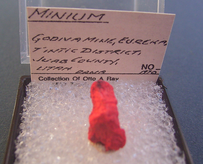
| ⓘ Minium Formula: Pb3O4 References: |
| ⓘ Smithsonite Formula: ZnCO3 |
Gallery:
List of minerals arranged by Strunz 10th Edition classification
| Group 2 - Sulphides and Sulfosalts | |||
|---|---|---|---|
| ⓘ | Galena | 2.CD.10 | PbS |
| Group 3 - Halides | |||
| ⓘ | Chlorargyrite | 3.AA.15 | AgCl |
| Group 4 - Oxides and Hydroxides | |||
| ⓘ | Minium | 4.BD.05 | Pb3O4 |
| Group 5 - Nitrates and Carbonates | |||
| ⓘ | Smithsonite | 5.AB.05 | ZnCO3 |
| ⓘ | Cerussite | 5.AB.15 | PbCO3 |
| Group 7 - Sulphates, Chromates, Molybdates and Tungstates | |||
| ⓘ | Anglesite | 7.AD.35 | PbSO4 |
List of minerals for each chemical element
| C | Carbon | |
|---|---|---|
| C | ⓘ Cerussite | PbCO3 |
| C | ⓘ Smithsonite | ZnCO3 |
| O | Oxygen | |
| O | ⓘ Anglesite | PbSO4 |
| O | ⓘ Cerussite | PbCO3 |
| O | ⓘ Minium | Pb3O4 |
| O | ⓘ Smithsonite | ZnCO3 |
| S | Sulfur | |
| S | ⓘ Anglesite | PbSO4 |
| S | ⓘ Galena | PbS |
| Cl | Chlorine | |
| Cl | ⓘ Chlorargyrite | AgCl |
| Zn | Zinc | |
| Zn | ⓘ Smithsonite | ZnCO3 |
| Ag | Silver | |
| Ag | ⓘ Chlorargyrite | AgCl |
| Pb | Lead | |
| Pb | ⓘ Anglesite | PbSO4 |
| Pb | ⓘ Cerussite | PbCO3 |
| Pb | ⓘ Galena | PbS |
| Pb | ⓘ Minium | Pb3O4 |
Localities in this Region
- Utah
- East Tintic Mountains
- Tintic Mining District
- Knightville
- Godiva Mine (Godiva Shaft)
- Knightville
- Tintic Mining District
- East Tintic Mountains
Other Regions, Features and Areas containing this locality
North AmericaContinent
North America PlateTectonic Plate
- Basin and Range BasinsBasin
- Mojave DomainDomain
- Northern Basin and RangeWide Rift
- Oquirrh BasinBasin
USA
- Utah
- East Tintic MountainsMountain Range
- Juab County
- East Tintic Mountains
- Tintic Mining DistrictMining District
- East Tintic Mountains
- Western Phosphate fieldMineral Province
This page contains all mineral locality references listed on mindat.org. This does not claim to be a complete list. If you know of more minerals from this site, please register so you can add to our database. This locality information is for reference purposes only. You should never attempt to
visit any sites listed in mindat.org without first ensuring that you have the permission of the land and/or mineral rights holders
for access and that you are aware of all safety precautions necessary.
Godiva Mine, Knightville, Tintic Mining District, East Tintic Mountains, Utah, USA