Ostrhauderfehn
Ostrhauderfehn | |
|---|---|
) Coat of arms | |
Location of Ostrhauderfehn within Leer district 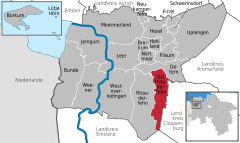 | |
)  Ostrhauderfehn ) Ostrhauderfehn | |
| Coordinates: 53°07′N 07°37′E / 53.117°N 7.617°E | |
| Country | Germany |
| State | Lower Saxony |
| District | Leer |
| Government | |
| • Mayor | Günter Harders (Ind.) |
| Area | |
| • Total | 51.00 km2 (19.69 sq mi) |
| Elevation | 3 m (10 ft) |
| Population (2019-12-31)[1] | |
| • Total | 11,318 |
| • Density | 220/km2 (570/sq mi) |
| Time zone | UTC+01:00 (CET) |
| • Summer (DST) | UTC+02:00 (CEST) |
| Postal codes | 26842 |
| Dialling codes | 0 49 52 |
| Vehicle registration | LER |
| Website | www.ostrhauderfehn.de |
Ostrhauderfehn is a municipality in the Leer district of Lower Saxony, Germany.
It split from Rhauderfehn sometime between 1820 and 1830. Ostrhauderfehn was for many years one of the largest municipalities in the district of Leer.
References
This article is copied from an article on Wikipedia® - the free encyclopedia created and edited by its online user community. The text was not checked or edited by anyone on our staff. Although the vast majority of Wikipedia® encyclopedia articles provide accurate and timely information, please do not assume the accuracy of any particular article. This article is distributed under the terms of GNU Free Documentation License.