Geography (from Ancient Greekγεωγραφίαgeōgraphía; combining gê 'Earth' and gráphō 'write', literally 'Earth writing') is the study of the lands, features, inhabitants, and phenomena of Earth. Geography is an all-encompassing discipline that seeks an understanding of Earth and its human and natural complexities—not merely where objects are, but also how they have changed and come to be. While geography is specific to Earth, many concepts can be applied more broadly to other celestial bodies in the field of planetary science. Geography has been called "a bridge between natural science and social science disciplines."
The history of geography as a discipline spans cultures and millennia, being independently developed by multiple groups, and cross-pollinated by trade between these groups. Geography as a discipline dates back to the earliest attempts to understand the world spatially, with the earliest example of an attempted world map dating to the 9th century BCE in ancient Babylon. Origins of many of the concepts in geography can be traced to Greek Eratosthenes of Cyrene, who may have coined the term "geographia" (c. 276 BC – c. 195/194 BC). The first recorded use of the word γεωγραφία was as the title of a book by Greek scholar Claudius Ptolemy (100 – 170 AD). During the Middle Ages, geography was influenced by Islamic scholars, like Muhammad al-Idrisi, producing detailed maps of the world. The Age of Discovery was influential in the development of geography, as European explorers mapped the New World. Modern developments include the development of geomatics and geographic information science.
The core concepts of geography consistent between all approaches are a focus on space, place, time, and scale. Today, geography is an extremely broad discipline with multiple approaches and modalities. The main branches of geography are physical geography, human geography, and technical geography. Physical geography focuses on the natural environment, human geography focuses on how humans interact with the Earth, and technical geography focuses on the development of tools for understanding geography. Techniques employed can generally be broken down into quantitative and qualitative approaches, with many studies taking mixed-methods approaches. Common techniques include cartography, remote sensing, interviews, and surveying. (Full article...)
This stretch of coast originally consisted of salt marshes protected from the sea by ridges of shingle and sand, and Holkham's Iron Age fort stood at the end of a sandy spit surrounded by the tidal wetland. The Vikings navigated the creeks to establish Holkham village, but access to the former harbour was stopped by drainage and reclamation of the marshes between the coast and the shingle ridge which started in the 17th century, and was completed in 1859. The Holkham estate has been owned by the Coke family, later Earls of Leicester since 1609, and their seat at Holkham Hall is opposite the reserve's Lady Anne's Drive entrance. The 3rd Earl planted pines on the dunes to protect the pastures reclaimed by his predecessors from wind-blown sand. The national nature reserve was created in 1967 from 1,700 hectares (4,200 acres) of the Holkham Estate and 2,200 hectares (5,400 acres) of foreshore belonging to the Crown. (Full article...)
Image 2
Der Überfall bei Hochkirch am 14. Oktober 1758, Hyacinthe de la Pegna
Historians generally consider the battle as among Frederick's greatest blunders. Contrary to the advice of his subordinates, he refused to believe that the typically cautious Austrian commander Leopold von Daun would bring his troops into battle. The Austrian force ambushed his army in a pre-dawn attack. Over 30% of Frederick's army was defeated; five generals were killed, and he lost his artillery park and a vast quantity of supplies. Although Daun had scored a complete surprise, his attempt to pursue the retreating Prussians was unsuccessful. The escaped force united with another corps in the vicinity and regained momentum over the winter. (Full article...)
Image 3
1879 portrait
José Maria da Silva Paranhos, Viscount of Rio Branco (16 March 1819 – 1 November 1880), was a Brazilian politician, monarchist, diplomat, teacher and journalist. Rio Branco was born in Salvador, in what was then the Captaincy of Bahia, to a wealthy family, but most of the fortune was lost after his parents' deaths early in his childhood. In 1871, Rio Branco became the president of the Council of Ministers. He would be the Council's longest-serving president, and his cabinet the second longest, in Brazilian history. His government was marked by economic prosperity and several reforms. The most important of these initiatives was the Law of Free Birth, which granted freeborn status to children born to slave women. Rio Branco led the government that enacted this law, and its passage increased his popularity. His government was plagued by a long crisis with the Catholic Church that resulted from the expulsion of Freemasons from its lay brotherhoods. After more than four years heading the Cabinet, Rio Branco resigned in 1875. Following a long vacation in Europe, his health swiftly declined and he was diagnosed with oral cancer. Rio Branco died in 1880 and was widely mourned throughout the country. He is regarded by most historians as one of Brazil's greatest statesmen.
Rio Branco attended Brazil's Naval School and became a midshipman in 1841. Later that year he was enrolled in the Army's Military Academy, eventually becoming an instructor there. Rather than continue to serve in the military, he became a politician in the Liberal Party. In 1845, he was elected a member of the provincial house of representatives of Rio de Janeiro province, site of the national capital of the same name. Rio Branco rose to power within the province under the tutelage of Aureliano Coutinho, Viscount of Sepetiba—a veteran politician who held tremendous influence over the young and inexperienced Emperor Pedro II. He temporarily abandoned politics after Aureliano Coutinho's fall from grace and the subsequent dissolution of the Liberal Party. (Full article...)
Mount Price is a small stratovolcano in the Garibaldi Ranges of the Pacific Ranges in southwestern British Columbia, Canada. It has an elevation of 2,049 metres (6,722 feet) and rises above the surrounding landscape on the western side of Garibaldi Lake in New Westminster Land District. The mountain contains a number of subfeatures, including Clinker Peak on its western flank, which was the source of two thick lava flows between 15,000 and 8,000 years ago that ponded against glacial ice. These lava flows are structurally unstable, having produced large landslides as recently as the 1850s. A large provincial park surrounds Mount Price and other volcanoes in its vicinity. It lies within an ecological region that surrounds much of the Pacific Ranges.
Mount Price is associated with a small group of volcanoes called the Garibaldi Lake volcanic field. This forms part of the larger Garibaldi Volcanic Belt, a north−south trending volcanic zone that represents a portion of the Canadian Cascade Arc. Mount Price began its formation 1.2million years ago and continued intermittently until sometime in the last 15,000 years. Although the mountain is not known to have been volcanically active for thousands of years, it could erupt again, which would potentially endanger the nearby populace. If this were to happen, relief efforts could be organized by teams such as the Interagency Volcanic Event Notification Plan who are prepared to notify people threatened by volcanic eruptions in Canada. (Full article...)
Image 5
Waterfall in Macleay Park
Balch Creek is a 3.5-mile (5.6 km) tributary of the Willamette River in the U.S. state of Oregon. Beginning at the crest of the Tualatin Mountains (West Hills), the creek flows generally east down a canyon along Northwest Cornell Road in unincorporated Multnomah County and through the Macleay Park section of Forest Park, a large municipal park in Portland. At the lower end of the park, the stream enters a pipe and remains underground until reaching the river. Danford Balch, after whom the creek is named, settled a land claim along the creek in the mid-19th century. After murdering his son-in-law, he became the first person legally hanged in Oregon.
Basalt, mostly covered by silt in the uplands and sediment in the lowlands, underlies the Balch Creek watershed. The upper part of the watershed includes private residential land, the Audubon Society of Portland nature sanctuary, and part of Forest Park. Mixed conifer forest of Coast Douglas-fir, western redcedar, and western hemlock with a well-developed understory of shrubs and flowering plants is the natural vegetation. Sixty-two species of mammals and more than 112 species of birds use Forest Park. A small population of coastal cutthroat trout resides in the stream, which in 2005 was the only major water body in Portland that met state standards for bacteria, temperature, and dissolved oxygen. (Full article...)
Image 6
Combe Hill is a causewayed enclosure, near Eastbourne in East Sussex, on the northern edge of the South Downs. It consists of an inner circuit of ditches and banks, incomplete where it meets a steep slope on its north side, and the remains of an outer circuit. Causewayed enclosures were built in England from shortly before 3700 BC until at least 3500 BC; they are characterized by the full or partial enclosure of an area with ditches that are interrupted by gaps, or causeways. Their purpose is not known; they may have been settlements, meeting places, or ritual sites. The historian Hadrian Allcroft included the site in his 1908 book Earthwork of England, and in 1930 E. Cecil Curwen listed it as a possible Neolithic site in a paper which attempted to provide the first list of all the causewayed enclosures in England.
The enclosure has been excavated twice: in 1949, by Reginald Musson, and in 1962, by Veronica Seton-Williams, who used it as a training opportunity for volunteers. Charcoal fragments from Musson's dig were later dated to between 3500 and 3300 BC. Musson also found a large quantity of Ebbsfleet ware pottery in one of the ditches. Seton-Williams found three polished stone axes deposited in another ditch, perhaps not long after it had been dug. The site is only 800 m (870 yd) from Butts Brow, another Neolithic enclosure, and the two locations are visible from each other; both sites may have seen Neolithic activity at the same time. (Full article...)
Image 7
A hot windstorm brings dust from the surrounding desert, July 3, 1942
Manzanar is the site of one of ten American concentration camps, where more than 120,000 Japanese Americans were incarcerated during World War II, from March 1942 to November 1945. Although it had over 10,000 inmates at its peak, Manzanar was one of the smaller internment camps. It is located in California's Owens Valley, on the eastern side of the Sierra Nevada mountains, between the towns of Lone Pine to the south and Independence to the north, approximately 230 miles (370 km) north of Los Angeles. Manzanar means "apple orchard" in Spanish. The Manzanar National Historic Site, which preserves and interprets the legacy of Japanese American incarceration in the United States, was identified by the United States National Park Service as the best-preserved of the ten former camp sites.
The first Japanese Americans arrived at Manzanar in March 1942, just one month after President Franklin D. Roosevelt signed Executive Order 9066, to build the camp their families would be staying in. Manzanar was in operation as an internment camp from 1942 until 1945. Since the last of those incarcerated left in 1945, former detainees and others have worked to protect Manzanar and to establish it as a National Historic Site to ensure that the history of the site, along with the stories of those who were incarcerated there, is recorded for current and future generations. The primary focus is the Japanese American incarceration era, as specified in the legislation that created the Manzanar National Historic Site. The site also interprets the former town of Manzanar, the ranch days, the settlement by the Owens Valley Paiute, and the role that water played in shaping the history of the Owens Valley. (Full article...)
Image 8
Bryce Canyon National Park (/braɪs/) is a national park of the United States located in southwestern Utah. The major feature of the park is Bryce Canyon, which despite its name, is not a canyon but a collection of giant natural amphitheaters along the eastern side of the Paunsaugunt Plateau. Bryce is distinctive due to geological structures called hoodoos, formed by frost weathering and stream erosion of the river and lake bed sedimentary rock. The red, orange, and white colors of the rocks provide distinctive views for park visitors. Bryce Canyon National Park is much smaller and sits at a much higher elevation than nearby Zion National Park. The rim at Bryce varies from 8,000 to 9,000 feet (2,400 to 2,700 m).
The area is in portions of Garfield County and Kane County. It was settled by Mormon pioneers in the 1850s and was named after Ebenezer Bryce, who homesteaded in the area in 1874. The area was originally designated as a national monument by President Warren G. Harding in 1923 and was redesignated as a national park by Congress in 1928. The park covers 35,835 acres (55.992 sq mi; 14,502 ha; 145.02 km2) and receives substantially fewer visitors than Zion National Park (nearly 4.3 million in 2016) or Grand Canyon National Park (almost 6 million in 2016), largely due to Bryce's more remote location. In 2024, Bryce Canyon received almost 2.5million visitors. (Full article...)
Image 9
El Tatio geyser field El Tatio is a geothermal field with many geysers located in the Andes Mountains of northern Chile at 4,320 metres (14,170 ft) above mean sea level. It is the third-largest geyser field in the world and the largest in the Southern Hemisphere. Various meanings have been proposed for the name "El Tatio", including "oven" or "grandfather". The geothermal field has many geysers, hot springs, and associated sinter deposits. The water from these hot springs eventually forms the Rio Salado, a major tributary of the Rio Loa, significantly increasing the amount of arsenic in the river. The geothermal vents are sites of populations of extremophile microorganisms such as hyperthermophiles, and El Tatio has been studied as an analogue for the early Earth and possible past life on Mars.
El Tatio lies at the western foot of a series of stratovolcanoes which runs along the border between Chile and Bolivia. This series of volcanoes is part of the Central Volcanic Zone (one of several volcanic belts in the Andes), and of the Altiplano–Puna volcanic complex (APVC) – a system of large calderas and associated ignimbrites which were the sources of supereruptions between 10 million and 1 million years ago. Some of these calderas may be the source of heat for the El Tatio geothermal system. There are no recorded eruptions of the Tatio volcanoes in the historical period. (Full article...)
Image 10
Ireland is an island in Northern Europe, in the north Atlantic Ocean. The island measures about 480 km (300 mi) north-south, and 275 km (171 mi) east-west, with a total area of 84,421 km2 (32,595 sq mi). It lies about , near the western edge of the European continental shelf, part of the Eurasian Plate. Ireland is separated from the island of Great Britain by the Irish Sea to the east, and from mainland Europe by the Celtic Sea to the south. It is bounded to the north by the North Channel and to the south by St George's Channel. Ireland is the second-largest landmass in the British Isles, after Great Britain and before Lewis and Harris.
Its main geographical features include low central plains surrounded by coastal mountains. The highest peak is Carrauntoohil (Irish: Corrán Tuathail), which is 1,039 metres (3,409 ft) above sea level. The western coastline is rugged, with many islands, peninsulas, headlands and bays, while the southern and northern coasts have a smaller number of substantial sea inlets, such as Lough Foyle and Cork Harbour; no part of the land is more than around 110 km (68 mi) from the sea. The island is almost bisected by the River Shannon, which at 360.5 km (224 mi) with a 102.1 km (63 mi) estuary is the longest river in Ireland and flows south from County Cavan in the province of Ulster to form the boundary between Connacht and Leinster, and later Munster, and meet the Atlantic just south and west of Limerick. Lough Neagh is the largest of several sizeable lakes along Ireland's rivers. (Full article...)
The Imperial Trans-Antarctic Expedition of 1914–1917 is considered to be the last major expedition of the Heroic Age of Antarctic Exploration. Conceived by Sir Ernest Shackleton, the expedition was an attempt to make the first land crossing of the Antarctic continent. After Roald Amundsen's South Pole expedition in 1911, this crossing remained, in Shackleton's words, the "one great main object of Antarctic journeyings". Shackleton's expedition failed to accomplish this objective but became recognised instead as an epic feat of endurance.
Shackleton had served in the Antarctic on the Discovery expedition of 1901–1904 and had led the Nimrod expedition of 1907–1909. In this new venture, he proposed to sail to the Weddell Sea and to land a shore party near Vahsel Bay, in preparation for a transcontinental march via the South Pole to the Ross Sea. A supporting group, the Ross Sea party, would meanwhile establish camp in McMurdo Sound and from there lay a series of supply depots across the Ross Ice Shelf to the foot of the Beardmore Glacier. These depots would be essential for the transcontinental party's survival, as the group would not be able to carry enough provisions for the entire crossing. The expedition required two ships: Endurance under Shackleton for the Weddell Sea party, and Aurora, under Aeneas Mackintosh, for the Ross Sea party. (Full article...)
Image 12
Mount Melbourne seen from the ice-covered Ross Sea
Mount Melbourne is a 2,733-metre-high (8,967 ft) ice-covered stratovolcano in Victoria Land, Antarctica, between Wood Bay and Terra Nova Bay. It is an elongated mountain with a summit caldera filled with ice with numerous parasitic vents; a volcanic field surrounds the edifice. Mount Melbourne has a volume of about 180 cubic kilometres (43 cu mi) and consists of tephra deposits and lava flows; tephra deposits are also found encased within ice and have been used to date the last eruption of Mount Melbourne to 1892 ± 30 years. The volcano is fumarolically active.
Henry McNish (11 September 1874 – 24 September 1930), often referred to as Harry McNish or by the nickname Chippy, was the carpenter on Sir Ernest Shackleton's Imperial Trans-Antarctic Expedition of 1914–1917. He was responsible for much of the work that ensured the crew's survival after their ship, the Endurance, was destroyed when it became trapped in pack ice in the Weddell Sea. He modified the small boat, James Caird, that allowed Shackleton and five men (including McNish) to make a voyage of 800 hundred miles across the perilous Southern Ocean to fetch help for the rest of the crew.
After the expedition he returned to work in the Merchant Navy and eventually emigrated to New Zealand, where he worked on the docks in Wellington until poor health forced his retirement. He died destitute in the Ohiro Benevolent Home in Wellington. (Full article...)
Averaging about 5,400 feet (1,600 m) in elevation, the park has a dry windy climate with temperatures that vary from summer highs of about 100 °F (38 °C) to winter lows well below freezing. More than 400 species of plants, dominated by grasses such as bunchgrass, blue grama, and sacaton, are found in the park. Fauna include larger animals such as pronghorns, coyotes, and bobcats; many smaller animals, such as deer mice, snakes, lizards, and seven kinds of amphibians; and more than 200 species of birds, some of which are permanent residents and many of which are migratory. About one third of the park is designated wilderness—50,260 acres (79 sq mi; 203 km2). (Full article...)
The Somerset Levels have an area of about 160,000 acres (650 km2) and are bisected by the Polden Hills; the areas to the south are drained by the River Parrett, and the areas to the north by the rivers Axe and Brue. The Mendip Hills separate the Somerset Levels from the North Somerset Levels. The Somerset Levels consist of marine clay "levels" along the coast and inland peat-based "moors"; agriculturally, about 70 per cent is used as grassland and the rest is arable. Willow and teazel are grown commercially and peat is extracted. (Full article...)
The sinusoidal projection is a pseudocylindrical equal-areamap projection. Used as early as the 16th century, this projection shows distances accurately along the central meridian and the equator; areas furthest from these lines are the most distorted.
Daedongyeojido is a large scale map of Korea produced by Chosun Dynasty cartographer and geologist Kim Jeong-ho in 1861. Considered to mark the zenith of pre-modern Korean cartography, the map consists of 22 separate, foldable booklets, each covering approximately 47 kilometres (29 mi) (north-south) by 31.5 kilometres (19.6 mi) (east-west). Combined, they form a map of Korea that is 6.7 metres (22 ft) wide and 3.8 metres (12 ft) long. Daedongyeojido is praised for precise delineations of mountain ridges, waterways, and transportation routes, as well as its markings for settlements, administrative areas, and cultural sites.
The Yukon Delta is a river delta formed by the Yukon River as it drains into the Bering Sea. It is part of the larger Yukon–Kuskokwim Delta, which includes the delta of the Kuskokwim River. The Yukon River rises in British Columbia, Canada, and flows through Yukon before entering the U.S. state of Alaska. This August 2017 satellite image of the Yukon Delta shows how the river branches into numerous distributary channels that meander through the low-lying terrain on their way to the sea. The sandy colour of these channels and the coastal water is indicative of the marine sediment the river carries to the sea at this time of year.
Photo: Jeff Schmaltz, MODIS Rapid Response Team, NASA
A satellite photo of Great Britain and part of Ireland showing the extent of snow cover during the winter of 2009–2010, the coldest in Europe since 1981–82. Starting on 16 December 2009 a persistent weather pattern brought cold moist air from the north with systems undergoing cyclogenesis from North American storms moving across the Atlantic Ocean to the west, and saw many parts of Europe experiencing heavy snowfall and record low temperatures.
The General Perspective projection is a map projection used in cartography in which the Earth is depicted as viewed from a finite distance above its surface. If the view precisely faces the center of the Earth, the projection is a vertical perspective projection; otherwise, it is a tilted perspective projection. Here is shown a vertical perspective from an altitude of 35,786 km over (0°, 90°W), corresponding to a view from geostationary orbit. Due to the horizon as seen from the viewpoint position, the projection always shows less than half of the Earth's surface: in this case neither of the North and South Poles is visible.
A geological map of Yosemite National Park (full size), showing the Cathedral Peak Granodiorite, the largest unit in the Tuolumne Intrusive Suite, which in turn is the largest granitic suite in the park. Cathedral Peak Granodiorite Rest of the Tuolumne Intrusive Suite
Typhoon Noru was the second-longest lasting tropical cyclone of the northwest Pacific Ocean on record. The fifth named storm of the 2017 Pacific typhoon season, it formed on July 19 and reached peak intensity on July 31 with 175 km/h (110 mph) 10-minute sustained winds. By this time, as shown in this satellite image, the typhoon was located south of Iwo Jima, and had taken on annular characteristics, with a symmetric ring of deep convection surrounding a 30 km (19 mi) well defined eye and fairly uniform cloud top temperatures. Traveling northwestward over an area of low ocean heat content, the eye became enlarged and ragged as the system weakened. By the time Noru made landfall over Wakayama Prefecture, Japan, on August 7, it had been downgraded to a severe tropical storm. It then dissipated over the Sea of Japan on August 9 as an extratropical cyclone.
Map: Strebe, using the Geocart map projection software
A two-point equidistant projection of Eurasia. All distances of other points from the two points marked in red (45°N 40°E and 30°N 110°E) are correct. This map is a derivative of NASA's Blue Marble summer month composite, with oceans lightened to enhance legibility and contrast.
Title page of the first edition of Wright's Certaine Errors in Navigation (1599)
Edward Wright (baptised 8 October 1561; died November 1615) was an English mathematician and cartographer noted for his book Certaine Errors in Navigation (1599; 2nd ed., 1610), which for the first time explained the mathematical basis of the Mercator projection by building on the works of Pedro Nunes, and set out a reference table giving the linear scale multiplication factor as a function of latitude, calculated for each minute of arc up to a latitude of 75°. This was in fact a table of values of the integral of the secant function, and was the essential step needed to make practical both the making and the navigational use of Mercator charts.
Dymaxion map of the world with the 30 largest countries and territories by area
This is a list of the world's countries and their dependencies, ranked by total area, including land and water. (Full article...)
Image 6
Generation Z, often shortened to Gen Z and informally known as Zoomers, is the demographic cohort succeeding Millennials and preceding Generation Alpha. Researchers and popular media use the mid-to-late 1990s as starting birth years and the early 2010s as ending birth years, with the generation typically being defined as people born from 1997 to 2012. Most members of Generation Z are the children of Generation X, and it is expected that many will be the parents of the proposed Generation Beta. (Full article...)
The United Nations uses three definitions for what constitutes a city, as not all cities in all jurisdictions are classified using the same criteria. Cities may be defined as the cities proper, their metropolitan regions, or the extent of their urban area. A complicating factor is that many large cities in the world have not only homeless or the unhoused, but also vast slum communities. This leads to official census data being less accurate in representing the actual number of residents in a given area. (Full article...)

 Featured article -


_(cropped).jpg)


.jpg)


 Vital article
.svg)

 Map: Strebe, using GeocartThe sinusoidal projection is a pseudocylindrical equal-area map projection. Used as early as the 16th century, this projection shows distances accurately along the central meridian and the equator; areas furthest from these lines are the most distorted.
 Map of Vatican CityMap: ThoroeA map of Vatican City (click for full resolution), highlighting notable buildings and the Vatican Gardens. The world's smallest independent state and the episcopal see of the Pope, Vatican City is entirely surrounded by the Italian city of Rome. As such, its geography is primarily urban and its climate similar to Italy's.
 Map: Diego Gutiérrez and Hieronymus CockAmericae Sive Quartae Orbis Partis Nova Et Exactissima Descriptio is an ornate geographical map of the Americas made in 1562 by Spanish cartographer Diego Gutiérrez and Flemish artist Hieronymus Cock. The map encompasses the eastern coast of North America, the whole of Central and South America, and parts of the western coasts of Europe and Africa. This is the earliest scale wall map of the New World and the first to use the name "California". Two extant copies are known.
 Map: Strebe, using GeocartThe Albers projection is a conic, equal area map projection, named after Heinrich C. Albers, that uses two standard parallels. Although scale and shape are not preserved, distortion is minimal between the standard parallels. This map is used by such agencies as the United States Geological Survey, the United States Census Bureau, and the governments of British Columbia and Yukon.
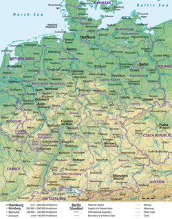 Map credit: Lencer and NordNordWestA general map, showing the geography of Germany, the seventh largest country in Europe and the second most populous. Located in Central Europe, Germany is second only to Russia in the number of borders it shares with other European countries (9).
 Map: Strebe, using GeocartThe Eckert II projection is an equal-area pseudocylindrical map projection presented by Max Eckert-Greifendorff in 1906. In the equatorial aspect (where the equator is shown as the horizontal axis) the network of longitude and latitude lines consists solely of straight lines, and the outer boundary has the distinctive shape of an elongated hexagon.
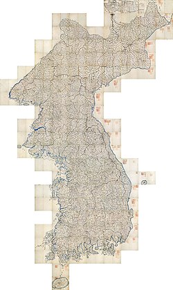 Daedongyeojido is a large scale map of Korea produced by Chosun Dynasty cartographer and geologist Kim Jeong-ho in 1861. Considered to mark the zenith of pre-modern Korean cartography, the map consists of 22 separate, foldable booklets, each covering approximately 47 kilometres (29 mi) (north-south) by 31.5 kilometres (19.6 mi) (east-west). Combined, they form a map of Korea that is 6.7 metres (22 ft) wide and 3.8 metres (12 ft) long. Daedongyeojido is praised for precise delineations of mountain ridges, waterways, and transportation routes, as well as its markings for settlements, administrative areas, and cultural sites.
 Photograph credit: European Space Agency / Sentinel-2The Yukon Delta is a river delta formed by the Yukon River as it drains into the Bering Sea. It is part of the larger Yukon–Kuskokwim Delta, which includes the delta of the Kuskokwim River. The Yukon River rises in British Columbia, Canada, and flows through Yukon before entering the U.S. state of Alaska. This August 2017 satellite image of the Yukon Delta shows how the river branches into numerous distributary channels that meander through the low-lying terrain on their way to the sea. The sandy colour of these channels and the coastal water is indicative of the marine sediment the river carries to the sea at this time of year.
 Photo: Jeff Schmaltz, MODIS Rapid Response Team, NASAA satellite photo of Great Britain and part of Ireland showing the extent of snow cover during the winter of 2009–2010, the coldest in Europe since 1981–82. Starting on 16 December 2009 a persistent weather pattern brought cold moist air from the north with systems undergoing cyclogenesis from North American storms moving across the Atlantic Ocean to the west, and saw many parts of Europe experiencing heavy snowfall and record low temperatures.
 Map: Strebe, using GeocartThe General Perspective projection is a map projection used in cartography in which the Earth is depicted as viewed from a finite distance above its surface. If the view precisely faces the center of the Earth, the projection is a vertical perspective projection; otherwise, it is a tilted perspective projection. Here is shown a vertical perspective from an altitude of 35,786 km over (0°, 90°W), corresponding to a view from geostationary orbit. Due to the horizon as seen from the viewpoint position, the projection always shows less than half of the Earth's surface: in this case neither of the North and South Poles is visible.
 Credit: Martin WaldseemüllerThe Waldseemüller map is a map drawn by German cartographer Martin Waldseemüller originally published in April 1507. It was one of the first maps to chart latitude and longitude precisely, the first map to use the name "America", and the first to depict the Americas as separate from Asia.
 Map: Grandiose, based on a map by the United States Geological SurveyA geological map of Yosemite National Park (full size), showing the Cathedral Peak Granodiorite, the largest unit in the Tuolumne Intrusive Suite, which in turn is the largest granitic suite in the park.
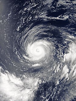 Typhoon Noru was the second-longest lasting tropical cyclone of the northwest Pacific Ocean on record. The fifth named storm of the 2017 Pacific typhoon season, it formed on July 19 and reached peak intensity on July 31 with 175 km/h (110 mph) 10-minute sustained winds. By this time, as shown in this satellite image, the typhoon was located south of Iwo Jima, and had taken on annular characteristics, with a symmetric ring of deep convection surrounding a 30 km (19 mi) well defined eye and fairly uniform cloud top temperatures. Traveling northwestward over an area of low ocean heat content, the eye became enlarged and ragged as the system weakened. By the time Noru made landfall over Wakayama Prefecture, Japan, on August 7, it had been downgraded to a severe tropical storm. It then dissipated over the Sea of Japan on August 9 as an extratropical cyclone.
 Map: Strebe, using the Geocart map projection softwareA two-point equidistant projection of Eurasia. All distances of other points from the two points marked in red (45°N 40°E and 30°N 110°E) are correct. This map is a derivative of NASA's Blue Marble summer month composite, with oceans lightened to enhance legibility and contrast.
 Map: Strebe, using the Geocart map projection softwareA map of the world using the Natural Earth projection, a pseudocylindrical projection which is neither conformal nor equal-area. The projection was designed by Tom Patterson, an American cartographer with the National Park Service who has developed several open-source tools and base maps for cartographers.


.svg)


.jpeg)


 Categories
 Commons
 Wikibooks
 Wikidata
 Wikinews
 Wikiquote
 Wikisource
 Wikiversity
 Wikivoyage
 Wiktionary

