Grid reference SX9067
near to Barton, Torbay, England
Coverage
We have
223 images
in grid square SX9067
Contribute
Explore gridsquare SX9067
Surrounding area
Maps
TIP: Click the map for more Large scale mapping
Tip: Click the map to open the coverage map
A sample of 12 photos from 223
for SX9067
- View this square in the Browser >>>
|
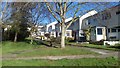
Off road houses
by John C
Houses between Golden park Avenue and Velland Avenue, Barton.
|

|
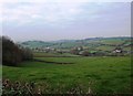
Countryside near Daccombe
by Derek Harper
A hillside at the head of the Aller Brook valley. Taken from Orestone Lane, which winds along the lower slopes to the poplars on the left. Daccombe Hill climbs diagonally to the right to housing at the fringe of Torquay at Barton Cross.
|
|
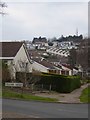
Housing estate in Barton
by David Smith
An estate of houses and bungalows on the northern edge of Torbay. Seen from the junction of Velland Avenue and Golden Park Avenue. In the background is the communications mast on Great Hill SX9168 : Great Hill, Torquay. - Communications mast
|

|
Field boundary near Daccombe
by Derek Harper
Looking right from SX9067 : Arable field near Daccombe.
|

|
Orestone Lane, near Daccombe
by David Smith
|
|
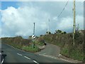
Great Hill Road leaving Barton Hill Road
by David Smith
|
|
View over the valley of the Aller Brook
Taken from outside the Parkdene Holiday Park
|
|
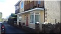
Former Barton Post Office
by John C
The house is the original Barton Post Office in Fore Street, Barton. Half the property was the shop, and the Post Master living in the other half.
Today the house bears the name, 'The Old Post Office'.
|

|
Daccombe farmland
View north towards Daccombe over a barbed-wire topped gate in Barton.
|

|
Field by Daccombe Brake
by Derek Harper
Seen from a gateway just ahead of SX9067 : Daccombe Brake, looking right. Perhaps the little wood on the right is called Daccombe Brake as well as the wood off to the left; they are less than 20 metres apart.
|

|
Play space, Lindisfarne Way
A green space in the lower and steeper part of a valley.
The housing being built around the sides and the edges.
The OS map defines this as a play space.
|
|
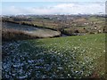
From Great Hill Road
by Derek Harper
Taken from the gate on the right of SX9067 : Junction of Great Hill Road and St Marychurch Road. This attractive view across Daccombe is passed by the hundreds of motorists who daily using the back road to Milber. A scattering of snow remains in the fields from falls earlier in the week.
|
Explore more images in this square: | View Filtering options | View all 223 images page by page >>> |
|