Grid reference SX5995
near to Okehampton, Devon, England
Coverage
We have
55 images
in grid square SX5995
Contribute
Explore gridsquare SX5995
Surrounding area
Maps
TIP: Click the map for more Large scale mapping
Tip: Click the map to open the coverage map
Sample images
Breakdown list
images taken from SX5995 [1]
A sample of 12 photos from 55
for SX5995
- View this square in the Browser >>>

|
Footbridge over the Okement
The Tarka Trail crosses the Okement as it heads North out of Okehampton
|

|
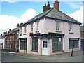
Okehampton : Exeter Road (set of 2 images)
by Lewis Clarke
Looking along Exeter Road.
|

|
Ashley Road
by DS Pugh
Ashley Road in Okehampton near the path to East Street.
|
|
Inspiration International Centre, Okehampton
Church of the nations.
|

|
Devon fuel prices - spring 2014
by Mr Ignavy
|
|
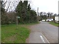
Footpath (Tarka Trail) on the north of Okehampton
by David Smith
This is where the trail leaves the paved road and follows a track to cross the River Okement
|
|
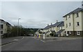
Houses in Link Road, Okehampton
by David Smith
|

|
Abbey Rise, Okehampton |

|
Okehampton Medical centre
This building is on the site of the former Cottage Hospital.
|
|
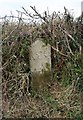
Old Boundary Marker by the B3215, Crediton Road, Okehampton Hamlets Parish
Parish Boundary Marker by the B3215, in parish of Okehampton Hamlets (West Devon District), Crediton Road, opposite No. 90, at side of lay-by, under hedge, North side of road.
Surveyed
Milestone Society National ID: DV_OKCR01bpb
|
|
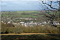
A view over Okehampton from East Hill
by John Lucas
|

|
Mill Road, Okehampton
by Derek Harper
Mill Road performs a loop around the southern side of the town; this is the eastern arm, set above the East Okement River.
|
Explore more images in this square: | View Filtering options | View all 55 images page by page >>> |
|