Grid reference SX4169
near to Albaston, Cornwall, England
Coverage
We have
23 images
in grid square SX4169
Contribute
Explore gridsquare SX4169
Surrounding area
Maps
TIP: Click the map for more Large scale mapping
Tip: Click the map to open the coverage map
Sample images
Breakdown list
A sample of 12 photos from 23
for SX4169
- View this square in the Browser >>>
|
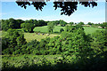
Wooded Valley near Norris Green
Fields and woods towards the top of the Danescombe valley. A short tributary of the Tamar flows down here for around 3kms before joining the river at Calstock.
|

|
Danescombe Farm
One of a handful of dwellings at the head of the Danescombe Valley.
|
|
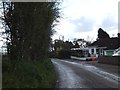
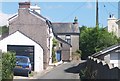
The edge of Norris Green
by David Smith
One side of the road is lined with bungalows, the other is farmland
|
|
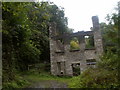
Danescombe Paper Mill
by John Lindsay
Active in the early 19th Century, this building is now only a shell.
|
|
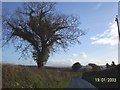
Holly tree near Trehill
by Linda Fowler
Growing on a typical Cornish hedge - looks soft but has a heart of stone!
|

|
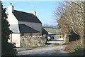
Norris Green
A picturesque hamlet not far form Gunnislake.
|
|
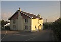
House at Norris Green
by Derek Harper
Looking to the right from the same spot as SX4169 : Junction at Norris Green, which shows that this lane goes to Metherell and Harrowbarrow.
|

|
Old Milestone by UC road, half a mile west of Calstock
by Ian Pethers
The Milestone is located possibly by an old tramline on the side of the road.� Parish of Calstock (Caradon District). Carved stone post, erected in the 19th Century.
Inscription reads:-
C / �
Milestone Society National ID: CW_LACL10A
|
|
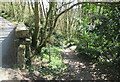
Path into Danescombe Woods
by Roy Hughes
|
|
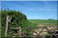
Footpath Gate near Newton Farm |
|
Norris Green
by Tony Atkin
No, not the one in Merseyside. This Cornish hamlet consists of a 19th century terrace of small houses, probably built for miners, and later development.
|
|
Newton Farm
Newton Farm, at Newton.
|
Explore more images in this square: | View Filtering options | View all 23 images page by page >>> |
|