

The Metro, also referred to as the Metro Mass Transit System[1] is a pre-War public transit system of Washington, D.C., administrated by the DC Transit Authority.
Background[edit]
An extensive transit network, providing service to Washington, D.C., and surrounding areas. The network of stations and rail lines were advertised as a faster, more convenient, cleaner commuter option.[2]
With portions of the system semi-automated, Protectrons were utilized for security, sales, and ticket collectors.[2] Wartime regulations also led to a heightened level of security among DCTA personnel, whose security teams were provided with Laser Pistols as standard sidearms as outlined in the DCTA Employee Handbook, overseen by the DCTA Regulatory Committee.[3] The authority signed contracts with local businesses to facilitate their operations, such as Darren's Discounts, an electronics wholesaler.[4]
DCTA metro stations are closed off with chain-link fences and warnings to keep out.[5] Metro Tickets can be found and will be recognized as valid by functioning Protectrons, while downloadable DCTA Metro Maps provide overviews of the metro network, some of which still have power. The sides of the City Liner buses mention the DC Metro Service Bureau.
Layout[edit]
| Map |
|---|
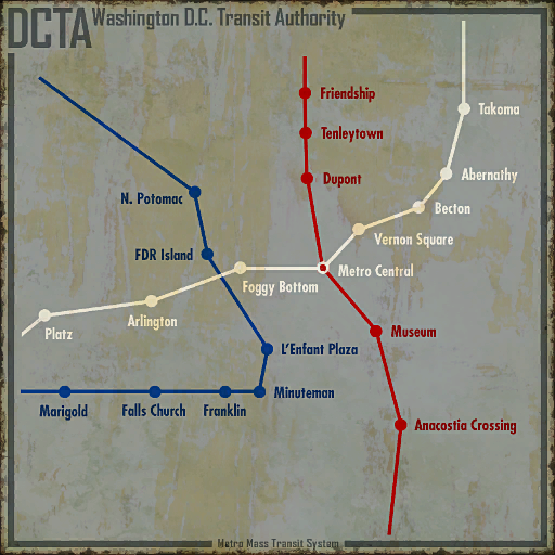  |
The metro system is comprised of rail stations, connected by three metro lines - Red Line, Blue Line, and White Line. The system is located underneath the streets of Washington, D.C., extending outwards to both the north and south. The metro network tunnels provide shelter to Raiders and Wastelanders alike, alongside dangers such as Super Mutants and Feral Ghouls.[6]
Stations are identified on the surface level by directional signs and obelisks with the metro symbol. The main stations have four escalators leading down to the station entrance. Smaller stations have single concrete staircases that lead down to the entrance underneath a curved roof. Double chain-link gates open to connect the entrance to the station's lobby.
Lines[edit]
The Red Line serves the central DC area and connects it with the northern and southern parts of the map. The line serves from Friendship in the north to Anacostia Crossing Station in the south, and interchanges with the White Line at Metro Central.
The Blue Line extends from Marigold in the southwest, to as far east as L'Enfant, and then northwest to North Potomac. The White Line extends from Takoma in the northeast through the center of the city (meeting the Red Line at Metro Central) through to Platz in the west.
Red[edit]
Blue[edit]
White[edit]
Mentioned[edit]
Connections[edit]
Signage[edit]
| Image | Name | Editor ID | Form ID |
|---|---|---|---|

|
Abernathy Station Sign | MetSignLBAber01 | 000C15B1 |

|
Anacostia Crossing Sign | MetSignLBAnaS01 | 000C1578 |

|
Becton Sign | MetSignMVBecton | 000C4081 |

|
Blue Line Sign | MetSignLBBluLine01 | 00092D57 |
| DC Metro Billboard | PosterMetro01 | 0007C60C | |

|
DC Transit Authority Sign | MetroEntranceDoor01 | 0001D584 |

|
Dupont Station Sign | SignDupontMetroPoster | 0003030A |

|
Eastbound Falls Church Sign | MetSignWallFalCE01T | 000C158E |

|
Eastbound Falls Sign | MetSignWallFalCBluT01L | 000C159D |

|
Eastbound Foggy Bottom Sign | MetSignWallFogBCryC01L | 000BDC36 |

|
Eastbound Freedom Street Sign | MetSignWallFreS01T | 000B07A0 |

|
Eastbound Vernon Square Station Sign | MetSignWallVerS01T | 000C9440 |

|
Eastbound Warrington Sign | MetSignWallBluTWarr01L | 000C9434 |

|
Exit to Museum of History Sign | MetSignExitTOHistMon01 | 00092D55 |

|
Exit to Museum of Technology Sign | MetSignExitTOTechMon01 | 00092D56 |

|
Foggy Bottom Sign | MetSignARFoggyBottom | 000C405D |

|
Franklin Sign | MetSignFCFranklin01 | 000C403F |

|
Franklin Station Sign | MetSignLBFrak01off | 000C15AC |

|
Jury St. Station Sign | MetSignLBJury01off | 000C15A6 |

|
Marigold Sign | MetSignFCMarigold | 000C4052 |

|
Marigold Station Sign | MetSignLBMari01off | 000C15AE |

|
Meresti Station Sign | MetSignLBMere01off | 000C15AB |

|
Metro Access Employee Sign | MetSignEmpOnly01 | 00092D54 |

|
Metro Central Sign | MetSignLBMetC01 | 00092D58 |

|
Metro Enjoy Your Visit Sign | MetSignThankYou01 | 00092D63 |

|
Metro Map | BusShelter02 BusShelter04 MetroMapNote01 |
00055C13 000542A4 000C0C7E |

|
Museum Station Sign | MetSignLBMusS01off | 000C15BA |

|
Northbound Dupont Station Sign | MetSignWallDupt01T | 00092D64 |

|
Northbound Friendship Station Sign | MetSignWallFrdS01T | 000C1593 |

|
Northbound to Dupont Station Sign | MetSignDuptPlat01 | 00092D53 |

|
Northbound to Metro Central Sign | MetSignMetCPlat01 | 000BDC19 |

|
Northbound to Red Line Trainyard Sign | MetSignRedTPlat01 | 000C9431 |

|
Pennsylvania Metro Central Sign | MetSignMVPaAndMetCent | 000C406A |

|
Platz Sign | MetSignARPlatz | 000C4089 |

|
Red Line Sign | MetSignLBRedLine01off | 000C157E |

|
Southbound Anacostia Crossing Sign | MetSignWallAnaC01T | 000BDC17 |

|
Southbound to Anacostia Crossing Sign | MetSignAnaCPlat01 | 000BDC1B |

|
Southbound to Museum Station Sign | MetSignMusSPlat01 | 00092D60 |

|
Southbound to Tenleytown Station Sign | MetSignTenSPlat01 | 000C1588 |

|
Takoma Station Sign | MetSignLBTakS01off | 000C15A8 |

|
Tenleytown Station Sign | MetSignLBTenS01off | 000C15AD |

|
Westbound Abernathy Station Sign | MetSignWallAber01T | 000C158C |

|
Westbound Blue Line Trainyard Sign | MetSignWallBluT01T | 000C158B |

|
Westbound Crystal City Sign | MetSignWallCryC01T | 000BDC49 |

|
Westbound Foggy Bottom Sign | MetSignWallFogB01T | 000B079E |

|
Westbound Marigold Sign | MetSignWallFalCMari01R | 000C9438 |

|
Westbound to Falls Church Sign | MetSignFalCWPlat01 | 000C1589 |

|
White Line Station | MetSignLBWhtLine01 | 00092D5E |
Notes[edit]
- The Pip-Boy world map may show a different name for stations than are shown on local maps and when fast traveling, the map marker and where one arrives may not be one and the same, as seen with both Georgetown West and Dupont stations.
- The "D.C.'s fastest highway" advertisement lists two stations, Smithsonian, and Eastern Market, that are not found in-game.
- Union Station is mentioned in Fallout 76.[7]
Appearances[edit]
The Metro Mass Transit System appears in Fallout 3.
Behind the Scenes[edit]
- Many stations are named after their real-world equivalents, including Anacostia, Dupont Circle, Falls Church, Foggy Bottom, Friendship Heights, L'Enfant, Metro Central, Mount Vernon Square, Takoma, and Tenleytown.[Ext 1]
- According to Joel Burgess, the developers "envisioned a pre-war system of stations and tracks which mimics D.C.'s real-world public transit system, and used that to guide our development of the DCTA metro."[Dev 1]
- The "Prepare for the Future" promotional video mentions that on Sundays, all passengers were allowed to ride for free.[8]
Gallery[edit]


Blue Line metro sign

Loading screen

Prepare for the Future video

Signage
Advertisement


- Concepts

Concept art by Adam Adamowicz


References[edit]
- ↑ DCTA Metro Map
- ↑ 2.0 2.1 Text on DCTA advertisement
- ↑ DCTA Laser Firearms Protocol
- ↑ Robot repair center terminal entries; Sector A emergency terminal, Note from Management regarding Sector B
- ↑ Keep Out signs
- ↑ Fallout 3 loading screen: "The only way to reach the Super Mutant-occupied D.C. ruins is by traveling underground, usually through the abandoned Metro tunnels."
- ↑ Paige's journal, entry 1
- ↑ Fallout 3 promotional content; Prepare for the Future, Channel 4: Tickets Please