Avoid common mistakes on your manuscript.
Introduction
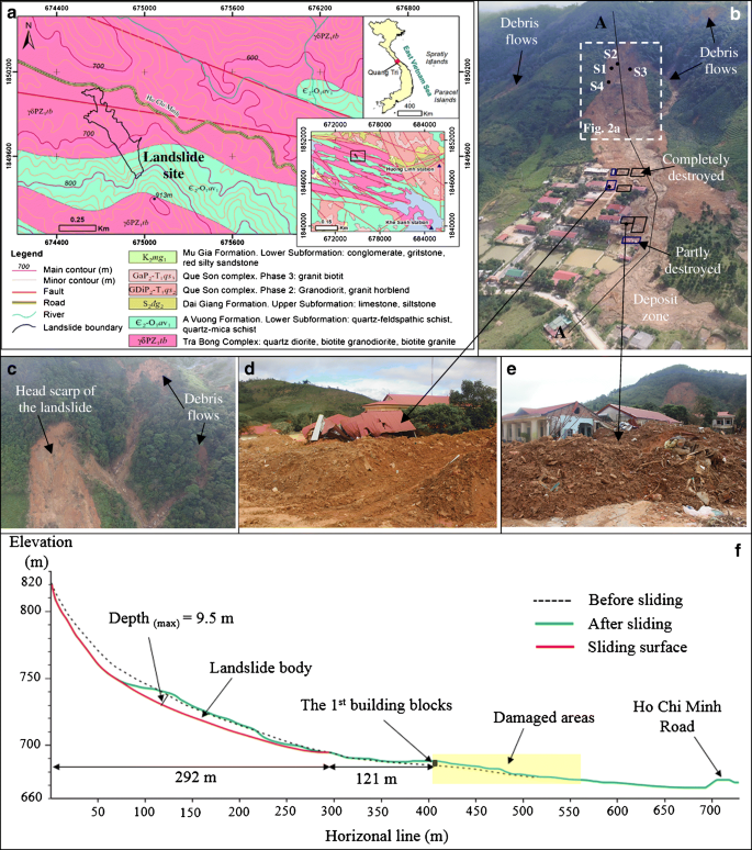
The 2020 monsoon season in Vietnam was unusual because of the numerous tropical cyclones. In particular, the northern and central regions of the country were hit by six tropical cyclones in a short period, from October 6 to October 28. Heavy rains brought by these cyclones are considered to have been responsible for triggering many landslides and disastrous floods in the provinces of Quang Tri, Thua Thien Hue, and Quang Nam, causing deaths and serious economic damage. The landslide that occurred on October 18, 2020, in Cop hamlet, Huong Phung commune, Huong Hoa district, Quang Tri Province was a catastrophic event that claimed the lives of 22 soldiers in barracks. The landslide debris moved down the hilltop, completely burying four buildings in its path and partly damaging three buildings along its path (Fig. 1). According to a survivor, the landslide was preceded by a loud explosive noise, and the landslide mass struck the buildings about 10 s later. The buildings accommodated 29 people at the time of the catastrophe. This landslide was probably one of the single worst events in the recorded history of Vietnam in terms of the death toll. The Huong Phung landslide gained prominent public attention not only because of the death toll but also due to its uniqueness in terms of size, causative factors, and sliding mechanism. This article reports the overall features and preparatory and triggering factors of the Huong Phung landslide.
a Geological map of the study area and landslide location (based on Geological map at the scale of 1:50.000 created by Dien et al. 1994). b, c UAV photo of the landslide and debris flows. d, e Damages caused by the landslide. f Profile of the landslide along A–A
Regional setting
The study area is located in a mountainous region with elevation ranging from approximately 500 to 913 m above mean sea level with an average slope angle varying from 15 to 30°. The slope is covered by a secondary forest with mainly low-value trees, shrubs, and vegetation on the top, while the lower part of the mountain is used for crop cultivation or left abandoned. This area is strongly affected by the A Luoi–Dakrong deep-seated fault, a 2–5-km-wide cataclastic fault zone that runs from the northwest to the southwest. The geological settings are characterized by the Tra Bong Complex, which consists of granitoid rocks (quartz diorite, biotite granodiorite, and biotite granite), and the A Vuong Formation, which includes quartz–feldspathic schist and quartz–mica schist (Fig. 1a, Dien et al. 1994). As indicated in Fig. 1a, the head scarp and upper part of the landslide body were situated in the A Vuong Formation, while the lower part was formed on the Tra Bong Complex. In addition to geology, the study area was severely influenced by the tropical monsoon, which has an annual average of about 6–7 tropical storms (IMHEN and UNDP 2015). High-intensity rainfall during the monsoon seasons is commonly recognized as the main landslide triggering factor in the Central Region of Vietnam (Thien and Ly 2013; Tan and Tao 2014).
Preliminary results from the site survey and data analysis
Landslide features
The October 18, 2020 landslide took place on the concave slope (Fig. 1b and 1c). The upper part of this terrain is very steep with a slope angle of about 50°, whereas the lower part is gentler with a slope angle of 12°. On the hillside, the slope angle ranges from 20 to 30°. The landslide occurred as debris slide moved from the steep upper slope, turning into a rapid and large flow-like motion of mixed soil and fragmented rocks and sweeping over the army barracks 121 m away from the toe of the rupture surface. The mass movement was rotational with an exposed rupture surface on the head scarp, which was roughly curved upward. The crown of the landslide sits at an elevation of 820 m above mean sea level, and the toe of the rupture surface is at an elevation of 694 m above mean sea level. The length (Lr), width (Wr), and depth (Dr) of the rupture surface were 293, 123, and 9.5 m, respectively (Fig. 1c). The landslide traveled over more than 700 m and mobilized at the apparent angle of 12.4°. The mass movement further entrained unstable deposits along the stream channel and the run-out path. The landslide volume (V), estimated by the equation V = π·Lr·Wr·Dr/6 (WP/WLI 1990; Cruden and Varnes 1996), was approximately 180,000 m3. The debris material due to the entrainment process involved an area of more than 2.0 ha, and the volume was estimated to be about 15,000-20,000 m3. Figure 1b also shows the rainfall-triggered debris flows that occurred after the catastrophic slide. The site evidence indicates that these debris flows initiated from the top of the mountain on the southwest side of the landslide source and traveled downward along the stream channel. The flows then eroded a part of the original landslide body and slid over the landslide accumulation zone.
Geological characteristics
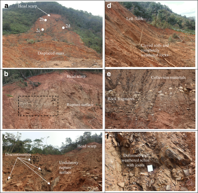
The geological features of the landslide are very complex because of its location on the boundary of the Tra Bong Complex and the A Vuong Formation (Fig. 1a). Site evidence indicates that the slope strata are characterized by highly to completely weathered rocks, which are classified as grades IV to VI (ISRM 2007). The landslide occurred within the deeply weathered rock layers up to about 20–25 m on the top of the mountain (Fig. 2). The sliding area is formed by weathered schist and granitoid rocks and unconsolidated colluvium. The landslide deposits are mainly composed of clayey and silty soils mixed with rock fragments (Fig. 2a–d). Rock masses that belong to the crush and cataclastic fault zones were strongly deformed, fractured, and sheared due to regional tectonic movements along the fault lines. Discontinuities and joints are visible in the rock masses and along the rupture surface (Fig. 2e–f). These features reduce the strength of the soil layers and provide favorable conditions for the build-up of the groundwater table in deep layers of the slope, which contributed to the severity of the sliding. The geological characteristics of the slope are, therefore, one of the preparatory factors causing the sliding.
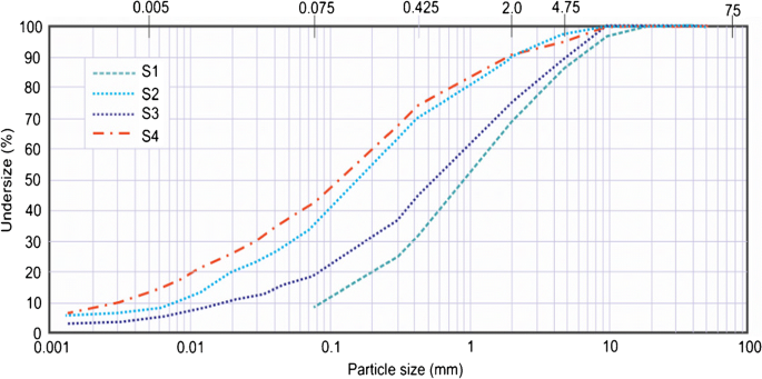
In the site survey, four samples were collected along the sliding surface, namely samples S1, S2, S3, and S4, for further investigation of geotechnical characteristics of soils within the sliding surface (Fig. 1b). The grain size distribution is shown in Fig. 3, and sample properties are presented in Table 1. The sliding materials vary from well-graded sand (sample S1) to silty sand (samples S2, S3, and S4). Sample S1 has grains with the mean diameter D50 = 1.03 mm and uniformity coefficient Cu = 16.42. Sample S4 is the finest, with a mean diameter of D50 = 0.14 mm and uniformity coefficient Cu = 65.6.
Rainfall analysis
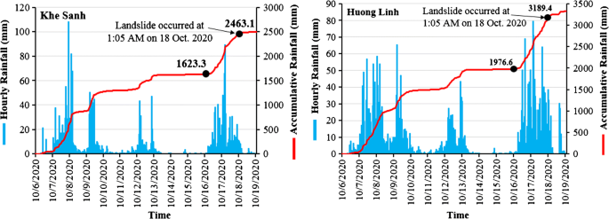
Precipitation data recorded at Khe Sanh station, about 14 km, and Huong Linh station, about 11 km from the landslide site (Fig. 1a), are shown in Fig. 4 (VDMA 2020). Rain fell from October 6 to 18 due to four tropical cyclones, including a tropical depression from October 6 to 8, Typhoon Linfa (October 9–12), Typhoon Nanka (October 11–14), and tropical depression Ofel (October 14–18). The October 18 landslide occurred with a very high amount of accumulated precipitation (2463.1 mm) and, after about 12 days, from midnight on October 6 to 1:00 a.m. on October 18. The intensity of rainfall was very high on October 16 and 17, while less rain fell on October 14 and 15. The 48-h accumulative rainfall measurements prior to the landslide event were 839.8 and 1212.8 mm at Khe Sanh and Huong Linh stations. Therefore, the rainfall which triggered the Huong Phung landslide was characterized by high intensity over a short time. The rainfall data analysis indicates that high accumulated rainfall over a long duration was the main trigger of the Huong Phung landslide.
Hourly rainfall and the accumulative precipitation at the landslide event (VDMA 2020) at Khe Sanh station from midnight on October 6 to midnight on October 19 (left) and at Huong Linh station from midnight on October 10 to midnight on October 19 (right)
Concluding remarks
The October 18, 2020 landslide located in Huong Phung, Huong Hoa, Quang Tri, Vietnam was the largest landslide induced by rainfall during the 2020 typhoon season. It caused the highest number of injuries and is one of the worst single sliding events recorded in Vietnam. This paper briefly addresses the associated causes, mechanism, and effects of the landslide. This study shows that the Huong Phung landslide was a rotational landslide that traveled rapidly over a long distance. The geologic and topographic features were preparatory factors that contributed to the failure, while the high accumulation of rainfall during the preceding 12 days was the main triggering factor. The study area has a complex geology and history of tectonic activities. Therefore, it is necessary to further investigate the sliding mechanism, the characteristics of the slope strata, and the engineering geological properties, and create a numerical model of the landslide. As a significant lesson learned from the Huong Phung disaster, it is imperative to establish land-use planning and landslide susceptibility mapping at a large scale, and a landslide early warning system in the landslide-prone areas of Vietnam where the risk of a catastrophic event is very high due to high population density and vulnerable structures.
References
Dien VM, Hoa BC, Hung DC, Lai LN, Minh NB, Truong NT (1994) Geological map of Quang Tri and Thua Thien Hue areas (E-48-143B, Scale 1:50,000). Vietnam, Department of Geology and Minerals of
IMHEN and UNDP (2015) The Vietnam special report on managing the risks of extreme events on disasters to advance climate change adaptation. Vietnam Publishing House of Natural Resources, Environment and Cartography, 456 pages.
ISRM (2007) The complete ISRM suggested methods for rock characterization, testing and monitoring: 1974–2006. Ulusay, R., Hudson, J. (Eds.). Commission on testing methods, International Society for Rock Mechanics, 628 pp.
Tan MT, Tao NV (2014) Studying landslides in Thua Thien Hue province. Vietnam J Earth Sci 36(2):121–130
Thien DQ, Ly ND (2013) Commentary of landslide disaster along Ho Chi Minh road from Quang Binh to Thua Thien. Vietnam J Earth Sci 35(3):230–240
VDMA (2020) Reports on landslides and flood disasters and rainfall data in October, 2020. Vietnam Disaster Management Authorities.
Acknowledgements
This research is funded by Vietnam National Foundation for Science and Technology Development (NAFOSTED) under grant number 105.08-2019.14. The authors would also like to express our thanks to Assoc. Prof. Do Dinh Toat (Institute of Geotechnology and Environment), Assoc. Prof. Vu Cao Minh (Institute of Geological Sciences, Vietnam Academy of Science and Technology and Msc. Huynh Thanh Binh (Institute of Transport Science and Technology) for their valuable discussion and support during this study.
Funding
This research is funded by Vietnam National Foundation for Science and Technology Development (NAFOSTED) under grant number 105.08-2019.14.
Author information
Authors and Affiliations
Corresponding author
Rights and permissions
About this article
Cite this article
Van Tien, P., Luong, L.H., Duc, D.M. et al. Rainfall-induced catastrophic landslide in Quang Tri Province: the deadliest single landslide event in Vietnam in 2020. Landslides 18, 2323–2327 (2021). https://doi.org/10.1007/s10346-021-01664-y
Published:
Issue date:
DOI: https://doi.org/10.1007/s10346-021-01664-y

