The landscape of urban development is undergoing a profound transformation, driven by the powerful convergence of spatial computing, artificial intelligence (AI), and digital twin technology. These three technological pillars, once distinct, are now intertwining to create intelligent, immersive, and predictive environments that are revolutionizing how we plan, manage, and interact with our cities. This synergy is not merely an incremental improvement; it represents a fundamental shift in urban planning, enabling unprecedented opportunities to solve complex real-world problems and foster sustainable, efficient, and resilient urban spaces.
Understanding the Core Technologies
To grasp the full impact of this convergence, it's essential to understand each component's role:
Spatial Computing: At its heart, spatial computing involves interacting with technology in a way that integrates or manipulates elements in the physical world. For urban planning, this means creating a digital overlay of the physical city, allowing planners and citizens to visualize and interact with urban data in a highly intuitive, three-dimensional manner. It's about blending digital content with the physical environment, creating immersive experiences that enhance understanding and decision-making. As NTT DATA highlights, it's about "seamlessly integrating digital objects into physical environments," a concept that is becoming increasingly pivotal in 2024 with a projected market growth of 18.30% annually, soaring from $124 billion in 2023 to an impressive $620 billion by 2032. NTT DATA Group - Navigating the Spatial Computing Revolution. You can delve deeper into the concept of spatial computing and its evolution at exploring-spatial-computing.pages.dev.
Digital Twin: A digital twin is a virtual replica of a physical entity, process, or system, constantly updated with real-time data from its physical counterpart. In urban planning, a city's digital twin is a living, breathing model that mirrors the actual city's infrastructure, population movements, environmental conditions, and more. This virtual model provides a comprehensive, up-to-the-minute view of the urban environment, allowing for continuous monitoring and analysis.
AI's Role: Artificial intelligence acts as the intelligent brain of this integrated system. AI algorithms process the vast amounts of real-time data streamed from the digital twin, extracting insights, identifying patterns, and making predictions. Within the spatial environment, AI enables intelligent interactions, automates analyses, and provides actionable recommendations, transforming raw data into predictive insights for urban planners. As Deloitte notes, multimodal AI can process diverse data types—text, image, audio, spatial, or structured—allowing it to serve as a bridge between different data sources and interpret context between spatial and business data. Deloitte - Spatial computing takes center stage.
Revolutionizing Urban Planning: Use Cases & Examples
The combined power of spatial computing, AI, and digital twins is unlocking unprecedented capabilities in urban planning:
1. Real-time City Models and Traffic Management: Imagine a holographic 3D model of a city, overlaid with real-time traffic data, public transport movements, and pedestrian flows. Spatial computing allows urban planners to "walk through" this virtual city, observing congestion points, analyzing the impact of events, and simulating changes to traffic light timings or road closures. AI, fed by the digital twin's continuous data stream, can predict traffic bottlenecks before they occur, suggesting optimal routing for emergency services or dynamic adjustments to traffic signals to alleviate congestion.
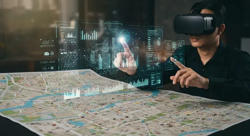
Alt-text: An urban planner wearing an augmented reality headset, interacting with a holographic 3D model of a city that shows real-time traffic flow and infrastructure data. The model is overlaid on a physical city map, with data points highlighted by AI-driven insights.
2. Infrastructure Development and Predictive Maintenance: Digital twins of city infrastructure – bridges, water pipes, power grids – can be continuously monitored using sensors. Spatial computing provides a visual interface for inspecting these virtual assets, allowing engineers to identify potential issues from a control room or on-site with augmented reality overlays. AI analyzes sensor data to predict equipment failures, identify areas of stress in aging infrastructure, and recommend optimal maintenance schedules, minimizing disruptions and maximizing the lifespan of critical urban systems. For instance, an energy company uses drones for 3D scans of equipment and applies computer vision to ensure assets operate within predefined tolerances, creating high-fidelity digital twins from engineering, operational, and ERP systems. This approach, though in the energy sector, directly translates to urban infrastructure management. Deloitte - Spatial computing takes center stage.
3. Emergency Response and Disaster Preparedness: In the event of a natural disaster or major incident, a city's digital twin, powered by real-time data and AI, can become an invaluable tool. Emergency responders can use spatial computing interfaces to visualize the affected areas, track the movement of personnel and resources, and simulate different response scenarios. AI can predict the spread of fires, identify optimal evacuation routes, or assess the impact of flooding, enabling faster, more coordinated, and more effective emergency operations. Fraser Health Authority in Canada, for example, has pioneered leveraging simulation models to improve care by creating a system-wide digital twin for powerful visualizations of patient movement and to determine the impact of deploying different care models. This concept can be extended to city-wide emergency response.
The Technical Nexus: Data Flow and Intelligence
The seamless integration of these technologies relies on a continuous flow of data and intelligent processing:
- Sensors: The physical city is equipped with a myriad of sensors – traffic cameras, environmental sensors, IoT devices on infrastructure, smart meters, and more. These sensors continuously collect real-time data about every aspect of urban life.
- Digital Twin: This raw sensor data is fed into the city's digital twin, updating its virtual representation in real-time. This creates a dynamic, constantly evolving model that accurately reflects the current state of the physical city.
- AI Processing: AI algorithms then process this massive influx of data from the digital twin. This involves machine learning for pattern recognition, predictive analytics for forecasting future conditions, and deep learning for complex scenario analysis.
- Spatial Computing Visualization/Interaction: The insights generated by AI are then rendered and visualized within a spatial computing environment. This could be an augmented reality (AR) overlay on a physical map, a virtual reality (VR) simulation of a proposed development, or an interactive 3D model accessible via various devices. Users can then interact with this intelligent, spatial representation of the city, gaining deeper insights and making informed decisions.
Here's a conceptual data structure for a digital twin asset in an urban context and a simplified AI processing example:
# Conceptual Digital Twin for a Smart City Infrastructure Asset
city_asset_data = {
    "asset_id": "bridge_A7",
    "type": "bridge",
    "location": {"latitude": 34.0522, "longitude": -118.2437, "elevation": 10.0}, # Spatial coordinates
    "sensor_readings": {
        "structural_stress_mpa": 120.5,
        "vibration_hz": 8.2,
        "temperature_c": 25.1,
        "traffic_load_vehicles_per_min": 55
    },
    "status": "normal_operation",
    "last_inspection": "2024-04-15",
    "maintenance_due": "2025-04-15"
}

# Conceptual AI processing for predictive maintenance in a spatial urban context
# (This would run on data streamed from the digital twin)
def analyze_infrastructure_data(data):
    if data["structural_stress_mpa"] > 110 and data["vibration_hz"] > 7.5:
        # AI determines a potential anomaly or early sign of wear
        print("Anomaly detected in bridge_A7. Elevated structural stress and vibration.")
        # In a spatial computing application, this could trigger:
        # 1. A visual alert (e.g., a flashing red outline) on the digital twin of the bridge.
        # 2. An augmented reality overlay for on-site inspection, highlighting problem areas.
        # 3. A recommendation for a detailed structural assessment.
        return {"alert": True, "recommendation": "Urgent structural assessment needed for bridge_A7."}
    if data["traffic_load_vehicles_per_min"] > 60:
        print("High traffic load detected on bridge_A7. Monitor for congestion.")
        # This could trigger a traffic flow adjustment recommendation in the spatial system.
        return {"alert": False, "traffic_alert": True}
    return {"alert": False, "traffic_alert": False}

# Example of calling the analysis (in a real system, this would be continuous)
# analysis_result = analyze_infrastructure_data(city_asset_data["sensor_readings"])
# if analysis_result["alert"]:
#     display_spatial_alert(city_asset_data["location"], analysis_result["recommendation"])
# elif analysis_result["traffic_alert"]:
#     suggest_traffic_management_spatial_action(city_asset_data["location"])

Alt-text: A conceptual image showing data flowing from physical city sensors (represented by small glowing dots on buildings and roads) into a central holographic digital twin of the city. AI algorithms are depicted as glowing neural networks processing this data, and the output is a dynamic, interactive spatial computing visualization that urban planners are interacting with using hand gestures.
Challenges and the Future Landscape
While the potential is immense, several challenges need to be addressed. Data privacy and security are paramount, especially when dealing with sensitive urban data. Interoperability between various systems and data formats remains a hurdle, requiring standardized approaches for seamless data exchange. Furthermore, the sheer volume of data necessitates robust infrastructure and high-performance computing. As Deloitte points out, "data isn’t always interoperable between systems," and "building the data pipelines to get the correct spatial data into visual systems is a thorny engineering challenge."
Despite these challenges, the future of urban planning is undeniably shaped by this convergence. As spatial computing hardware becomes more sophisticated and accessible (like the Apple Vision Pro, as mentioned by XR Today XR Today - 6 Spatial Computing Trends to Watch in 2024), AI becomes more intelligent and autonomous, and digital twins become more comprehensive, our cities will transform into truly smart, responsive, and sustainable ecosystems. This integrated approach promises to create urban environments that are not only more efficient and resilient but also more livable and responsive to the needs of their inhabitants, charting a course towards a more connected and dynamic future.

Top comments (0)