
Sariaya
An Sariaya sarong primera klaseng banwaan sa provincia kan Quezon, Filipinas. An designadong zip code kaini iyo 4322.
Sariaya | |||
|---|---|---|---|
Municipality of the Philippines | |||
 | |||
| |||
 Kinamumugtakan kan Sariaya | |||
 | |||
| Tagboan: 13°58′12″N 121°31′48″E Tagboan: 13°58′12″N 121°31′48″E | |||
| Nasyon | Filipinas | ||
| Barangay | 43 | ||
| Pamamahala | |||
| • Electorado | 105,746 votantes (23 Enero 2025) | ||
| Hiwas | |||
| • kabilugan | 212.16 km2 (81.92 sq mi) | ||
| Elebasyon | 139 m (456 ft) | ||
| Populasyon | |||
| • kabilugan | 172,018 | ||
| • Densidad | 810/km2 (2,100/sq mi) | ||
| • Saro | 39,329 | ||
| Economia | |||
| • Klase | primero klaseng banwaan | ||
| • Ingresos | ₱ 646,311,230.98 Piso kan Filipinas (2024) (2024) | ||
| • Activos | ₱ 1,639,432,271.45 Piso kan Filipinas (2024) (2024) | ||
| • Pasivos | ₱ 637,194,431.84 Piso kan Filipinas (2024) (2024) | ||
| • Gastos | ₱ 333,500,114.78 Piso kan Filipinas (2024) (2024) | ||
| Kodigo nin postal | 4322 | ||
| PSGC | 0405645000 | ||
| Kodigo telefonico | 42 | ||
| Klima | tropical rainforest climate | ||
| Tataramon | tataramon na Tagalog | ||
| Websityo | www | ||


Susog sa sensus kan 1 Hulyo 2024, igwa ining 172,018 katawong nag-eerok digdi sa 39,329 kaharongan. Igwa ining sukol na 212.16 kilometro kwadrado.
Mga barangay
baguhonNababanga an Sariaya sa 43 barangay.
|
|
|
Demograpiko
baguhon| Taon | Tawo | ±% p.a. |
|---|---|---|
| 1903 | 12,453 | — |
| 1918 | 14,158 | +0.86% |
| 1939 | 25,736 | +2.89% |
| 1948 | 29,904 | +1.68% |
| 1960 | 42,089 | +2.89% |
| 1970 | 58,997 | +3.43% |
| 1975 | 66,847 | +2.54% |
| 1980 | 74,148 | +2.09% |
| 1990 | 91,081 | +2.08% |
| 1995 | 100,709 | +1.90% |
| 2000 | 114,568 | +2.80% |
| 2007 | 128,248 | +1.57% |
| 2010 | 138,894 | +2.94% |
| 2015 | 148,980 | +1.34% |
| 2020 | 161,868 | +1.76% |
| 2024 | 172,018 | +1.47% |
| Toltolan: Philippine Statistics Authority[3][4][5][6] | ||
Kataytayan nin mga ladawan
baguhon An Simbahan katoliko ni San Francisco de Assisi
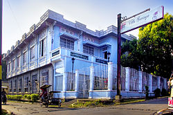 Don Catalino Rodriguez Ancestral House, bistado man bilang Villa Sariaya
 Harong ni Gob. Natalio Enriquez


Toltolan
baguhon- ↑ "2024 Census of Population (POPCEN) Population Counts Declared Official by the President". Philippine Statistics Authority. Hulyo 17, 2025. Retrieved Hulyo 18, 2025. Check date values in:
|access-date=, |date=(help) - ↑ Error: Unable to display the reference properly. See the documentation for details.
- ↑ Sensus kan Populasyon (2015). "Rehiyon IV-A (Calabarzon)". Kabuuhang Populasyon kan lambang Provincia, Syudad, Banwaan asin Barangay. PSA. Retrieved 20 Jun 2016.
- ↑ Census of Population and Housing (2010). "Rehiyon IV-A (Calabarzon)". Kabuuhan populasyon sa lambang Provincia, Syudad, Banwaan asin Barangay. NSO. Retrieved 29 Jun 2016.
- ↑ Mga Sensus kan Populasyon (1903–2007). "Rehiyon IV-A (Calabarzon)". Table 1. Population Enumerated in Various Censuses by Province/Highly Urbanized City: 1903 to 2007. NSO.
- ↑ "Province of". Municipality Population Data. LWUA Research Division. Retrieved 17 December 2016.
Mga panluwas na takod
baguhon- PhilAtlas.com
- Philippine Standard Geographic Code
- Local Governance Performance Management System
- Sariaya, Quezon, Online @Sariaya.net Archived 2016-03-06 at the Wayback Machine.
- Sariaya, Quezon, Web Portal Archived 2008-06-02 at the Wayback Machine.
- Sariaya Institute Alumni Archived 2008-07-19 at the Wayback Machine.