| Locality | Latitude | Longitude | Distance | Bearing |
|---|
| Crawford Dam, Crawford, Dawes County, Nebraska, USA | 42° 39' 56" N | 103° 25' 15" W | 2.0km (1.3 miles) | |
| Crow Butte uranium deposit, Dawes County, Nebraska, USA | 42° 38' 45" N | 103° 21' 9" W | 6.4km (4.0 miles) | |
| Whitney, Dawes County, Nebraska, USA | 42° 47' 6" N | 103° 15' 22" W | 17.1km (10.6 miles) | |
| Sioux County meteorite, Sioux County, Nebraska, USA | 42° 34' 59" N | 103° 40' 0" W | 23.5km (14.6 miles) | |
| Orella, Sioux County, Nebraska, USA | 42° 53' 38" N | 103° 34' 42" W | 27.1km (16.8 miles) | |
| Marsland meteorite, Dawes County, Nebraska, USA | 42° 27' 0" N | 103° 17' 59" W | 27.5km (17.1 miles) | |
| Harrison, Sioux County, Nebraska, USA | 42° 41' 14" N | 103° 52' 58" W | 38.4km (23.9 miles) | |
| Agate Springs Fossil Quarries, Agate Fossil Beds National Monument, Sioux County, Nebraska, USA | 42° 25' 0" N | 103° 43' 39" W | 39.3km (24.4 miles) | |
| Ardmore, Fall River County, South Dakota, USA | 43° 1' 9" N | 103° 39' 22" W | 42.4km (26.3 miles) | |
| Refinite Corp Bentonite Pit, Ardmore, Fall River County, South Dakota, USA | 43° 1' 19" N | 103° 39' 29" W | 42.7km (26.5 miles) | |
| Agate, Sioux County, Nebraska, USA | 42° 25' 11" N | 103° 47' 37" W | 42.8km (26.6 miles) | |
| Oelrichs, Fall River County, South Dakota, USA | 43° 10' 44" N | 103° 13' 49" W | 57.1km (35.5 miles) | |
| Amy No. 1, Edgemont Uranium Mining District, Fall River County, South Dakota, USA | 43° 11' 40" N | 103° 44' 11" W | 62.7km (39.0 miles) | |
| Johnson-Starlite, Edgemont Uranium Mining District, Fall River County, South Dakota, USA | 43° 12' 12" N | 103° 43' 46" W | 63.4km (39.4 miles) | |
| Provo, Fall River County, South Dakota, USA | 43° 11' 28" N | 103° 49' 28" W | 65.7km (40.8 miles) | |
| Unknown Uranium Occurrence (MRDS - 10018885), Hartville Mining District, Goshen County, Wyoming, USA | 42° 18' 46" N | 104° 3' 34" W | 67.1km (41.7 miles) | |
| Spoon Buttes, Goshen County, Wyoming, USA | 42° 19' 30" N | 104° 4' 47" W | 67.7km (42.0 miles) | |
| Baxter, Edgemont Uranium Mining District, Fall River County, South Dakota, USA | 43° 15' 59" N | 103° 43' 59" W | 69.9km (43.5 miles) | |
| Lo Ra No. 1, Edgemont Uranium Mining District, Fall River County, South Dakota, USA | 43° 16' 32" N | 103° 43' 49" W | 70.8km (44.0 miles) | |
| Wildcat and Cedar Canyons, Fall River County, South Dakota, USA | 43° 18' 51" N | 103° 35' 39" W | 71.7km (44.6 miles) | |
| Section 36-8S-3E (State 1 S.D. Min. Lease; Jarosa State Lease), Edgemont Uranium Mining District, Fall River County, South Dakota, USA | 43° 17' 36" N | 103° 42' 25" W | 72.0km (44.7 miles) | |
| Phillip and Flanagan Claims, Sweetwater County, Wyoming, USA | 42° 27' 0" N | 104° 13' 59" W | 72.0km (44.8 miles) | |
| Washboard, Edgemont Uranium Mining District, Fall River County, South Dakota, USA | 43° 18' 8" N | 103° 41' 34" W | 72.5km (45.1 miles) | |
| N Gulch, Edgemont Uranium Mining District, Fall River County, South Dakota, USA | 43° 19' 31" N | 103° 35' 20" W | 72.9km (45.3 miles) | |
| Damsite, Edgemont Uranium Mining District, Fall River County, South Dakota, USA | 43° 18' 30" N | 103° 41' 46" W | 73.3km (45.5 miles) | |
| Accidental No. 1 Mine, Edgemont Uranium Mining District, Fall River County, South Dakota, USA | 43° 18' 56" N | 103° 41' 14" W | 73.8km (45.9 miles) | |
| Accidental No. 10 Mine, Edgemont Uranium Mining District, Fall River County, South Dakota, USA | 43° 18' 54" N | 103° 41' 23" W | 73.8km (45.9 miles) | |
| Accidental No. 3 occurrence, Edgemont Uranium Mining District, Fall River County, South Dakota, USA | 43° 19' 3" N | 103° 41' 23" W | 74.1km (46.0 miles) | |
| Unknown Uranium Occurrence (MRDS - 10181767), Niobrara County, Wyoming, USA | 42° 59' 44" N | 104° 14' 25" W | 75.9km (47.2 miles) | |
| Unknown Uranium Occurrence (MRDS - 10279304), Niobrara County, Wyoming, USA | 42° 59' 44" N | 104° 14' 25" W | 75.9km (47.2 miles) | |
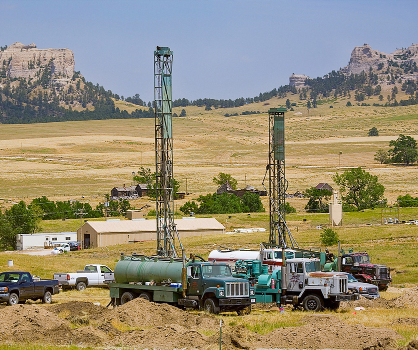


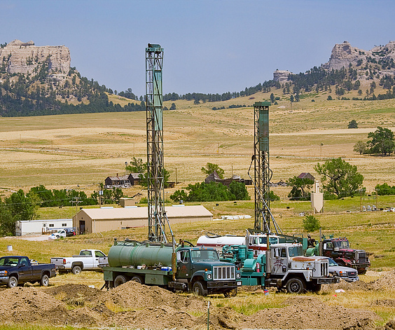
Crow Butte uranium deposit, Dawes County, Nebraska, USA